Geotimes

Feature
Water, Agriculture
and Land Cover: Lessons for the Postwar Era
Mohamed Sultan, Richard Becker, Ahmad Al-Dousari, Abdul Nabi
Al-Ghadban and Elizabeth Bufano
Countries of the Middle East have many reasons to envy their neighbor Iraq:
not only does Iraq have the second-largest proven oil reserves (after Saudi
Arabia), but it has more renewable water resources than any other Middle Eastern
nation. Thousands of years ago, the plentiful water resources of the Tigris
and Euphrates rivers promoted widespread and organized cultivation along their
riverbanks, which led to the development of the world’s earliest civilization
in the river valleys — the Mesopotamian civilization. Since then, agriculture
has been the primary economic activity of the Iraqis. But the past century has
brought considerable change.
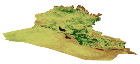 A
3-D representation for the Normalized Difference Vegetation Index (NDVI) draped
over vertically-exaggerated topographic data (1-kilometer digital terrain elevation
data) for Iraq. The NDVI image was derived from Advanced Very High Resolution
Radiometer data acquired on Jan. 21, 1996. The image shows the relief of Iraq
and displays in shades of green the distribution of vegetated areas and in shades
of yellow the distribution of deserts. Snow appears in shades of brown. Image
courtesy of Mohamed Sultan.
A
3-D representation for the Normalized Difference Vegetation Index (NDVI) draped
over vertically-exaggerated topographic data (1-kilometer digital terrain elevation
data) for Iraq. The NDVI image was derived from Advanced Very High Resolution
Radiometer data acquired on Jan. 21, 1996. The image shows the relief of Iraq
and displays in shades of green the distribution of vegetated areas and in shades
of yellow the distribution of deserts. Snow appears in shades of brown. Image
courtesy of Mohamed Sultan.
With the discovery of oil in Iraq, investment there has massively shifted from
agriculture to the oil industry; agriculture now accounts for only 8 percent
of Iraq’s total gross domestic product. This shift in investment, coupled
with the implementation of inefficient centrally controlled agricultural policies,
has adversely affected agricultural productivity and contributed to land degradation.
Mounting pressures to produce more food for the region’s growing population
has led to the adoption of aggressive water management programs in the region,
bringing drastic modification to the Iraqi landscape and habitat, particularly
the Tigris and Euphrates river valleys. With the current political situation,
Iraq and its neighbors now have the opportunity to work together toward the
implementation of environmentally sound policies when it comes to management
of the water, land, agricultural and ecological resources of the region.
|
Vegetation and Rainfall
over Iraq
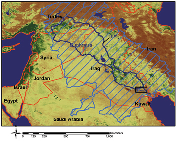
In this regional view, processed color composite image of weather satellite
data (AVHRR) acquired in January 1996 give a different perspective of
vegetation over Iraq and surrounding countries. Shades of green indicate
areas covered by vegetation; the areas in shades of yellow are deserts;
and shades of brown show highlands covered by snow. The figure also shows
the extent of the watershed that feeds these rivers (hachured in blue).
Image courtesy of Mohamed Sultan.
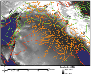
Shown here is the distribution of
rainfall over the highlands within the watershed. Average annual rainfall
is shown by green contours; elevation is shown in shades of gray; and
the watershed is defined by the stream network, which is shown in shades
of orange. Image courtesy of Mohamed Sultan.
|
According to the World Water Development Report, total renewable water resources
available per capita per year in Iraq amount to 3,287 cubic meters. This does
not put Iraq in the league of the water-rich countries in North America and
Western Europe that receive 10,000 cubic meters or more of water per capita
per year. However, Iraq’s renewable water resources are abundant when compared
to other neighboring countries, including the Gulf states, Israel, Jordan and
the Palestinian Territory; most of these regions fall short of 500 cubic meters
of water per capita per year.
Iraq’s relatively plentiful water resources have distinguished its landscape
from its more arid desert surroundings, making Iraq a lush forest when compared
with many of its neighbors. The precipitation over the watershed that feeds
the Euphrates and the Tigris rivers largely falls over the mountainous areas
in the northern, northeastern and eastern highlands in Turkey, Iraq and Iran.
The headwater catchment generating the Tigris and Euphrates is extremely high
in elevation, with the source area for the Euphrates near Lake Van in Turkey
reaching elevations of 4,500 meters (14,674 feet). The sources of the Euphrates
originate almost exclusively in the highlands of Turkey. The sources for the
Tigris, however, are distributed throughout Turkey, Iran and Iraq. Downstream,
the picture is different; the land is extremely flat, falling in elevation only
a few centimeters per kilometer, which gives rise to meandering channels and
eventually to marshlands.
The landscape of Iraq has endured many changes over the past few decades. The
areas occupied by the marshlands have been affected most, with the largest changes
occurring in the 1990s. In general, the marshlands have been on the decline,
in some cases replaced by arable lands; in others, however, they have unfortunately
been transformed into desiccated salinized land. Until the 1970s, the Mesopotamian
marshlands extended over an area of 15,000 to 20,000 square kilometers in central
and southern Iraq. Today, the Central and Al Hammar marshlands have almost entirely
disappeared — vegetated land cover has been transformed into barren land
and salt crusts. Only one-third of the Hawr Al Hawizeh marshlands remain (see
Geotimes, this issue).
These observed land-cover and land-use changes over the Mesopotamian marshes
mostly reflect the impacts of large engineering projects on the hydrology of
the Tigris-Euphrates basin. Iraq and its upstream neighboring countries have
implemented these projects. Iraq had plans to develop drainage systems that
would discharge saline runoff from irrigated agricultural lands to the sea —
waters that would drain into the marshes and increased their salinity. However,
that project somehow evolved into efforts aimed at developing agricultural lands
at the expense of the marshlands.
 Although the
construction of these projects began in the 1970s, Iraq didn’t embark on
its marshland-draining project until the end of the 1991 Gulf War. There have
been speculations about the true motivation behind the implementation of the
project because the drained marshlands remain largely uncultivated. Some have
suggested that Saddam Hussein developed the project to punish the population
in the south that started an uprising against his regime in 1991. The degradation
of the marshlands has led to the migration of an estimated half-million Marsh
Arabs and has devastated the biodiversity and wildlife there as well. Any future
water-management schemes should have a strong component dedicated to the partial
restoration of the marshlands.
Although the
construction of these projects began in the 1970s, Iraq didn’t embark on
its marshland-draining project until the end of the 1991 Gulf War. There have
been speculations about the true motivation behind the implementation of the
project because the drained marshlands remain largely uncultivated. Some have
suggested that Saddam Hussein developed the project to punish the population
in the south that started an uprising against his regime in 1991. The degradation
of the marshlands has led to the migration of an estimated half-million Marsh
Arabs and has devastated the biodiversity and wildlife there as well. Any future
water-management schemes should have a strong component dedicated to the partial
restoration of the marshlands.
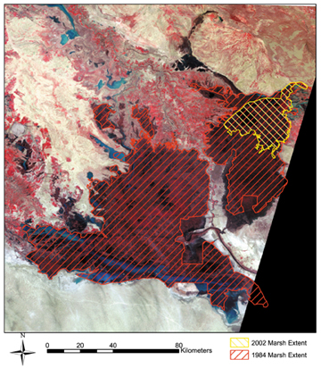
The decline in the area occupied by the
marshlands throughout the past three decades is apparent in these images. Marshlands
appear as dark areas on the 1977 Multispectral Scanner (MSS) satellite image.
The aerial extent of the marshes in 1984 and 2002 were extracted from temporal
satellite, Landsat, data and were plotted for comparison on the 1977 image.
Image courtesy of Mohamed Sultan.
In addition to the drainage systems, dams were also responsible for the devastation
of the marshlands. Countries sharing the Tigris-Euphrates watershed, namely
Turkey, Iraq, Iran and Syria, have constructed more than 30 major dams to store
water and to tame the flow of the Tigris and Euphrates rivers. Around the same
time the Iraqis were embarking on the construction of the marsh-drainage canal
system, damming projects were accelerating in the region. For example, in 1989,
Turkey launched an integrated regional development project that would develop
a series of dams upstream on both the Euphrates and the Tigris, potentially
reducing the flow of the Euphrates in Iraq by as much as 80 percent and in Syria
by 40 percent. Both Syria and Iraq threatened to go to war over their access
to Euphrates waters. To date, a regional water-sharing agreement has not been
reached, and the need for reaching such an agreement is heightening, as water
shortages likely will become more acute with time.
The political conflicts and disputes, escalating wars, and ever-shifting alliances
have derailed previous attempts to reach equitable reconciliation schemes. Only
limited guidelines in international law exist today to regulate the trans-boundary
rivers and to define the rights and obligations of riparian states. We hope
that the postwar conditions and new political systems in place can provide the
atmosphere of stability that is required to conduct the lengthy and difficult
negotiations that are needed to reach such agreements. With more than 90 percent
of Iraq’s available water resources used for agricultural purposes, such
water-sharing agreements would affect the agricultural sector the most.
The vegetated areas are largely concentrated in central Iraq, where the marshlands
are located, and in the northeast as well. Currently, a large portion of the
vegetated lands are farmlands, which cover approximately one-fifth of Iraq’s
territory; they are sub-equally divided in aerial extent between rain-fed farmlands
in the northeast and the valleys of the Euphrates and the Tigris. Under the
centrally controlled agricultural system that Saddam Hussein had in place, the
government controlled the prices of agricultural products, and farmers had little
incentive to increase productivity. They also did not have adequate access to
modern resources, such as machinery and irrigation equipment, fertilizers, pesticides,
and appropriate (for example, saline-resistant) feedstock.
Currently, excessive use of water for irrigation is a common practice because
water use is not modernized; such practices in warm countries such as Iraq promote
salinization of soils, a problem acknowledged, but not addressed on a regional
scale, by the previous administration. Regardless of the outcome of any negotiations
with its neighbors pertaining to water allocations, Iraq should exert efforts
and resources to evaluate and develop alternative water resources. Examples
of these alternative resources include groundwater and nonconventional water
resources (for example, recycling wastewater and desalinizing brackish waters).
Iraq should also develop nationwide programs to modernize water usage perhaps
by adopting water pricing and by implementing modern and efficient irrigation
systems.
In this part of the world, political realities have cast deep shadows over the
environmental arena. The approval of a country’s political system in the
Middle East is generally needed for large engineering and environmental projects
to proceed. Currently, the identification of these projects and the timing of
their implementation are not driven by balanced social, economic, environmental
and scientific factors, but rather by decisions made on the highest political
levels with or without the support of the scientific community. Iraq has not
been any different. As the country embarks on a new era of political freedom,
it hopefully can provide an example to neighboring nations of how to replace
the status quo with progressive and dynamic water-management schemes —
implemented on a solid scientific, economic, societal and environmental basis.
Sultan is a professor in the
Department of Geology at the University at Buffalo (UB), SUNY, and he is the director
of the Earth Sciences Remote Sensing (ESRS) facility. Becker is a senior research
scientist at UB’s ESRS. Al-Dousari is a senior research scientist at Kuwait
Institute for Scientific Research. Al-Ghadban is the manager of Environmental
Sciences Department at the Kuwait Institute for Scientific Research. Bufano is
a research scientist at ESRS.
Links
"Iraq's
Marshes Renewed," Geotimes, October 2003
Back to top
