Geotimes

Geophenomena
New addition to the Aleutian family
Yellowstone geysers heat up
First dead zone forecast
New
addition to the Aleutian family
 While
searching for deep-sea corals on the ocean floor near the Aleutian Islands,
researchers instead found Alaska’s first known active underwater volcano.
While
searching for deep-sea corals on the ocean floor near the Aleutian Islands,
researchers instead found Alaska’s first known active underwater volcano.
A biological expedition run by NOAA’s National Marine Fisheries Service
first sighted the infant cone in June 2002. Not until June of this year did
a team led by Jennifer Reynolds, a marine geologist at University of Alaska
Fairbanks, map the structure in detail using multi-beam sonar.
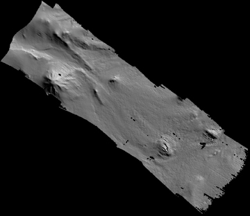
Multibeam sonar data provide a map of the Alaskan seafloor and a new-found submarine
volcano (upper left), surrounded by a field of lava flows. Image courtesy Jennifer
Reynolds.
They discovered a peak 580 meters (1,903 feet) tall with a 4-kilometer-wide
base (one-third to one-half the height of nearby on-land volcanoes), as well
as a volcanic lava field extending over 14 kilometers. As part of an island
arc formed by a subduction zone, this young volcano is probably prone to explosive
eruptive events — which means it poses a potential threat to passing vessels
because of its proximity to the ocean’s surface, only 115 meters (377 feet)
below sea level.
The Alaska Volcano Observatory already has plans to put a seismic monitor on
a nearby island by 2005. Reynolds will join an expedition next summer to look
more carefully at the newfound volcano. “We really know just a little bit
about this volcano,” Reynolds says. Though it apparently was active within
the past millennium, she says, “we don’t know whether that means 50
years ago or 800 years ago.”
Naomi Lubick
Back to top
Yellowstone
geysers heat up
Since July 23, some trails within the Norris Geyser Basin in northern Yellowstone
National Park have been closed to visitors due to high ground temperatures and
increased thermal activity that could affect visitor and employee safety. To identify
the sources and explain the increased activity, and to gauge any risks of seismic
activity or hydrothermal explosions, geologists are fitting the Back Basin at
Norris with a series of new instruments, making it the most heavily monitored
geyser basin in the world.
 The increased thermal
activity includes the formation of new mud pots, greater turbidity of thermal
pools, increased steam discharge, and changes in geyser eruption intervals and
output. Ground temperatures can reach up to 100 degrees Fahrenheit above normal,
and vegetation dies from the high temperatures.
The increased thermal
activity includes the formation of new mud pots, greater turbidity of thermal
pools, increased steam discharge, and changes in geyser eruption intervals and
output. Ground temperatures can reach up to 100 degrees Fahrenheit above normal,
and vegetation dies from the high temperatures.
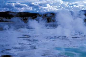
Geysers and thermal waters in Yellowstone
National Park, where geologists have fitted the Back Basin at Norris Geyser with
instruments to observe increased thermal activity. Photo by Bruce Molnia, Terra
Photographics.
In August, scientists with the Yellowstone Volcano Observatory
(YVO) responded to these dramatic changes by equipping the basin with a network
of seismographs, GPS receivers and thermometers. YVO is an instrument-based monitoring
facility run by the U.S. Geological Survey (USGS), the University of Utah and
the National Park Service.
“Never before has a geyser basin been observed in this way,” says Jacob
Lowenstern, the USGS lead scientist at Yellowstone Volcano Observatory. “We
want to look at the geophysical and thermal data and to understand the day-to-day
activities in the geyser basin.”
The GPS sensors will detect any small movements or ground deformation. Seven new
broadband seismometers will detect long-period seismic activity, such as vibrations
due to water or gas movement through underground cracks or deeper volcanic sources.
Thermometers will continuously document pulses of water out of individual pools,
which may be tied to signals measured by the GPS receivers and seismometers. The
Integrated Research Institutes in Seismology and the University NAVSTAR Consortium
are also helping to provide equipment and technical support.
In addition to observing the daily activity of geyser basins, scientists are also
hoping to detect any precursory activity should a hydrothermal explosion occur.
Hydrothermal explosions are fairly common in the park, occurring roughly once
per year; however, they tend to be small and usually go unwitnessed. Therefore,
geologists know little about predicting them. “If anything does occur in
this case, it will be a great opportunity to learn about what precedes the explosions,”
Lowenstern says.
Yellowstone is a dynamic environment. Each summer, there is a noticeable increase
in the steam discharge and a change in color of many geysers and thermal pools
in the Norris Geyser Basin that is apparently related to the increased emission
of deep, hot waters. But this year, that annual disturbance is larger than normal.
Lowenstern says, “there is lots of new activity, and steam is finding its
way to the surface in places it never has.”
Still, scientists at the observatory caution that the increased activity doesn’t
necessarily indicate a greater probability of an impending hydrothermal explosion.
The last large hydrothermal explosion at Norris was the Porkchop Geyser explosion
in 1989, which tossed meter-sized boulders into the air. Porkchop remained silent
until this past July, when it began erupting water again.
Norris’ Back Basin will remain closed to the public as long as ground temperatures
and steam vents remain a risk. As of Aug. 15, researchers planned to keep the
monitoring instruments in place until the trails reopen — at least a month
— to allow the scientists time to study the data and to learn more about
hydrothermal activities.
Megan Sever
Links:
Yellowstone
Volcano Observatory
Yellowstone
National Park
Back to top
First
dead zone forecast
 Each summer, an
oxygen-depleted area up to twice the size of the Chesapeake Bay forms on the continental
shelf in the Gulf of Mexico — wreaking havoc on the Gulf fishing industry.
The size varies from year to year, only revealing its extent during the event
itself. Now, oceanographers have developed a model that, for the first time, predicts
the size of this so-called dead zone off the coasts of Texas and Louisiana. The
model couples nutrient and discharge data recorded in the Mississippi and Atchafalaya
rivers during the spring with an advection factor that accounts for variable Gulf
currents to predict the eventual size of the oxygen-depleted area.
Each summer, an
oxygen-depleted area up to twice the size of the Chesapeake Bay forms on the continental
shelf in the Gulf of Mexico — wreaking havoc on the Gulf fishing industry.
The size varies from year to year, only revealing its extent during the event
itself. Now, oceanographers have developed a model that, for the first time, predicts
the size of this so-called dead zone off the coasts of Texas and Louisiana. The
model couples nutrient and discharge data recorded in the Mississippi and Atchafalaya
rivers during the spring with an advection factor that accounts for variable Gulf
currents to predict the eventual size of the oxygen-depleted area.
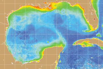
Chlorophyll-a is a proxy for phytoplankton
biomass. This 2003 image shows the pattern of chlorophyll and biomass in late
spring, just prior to the appearance of the dead zone. The area of high biomass
is typical for this time of year. The smaller size of the dead zone in 2003 is
likely due to tropical storms and not changes in nutrient input or total biomass.
Satellite image courtesy of NOAA.
“The combination of the nutrient load and the advection term explains 88
percent of the year-to-year variation,” says Don Scavia, the chief scientist
of NOAA’s National Ocean Service.
Along with researchers from the Louisiana Universities Marine Consortium and Louisiana
State University, Scavia also reports in the May Limnology and Oceanography
that the model shows the phenomenon is relatively recent and that efforts
to stem it may prove more difficult than previously thought.
However, the successful modeling of the dead zone’s range shows that researchers
have a solid understanding of the science that underlies the event. “It gives
us a little more confidence that we know how it is working — what makes it
form and dissipate every year,” says co-author Gene Turner, a biological
oceanographer at Louisiana State University.
The dead zone begins to form in spring and early summer when meltwater joins nutrient-laden
runoff from the agriculturally dominated watershed. When it flows into the colder,
saltier Gulf, this less dense water forms a surface layer where, with abundant
nutrients, algae flourish. “It’s like pea soup out there,” Turner
says. When the algae die and sink, oxygen-consuming decay begins and any bottom-dwelling
organisms that can’t escape the vast area die (hence the name, dead zone).
The cycle continues until temperatures cool and winds pick up in the fall, allowing
the layers to mix; tropical storms and hurricanes could mix the layers earlier.
Understanding how nutrient loads affect this cycle is essential to policy decisions
being made about future land use in the watershed. The Mississippi River drains
41 percent of the contiguous United States, an area with abundant fertilizer inputs.
Land-use changes in the watershed over the last 50 years have nearly tripled the
amount of nitrogen delivered to the Gulf. More than half the estuaries in the
United States are now faced with the problem of coastal eutrophication.
Although oxygen depletion, known as hypoxia, has been forming on the Gulf shelf
for more than three decades, researchers only began to systematically monitor
it in 1985. But using historic river nutrient data, Scavia’s team was able
to use the model to “hindcast” the size of hypoxic events going back
to 1968.
“The model confirms that the hypoxia was not very large, if present, decades
ago,” Turner says. “So that just reassures us again that this is a man-made
phenomenon. It’s not something that’s natural.”
According to the model, between 1985 and 1992, the hypoxic region averaged 8,300
square kilometers. Between 1993 and 2001 it rose to an average of 16,000 square
kilometers. The new model may help efforts to reduce that figure to less than
5,000 square kilometers by 2015, a goal set forth by the 2001 Mississippi River/Gulf
of Mexico Watershed Nutrient Task Force. Achieving that goal will likely require
a 30 percent reduction in nutrient loading. Model scenarios, however, suggest
that loads may need to be reduced by up to 45 percent to meet the target in some
years.
“We’re just offering a caution,” Turner stresses. “The model
is good to a certain level of prediction, but there may be other things that happen.
For example, climate change may alter the discharge of the river.”
Although the model successfully explains a lot of the variability in the size
of the zone from year to year, what it cannot predict is severe weather. In late
June and early July of this year, two storms — Tropical Storm Bill and Hurricane
Claudette — swept through the Gulf, disrupting the stratification. A monitoring
cruise in late July found the dead zone to be 8,560 square kilometers, about 6,000
square kilometers less than predicted. However, researchers expect that stratification
will return and the zone will enlarge before it finally dissipates in the fall.
Sara Pratt
Geotimes contributing writer
Back to top
