Geotimes

Technology
Earthquake warning tools
Josh Chamot
For as long as earthquakes have been a part of human history, the ability to
forecast a seismic event has been an elusive goal. Factors leading up to an
earthquake are incredibly complex and not yet completely understood; hence,
no reliable forecast method exists.
“Forecasting is considered a very hard problem,” says Kate Hutton,
a seismologist at Caltech. But she and other researchers are accepting the challenge
and are using recent advances in seismic and computational technology to attempt
to decipher Earth’s subtle clues. They are not seeking to predict, but
rather to provide enough early warning to prevent fatalities through a number
of emerging technologies.
 By simulating
fault systems and analyzing motion on the finest scales, earthquake researchers
hope not only to learn more about motions in the planet’s crust and mantle,
but also to see initial hints or patterns that could reveal a pending tectonic
event. In the future, data resolution will be so high that monitoring sensors
may be able to rapidly assess damage and the location of greatest impact —
all at a speed necessary to direct an emergency response.
By simulating
fault systems and analyzing motion on the finest scales, earthquake researchers
hope not only to learn more about motions in the planet’s crust and mantle,
but also to see initial hints or patterns that could reveal a pending tectonic
event. In the future, data resolution will be so high that monitoring sensors
may be able to rapidly assess damage and the location of greatest impact —
all at a speed necessary to direct an emergency response.
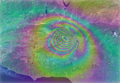
Simulation of deformation of the Earth’s
surface 500 years after the 1994 Northridge earthquake, generated by GeoFEST,
one of the QuakeSim simulation tools under development. Deformation is represented
as color fringes with each fringe representing elevation changes of 5.6 centimeters.
Federal agencies and universities have conceived a number of integrated simulation
and monitoring programs, and several of the largest are now coming online or
evolving to new levels. Three major initiatives demonstrate this trend on three
different levels: QuakeSim, principally managed by NASA’s Jet Propulsion
Laboratory at Caltech and researchers at several universities, is a large-scale
earthquake modeling and simulation program; TriNet, a collaborative effort between
Caltech, the U.S. Geological Survey (USGS) and the California Geological Survey
(CGS), is a local earthquake monitoring network; and the USGS Advanced National
Seismic System (ANSS) is a national earthquake monitoring network.
Simulation
Using data gathered through ground- and space-based measurements and high-powered
grid computing systems, QuakeSim is a computer modeling system that will help
researchers better understand the processes that lead up to earthquakes and
aftershocks. QuakeSim does not forecast, but instead is a way to bring technology
to bear on the complexity of earthquakes and other tectonic processes, including
volcanism. The system’s models may also reveal the patterns that emerge
before, during and after main events.
“The objective of QuakeSim is to understand the earthquake process through
integration of models of different scales,” says Andrea Donnellan of the
NASA Jet Propulsion Laboratory, who is principal investigator for the project.
“We are focusing on using long-term deformation data to model the process,”
with researchers able to access the information via the Web, she says.
The source data include information from space-derived GPS and InSAR data, as
well as land-based laboratory and field geologic data. The resulting simulation
has three computer tool components — PARK, GeoFEST, and Virtual California
— each producing results that should be compatible with many existing and
future research initiatives. Although QuakeSim is still a work in progress,
its programmers have tested the performance of all three programs and devised
strategies for how the programs will work together to model earthquake dynamics.
They have also begun developing a framework for making the data accessible to
numerous researchers at distant locations.
When complete, geophysicists and modelers will use PARK to study fault slip
on several spatial and temporal scales at the heavily researched Parkfield segment
of the San Andreas fault in California. They will be able to observe the entire
earthquake life cycle, analyzing slip (including non-quake motions), slip history
and stress at a given point along a fault, while simultaneously incorporating
information about every other point — potentially revealing earthquake
warning signals. To digest the complicated algorithms, 1,024 computer processors
will work together in parallel.
Complementing the data from PARK, GeoFEST will model the evolution of stress
and strain in a detailed simulation of the crust and mantle, potentially helping
researchers predict the deformation from an earthquake or a series of quakes.
The results are 2-D and 3-D models, eventually capable of analyzing much of
the Southern California fault system, an area roughly 1,000 kilometers (621
miles) on a side.
The third QuakeSim tool, Virtual California, will simulate interactions between
hundreds of faults, ultimately correlating factors that may predict large earthquakes,
particularly events of magnitude 6.0 or greater. Large earthquakes are capable
of rupturing multiple fault systems. Modelers can correlate the simulations
to real data, and they are already putting this tool to the test. Geophysicists
used Virtual California to predict the regions of the state with elevated quake
probabilities. Since 2000, all of the region’s earthquakes of magnitude
5.0 or greater occurred within 6.8 kilometers of predicted sites.
Knowledge gained from QuakeSim may help refine the results of TriNet and ANSS,
two systems already processing enormous amounts of data.
Local monitoring
Southern California experiences nearly 30 earthquakes every day. While most
quakes are not severe, the seismic activity provides a vibrant monitoring environment.
Funded since 1997, TriNet is an attempt to create an advanced real-time earthquake
information system for Southern California; it is now part of the larger California
Integrated Seismic Network (CISN).
The biggest current development for TriNet is its participation in CISN, says
Hutton, a member of the TriNet team. They are merging the data from several
of the largest seismic networks into a common database. “Besides making
the data more easily accessible to researchers and users, it also makes it possible
for northern California to back up southern California, and vice versa, in the
case of a really big one,” she explains.
TriNet built on the existing Southern California Seismic Network, a configuration
of more than 200 seismic monitoring stations that have been operated since the
1960s by Caltech and USGS. TriNet brought the network up to speed with the addition
of digital instruments and real-time processing and transmission. CGS has been
upgrading strong-motion monitoring systems at 400 sites in the California Strong
Motion Instrumentation Program, and USGS has been upgrading the 35 Southern
California-based sensors that are part of the network of 571 in the National
Strong Motion Program.
The data from all sensors travel to a central processing facility at Caltech
via digital phone lines, radio, microwave links and the Internet. Researchers
immediately analyze the data to determine where the quake occurred, its size,
the distribution of the shaking and the specific fault. Scientists participating
in CISN are wired to the system through paging and Internet, with Web access
to high-quality, high-density research data for long-term research projects.
TriNet utilizes two types of seismometers: strong-motion accelerometers collect
ground motion data in violently shaken areas for seismological and engineering
data, and broadband seismometers record small and large seismic events.
Seismic monitoring stations collect data in both analog and digital formats.
Analog stations pass information via telephone lines and computer processors
at the processing center where data are converted into digital information.
However, the electronics and phone lines have a limited information range, so
data can go off the scale and get lost. Still, analog stations are easier to
maintain because they are simpler, and much of the hardware is at the central
processing center.
Digital stations have both high- and low-gain sensors, which allow data to stay
in scale no matter how large or small. They use 24-bit digitizers to convert
motion into a digital signal on site and send information via digital link to
the central processing station for immediate use. The benefit of digital is
that it can provide information for small and large quakes, and researchers
can check the data for error, confirming that line noise has not corrupted any
of the information.
In total, TriNet incorporates 150 broadband sensors, 600 strong-motion sensors
and a central processing system designed to function at least in part if an
earthquake occurs in the vicinity. The data will yield an earthquake catalog
for activity at magnitude 1.8 and above, rapid descriptions of the events, a
ground motion database for greater than magnitude-4.0 events, frequency-dependent
ground motion maps, and integrated map data called ShakeMaps — automatically
generated maps that show ground-shaking intensity. Such products provide assistance
to the government, fire and rescue teams, utility companies, and the media so
that they can all respond to an earthquake crisis. But TriNet could perhaps
go a step further — to early warning.
“TriNet is on the cutting edge of seismicity monitoring,” Hutton says.
“Through modern computer and communications technology, seismic stations
close to the epicenter of a big quake warn that the P and S waves are actually
on the way.”
This type of early warning could provide several tens of seconds of notice before
a quake hits a given area — perhaps long enough to implement some responses
and allow people to secure their immediate surroundings. Using CISN stations,
the Pilot Seismic Computerized Alert Network will be able to recognize when
an earthquake outside of a populated area is in progress and send notification
to scientists and emergency personnel in nearby residential areas before shaking
arrives.
National monitoring
TriNet has provided researchers with new ideas to take to the national level.
When complete, the USGS will network 7,000 sites on the ground and in monitored
buildings at sites across the nation with ANSS — providing emergency personnel
with real-time information and recording scientific and engineering datasets
for both geological and engineering research.
“This system will upgrade our current monitoring capabilities through the
installation of new instrumentation and the integration of existing monitoring
efforts,” says Paul Earle, a research geophysicist at the USGS National
Earthquake Information Center. “ANSS will provide emergency response agencies
with information about the intensity of shaking and engineers with data to design
better buildings.” Scientists working to understand earthquake physics
can also use the data to improve forecasting abilities. “Earthquake monitoring
impacts many aspects of seismology and public safety beyond earthquake forecasting,”
he says.
In scope and scale, “ANSS is the authoritative seismic monitoring system
for the U.S.,” says Mitch Withers, research associate professor at the
Center for Earthquake Research and Information (CERI) at the University of Memphis.
ANSS goes beyond California, reaching Alaska, Hawaii, Puerto Rico and the continental
interior. Regional centers across the country will link the monitoring network
to local institutions. For example, the mid-America regional processing center
at CERI links university partners from Missouri to Virginia and processes more
than 700 data channels. Institutions exchange data in near real-time, although
current automated earthquake information is only available for the active part
of the New Madrid seismic zone.
“Given recent developments by the USGS, we are working to provide this
information for the entire region. The ANSS philosophy is to provide information
as quickly and reliably as possible and to continuously improve and reduce the
necessary [warning] time,” Withers says.
ANSS works on a tiered system in which unstaffed computers feed data to regional
processing centers, which in turn feed the national center. The regional and
national centers act as backups to each other, and local experts guide the process.
According to Withers, existing systems use multi-station procedures to produce
alarms for broad regions, although critical facilities use single-station triggers.
“Research is ongoing within the seismology community to develop faster
algorithms with reduced data requirements,” Withers says. However, implementing
such algorithms is difficult, he says. “Early warning is conceptually quite
simple but nontrivial to implement reliably and without false alarms.”
In addition to the variety of data outputs, the information will yield additional
ShakeMaps, which are now active in California, Seattle and Salt Lake City, and
soon to come in Anchorage. Planners hope that ANSS will organize, modernize,
standardize and stabilize seismic monitoring in this country. The program, however,
is currently funded at only 10 percent of the approximately $150 million the
U.S. Congress authorized in 1999. If full funding is secured, researchers will
install 6,000 new instruments in urban networks, 1,000 in regional networks,
and 44 in minimal-risk areas to complete a national monitoring net. Two portable
25-station arrays will study aftershocks and earthquake hazards directly at
active sites, although permanent stations will conduct the bulk of monitoring
duties.
Despite myriad earthquake monitoring projects, these technologies can only go
so far. “Still, the best way to save lives and property,” Earle says,
“is to be prepared for an earthquake by building better structures and
having a quick and reliable emergency response system in place.”
Chamot is a freelance writer
based outside of Washington, D.C., and a frequent contributor to Geotimes.
