
 At the outset
of a building project, the primary consideration is the foundation of the proposed
structure. Similarly, Earth is the primary foundation upon which we build our
communities, and understanding the planet’s characteristics is essential
to building a stable and durable society. Geologic mapping helps us understand
the composition and distribution of Earth’s surficial materials and determine
how our decisions will impact our environmental, societal and economic future.
At the outset
of a building project, the primary consideration is the foundation of the proposed
structure. Similarly, Earth is the primary foundation upon which we build our
communities, and understanding the planet’s characteristics is essential
to building a stable and durable society. Geologic mapping helps us understand
the composition and distribution of Earth’s surficial materials and determine
how our decisions will impact our environmental, societal and economic future.
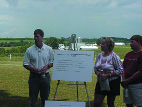
In Democrat Rep. Ron Kinds (shown here
at left) home district in Wisconsin, farmers use geologic maps to plan cultivation
strategies, devise crop rotations and ensure the health of their animals. Recognizing
the diverse roles mapping plays in society, Congress recently voted to reauthorize
the National Geologic Mapping Act. Image courtesy of the Office of Congressman
Ron Kind.
Geologists and engineers have long used maps to convey or decipher information
about Earth’s surface. But recent advances in digital technology led to
the development of geologic map data in formats that can be used by the public
at all levels to assist in analysis and decision-making — and have greatly
changed the toolbox of urban and rural planners. Perhaps if the original Venetian
architects, for example, had access to modern geological mapping data, they
would have been able to circumvent the modern city’s sinking fate.
While the mapping of geologic features is certainly not a new concept, it is
only recently that there has been a coordinated effort between the U.S. federal
government, state agencies and academia to generate this valuable data. The
National Geologic Mapping Act of 1992 established the National Cooperative Geologic
Mapping Program to implement and coordinate an expanded geologic mapping effort
by the U.S. Geological Survey, state geological surveys and universities to
address issues of greatest relevance to the public.
The legislation has led to the creation of a National Geologic Map Database,
which provides a catalog of reliable paper and digital maps and is easily accessible
to a wide range of users. Federal and state survey efforts have produced more
than 7,500 new geologic maps that have been put to good use for a variety of
purposes, from exploring energy resources to city planning. To date, however,
less than one-third of the United States has been geologically mapped at the
scale necessary to make decisions on land and water use.
As a representative of a rural area in western Wisconsin that is heavily populated
with family farms, I have heard how farmers use geologic maps to plan cultivation
strategies, devise crop rotations and ensure the health of their animals. I
can speak personally to the power of the information provided through geologic
mapping, having relied heavily on such data to understand the composition and
structure of the land on my own farm.
With emerging technologies and digital mapping, the volume of collected, archived
and distributed data in the National Geologic Map Database is growing exponentially
and so is the applicability of the information. Currently, geologic mapping
data are used in locating energy resources, economic and community development,
land and natural resource management and conservation, ensuring public safety
during times of both natural (wildfires, floods, earthquakes) and human-induced
disasters, and form the foundation for studying and solving geographically based
problems.
Geologic mapping data have also proved highly useful for protecting the homeland,
assessing geologic hazards and understanding global climate change. The data
also serve in assessing our vulnerabilities to biochemical attacks on our energy
and water supply. Thus with a sharp focus on domestic security, Congress has
turned to the National Cooperative Geologic Mapping Program to enhance emergency
preparedness.
On July 14, the House Resources Committee voted to reauthorize the National
Geologic Mapping Act (H.R. 4010). This bill authorizes appropriations for the
program at the existing 2005 level of $64 million a year for fiscal years 2006
through 2010. The Senate must pass companion legislation, and the goal is to
send the reauthorization bill to the president’s desk this year. The legislation
extends the deadline for development of a five-year strategic plan for the program.
Just as road maps are invaluable resources for efficiently navigating through
our physical environment, geologic maps are useful in evaluating the direction
of our decisions and in determining sound public policy. We must continue to
support the goals outlined in the National Geologic Mapping Act and be conscious
of the fact that the planet that lies beneath us is our primary foundation.
 |
Geotimes Home | AGI Home | Information Services | Geoscience Education | Public Policy | Programs | Publications | Careers |