
On a recent trip to Kabul to meet with the U.S. Geological Survey (USGS) and
to check on reconstruction progress, I was impressed to find the city jam-packed
with returned refugees and legions of country people who have come to the city,
where at least slightly greater security exists for them. The bombed-out, wrecked
city, where garbage was not cleaned up for over a decade, is now a fetid swamp
of humanity, with a new rush-hour-traffic snarl of SUVs and trucks belching
diesel exhaust at gridlock proportions. New buildings are springing up everywhere
as the war rubble is cleared away, and the people of the city contemplate hope
for a real future once again.
Kabul
University, a green haven in the storm of destruction around it, is filled with
students once again, with only a few veiled figures visible; instead, the old
pre-war freedom of unveiled women was evidenced everywhere on campus when I
visited. The few faculty of the English department have as many as 700 majors
eager to learn the new language of power and education in the city. The geosciences
department once again has an association with the government of Germany, who
mapped much of the southern two-thirds of the country before the Soviet invasion
of 1979 and subsequent wars until 2002.
Accompanying these massive changes in Kabul over the past year, and since my
last Geotimes column a year ago (October 2003),
was the discovery by the media that some of the funding for reconstructing Afghanistan
was diverted to the war in Iraq. The United States seems to be muddling along
on its several fronts, not accomplishing nearly as much as it could, but not
exactly failing either.
Under the scrutiny of Washington, some American bureaucrats in Kabul are experiencing
micromanagement pressures for performance in this election year. For example,
a top White House official is reported to have been calling the U.S. Agency
for International Development (USAID) in Kabul as many as three times a week
to track progress on such activities as how many kilometers of road are fixed
or how many irrigation canals are cleaned. Other officials in Afghanistan have
complained that far too many decisions seemed to be based on politics rather
than on how well they would help Afghanistan. Nevertheless, however halting
or fitful our reconstruction efforts in Afghanistan might now be, USGS efforts
there at last are partially funded. Thus, geoscientists are able to undertake
a concerted program of resource development, just as I have been advocating
in my publications for well over a decade.
Green
light
Last year, more than 1,000 nongovernmental organizations (NGOs) were reported
to be in Afghanistan to offer assistance in redevelopment. Aside from the rampant
inflation caused by the high salaries, expensive vehicles and the best housing
going to the NGOs, their efforts still seem to be making progress. About 20
nations have contributed troops to Operation Enduring Freedom in the ongoing
U.S.-led military campaign against Taliban and their ilk. Thirty-one additional
nations are participating in the International Security Assistance Force coalition
that seems to be calming down the urban areas little by little, at least in
theory.
 The
provincial reconstruction teams mounted by the U.S. and British armies do concern
some of the NGOs, who see a worrisome blurring of military and humanitarian
lines that they fear will increase their vulnerability. Maintaining security
for NGOs in Afghanistan is indeed a problem in these delicate times. Geological
fieldwork has been possible for a few people, but only with a full security
detail to guard life and limb.
The
provincial reconstruction teams mounted by the U.S. and British armies do concern
some of the NGOs, who see a worrisome blurring of military and humanitarian
lines that they fear will increase their vulnerability. Maintaining security
for NGOs in Afghanistan is indeed a problem in these delicate times. Geological
fieldwork has been possible for a few people, but only with a full security
detail to guard life and limb.
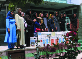
A group of 12 Afghan female teachers just
returned to Kabul from Nebraska with their new computers and printers.
Efforts by USGS to study the resources of Afghanistan that are necessary to
help boost its economy have been far from straightforward since September 11,
but at last are now under way. Their efforts to obtain funding continued from
2002 into the first part of 2004.
After seemingly interminable negotiations and briefings, USAID finally funded
the oil and gas resources assessment nationwide. The total funding was about
$2 million for a 20- to 22-month effort. That funding agreement was not finalized
until this past March, but the work actually had begun in August and September
2003, with a trip by three USGS oil and gas specialists to Afghanistan.
In February, the USAID mission in Kabul decided to provide $5 million for six
months in 2004 to initiate a USGS study of earthquake hazards, geospatial infrastructure
development, mineral, coal and water resources, and capacity building or training.
Considering the needs of the country and that USGS initially asked for $70 million,
$5 million is a drop in the bucket, but at least it is a start.
To initiate the USGS activities, a team of nine USGS scientists headed by Jack
Medlin (from whom much of this information was obtained) traveled to Kabul during
the spring of 2004. The team included specialists in coal, minerals, earthquakes,
GIS, remote sensing and geologic mapping. The researchers spent more than two
weeks in Kabul visiting more than 15 Afghan government organizations, and several
development bank offices, NGOs and foreign donor organizations. They discussed
facilities, data and information availability, and the quality and quantity
of staff to work as counterparts to the foreign scientists. Several team members
and Afghan geologists actually visited mineral and coal deposits outside of
Kabul with heavily armed security escorts. This June, the scientists finalized
a detailed work plan with USAID to establish an ongoing USGS presence in Kabul.
On Jan. 31, Said Mirzad, who was the head of the Afghanistan Geological Survey
over 30 years ago before working for USGS in the United States, became the first
USGS employee assigned to U.S. Ambassador Zalmay Khalilzad’s staff in Kabul.
The new ambassador, who was also born in Afghanistan, asked Mirzad to become
his new senior advisor for natural resources. When I visited Mirzad at the heavily
fortified U.S. embassy in Kabul in late May, he wanted to know how soon we could
start educating Afghans in the English language and remedial geosciences after
their 25-year gap in training in modern geology, which was created by the long
years of war.
Mirzad’s request echoed some of my efforts over the past 30 years, since
the late Chris Jung and I first started the Afghanistan Studies Center at the
University of Nebraska at Omaha in 1972. While our activities in the country
over the years have been many and varied, they particularly have involved providing
education to a host of Afghan teachers, as well as publishing textbooks in Dari
and Pushtu, and reports on natural resources. Several years ago, USGS selected
our Complex Systems Lab as the Regional Center for Afghanistan and Pakistan
in their Global Land Ice Measurements from Space Project, which is funded by
NASA. We have regular access to the terabytes of ASTER satellite data from Afghanistan
that are actively pouring down from space to enable our assessments. Now, we
are negotiating a new contract for further analysis of glaciers, snow and ice,
water, hazards and education.
Managing information
In these efforts, the Afghan organizations that USGS will most likely be working
with the closest are the Ministry of Water, Irrigation and Environment, the
Department of Cartography and Geodesy, and the Afghanistan Geological Survey.
The ministry is in the best shape of these groups, as it has already started
the rebuilding and revitalization process, and their physical facilities are
in reasonable condition.
On the other hand, the Afghanistan Geological Survey is in a depressing shell
of a building with no electricity, plumbing, furniture or equipment. Electric
wires were even stripped out of walls for resale on the black market in Pakistan.
All the windows were blown out and are yet to be replaced.
 The
Department of Cartography and Geodesy has a workforce of about 700 and a building
that is intact. The problem, however, is that their equipment is of museum-age;
electronic technology has just passed them by. Tightly controlled by communist-era
officials in the 1970s, this agency regarded all large-scale maps as state secrets.
That attitude has propagated forward into the 21st century as well. So although
some secretive Afghan officials are reported to be disturbed about it, other
agencies have implemented more transparent means to access the data.
The
Department of Cartography and Geodesy has a workforce of about 700 and a building
that is intact. The problem, however, is that their equipment is of museum-age;
electronic technology has just passed them by. Tightly controlled by communist-era
officials in the 1970s, this agency regarded all large-scale maps as state secrets.
That attitude has propagated forward into the 21st century as well. So although
some secretive Afghan officials are reported to be disturbed about it, other
agencies have implemented more transparent means to access the data.
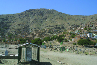
Low-cost housing without access to water
or sanitation lies on the Precambrian crystalline rocks that rise around the
Kabul Basin. The graveyard in the foreground is representative of a greatly
increased land use around Kabul in the past two decades of war.
Thus, in part to circumvent the difficulty of inadequate or secret maps and
other previously classified and unavailable information, the Afghanistan Information
Management Service and the Afghanistan Research Evaluation Unit were set up
with U.N. and USAID backing. The management service is actively producing high-quality,
GIS-based maps at many scales, with new computers and training programs in newly
configured labs, with software operating licenses from a major American GIS
firm. Its primary mandate is to build information management capacity among
the employees of the new government of Afghanistan — by providing training,
coordination, general advisory work and consulting. Five regional management
service offices have also been set up in the outlying cities of Jalalabad, Mazar-i-Sharif,
Kunduz, Herat and Kandahar. Geology maps will be a later addition, but right
now, Landsat-based terrain maps — with a variety of GIS overlays of political
boundaries, roads, trails, village names and landcover types — are available
at low cost or free to their sponsoring agencies. Later, after a number of years
have passed with no apparent adverse effect from such “subversive”
maps, some Afghan officials hope that perhaps the offices can evolve into a
quasi-governmental organization.
The evaluation unit was similarly set up as the best available library of materials
on reconstructing Afghanistan. Its foundation is most of the surviving library
of the British government that once ran the country’s foreign affairs,
with the exception of the once-comprehensive topographic map collection, which
seems to have disappeared. The huge and equally comprehensive development library
of USAID in Kabul, in the intervening quarter of a century since they were in
Afghanistan, also seems to have disappeared, jokingly it is said, into the same
dim warehouse of the U.S. government as that portrayed in the movie Indiana
Jones: Raiders of the Lost Ark.
Loya
jirga
Hopefully, these current activities will turn around Afghanistan, a country
with tragedy stretching decades into the past, with vast armies of many political
and religious persuasions gnawing at the bones of the nation. Now it is the
turn of the international coalitions to provide the forces necessary to keep
the peace.
Afghanistan is very far from the reasonably safe place to work that it once
was, when I drove and walked all over it with only my field counterpart and
translator for company 26 years ago. Still, with adequate precautions and sufficient
information about conditions, coupled with a security detail, geoscience fieldwork
is possible. Thus, in spite of the fitful start of U.S. resource assessment
noted in my Geotimes article last
year, analyses now under way may at long last be producing results that
will finally create the jobs and revenues to bring the country out of a dark
age. With the recent restoration of the loya jirga, or town-meeting type
of democracy for which Afghanistan was known, and the promulgation of a new
constitution, the country may at long last rejoin the company of civilized nations.
Keep your fingers crossed.
 |
Geotimes Home | AGI Home | Information Services | Geoscience Education | Public Policy | Programs | Publications | Careers |