
 Pressure measurements
on Oct. 19 placed Hurricane Wilma as the most intense hurricane ever recorded
over the Atlantic Ocean basin. Wilma dropped from a Category-5 to a Category-4
storm before its devastating landfall on Oct. 21 on the Yucatán Peninsula.
Florida residents hoped that it would continue to diminish before heading northeast
towards Florida, but the situation took a turn for the worse when Wilma regained
intensity over Gulf waters.
Pressure measurements
on Oct. 19 placed Hurricane Wilma as the most intense hurricane ever recorded
over the Atlantic Ocean basin. Wilma dropped from a Category-5 to a Category-4
storm before its devastating landfall on Oct. 21 on the Yucatán Peninsula.
Florida residents hoped that it would continue to diminish before heading northeast
towards Florida, but the situation took a turn for the worse when Wilma regained
intensity over Gulf waters.
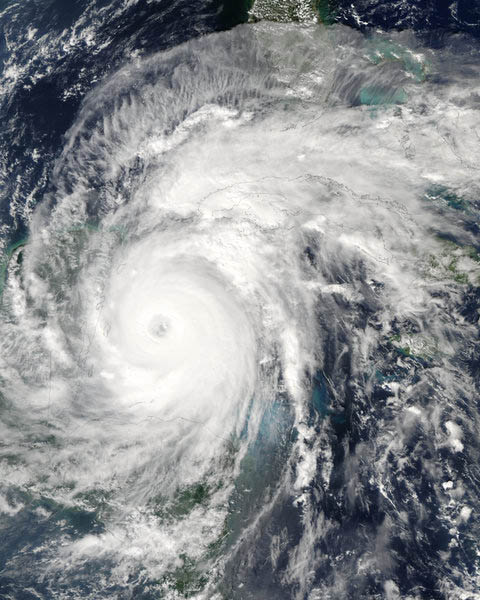
The NASA Aqua satellite
captured this image of Hurricane Wilma on Oct. 20 as it approached Mexico's
Yucatán Peninsula as a Category-4 storm. Wilma tops the National Oceanic
and Atmospheric Administration's list of the most intense North Atlantic hurricanes
(based on minimum pressure recorded) since measurements started in 1900.
Hurricane Wilma (the first "W" since naming storms began
in 1950) was not the only hurricane to follow this re-intensification pattern;
hurricanes Katrina and Rita also grew in strength over the Gulf of Mexico. The
onslaught of hurricanes this season has provided researchers with ample data
to study conditions in the Gulf that contribute to hurricane strength.
After passing the Yucatán and killing about 10 people, Hurricane Wilma
weakened and then strengthened again into a Category-3 storm in time for its
Oct. 24 landfall north of Everglades City, Fla., and resulted in the deaths
of about 10 more people. Sustained winds were recorded at 200 kilometers per
hour, which led to the loss of power for one-third of Florida residents, according
to the Associated Press story. Damages in the United States could range anywhere
from $2 billion to $9 billion.
The damaging strength of Wilma increased when it "ran over a thing called
the Loop Current," says Frank Lepore, spokesperson for the National Oceanic
and Atmospheric Administration (NOAA) National Hurricane Center. The Gulf Loop
Current connects theYucatán Current flowing into the Gulf of Mexico with
the Florida Current that flows out. Acting as the dominant clockwise circulation
pattern in the eastern Gulf of Mexico, the Loop Current spawns eddies that transfer
warm water around the Gulf, which researchers say helps hurricanes to strengthen.
The Gulf of Mexico is "like a big bathtub; it doesn't take much to heat
it up," Lepore says.
Warm eddies are more likely to destabilize and detach from the Loop Current
during hurricane season, said Nick Shay, a meteorologist and physical oceanographer
at the University of Miami in an Oct. 3 National Science Foundation (NSF) press
release. The difference this year, according to Shay, is the extent of the Loop
Current deep into the Gulf of Mexico. "A positive outcome of a hurricane
season like this is that we've been able to learn more about the Loop Current
and its associated warm-water eddies, which are basically hurricane intensity
engines," Shay said.
One week prior to Hurricane Rita, meteorologists from NOAA and the University
of Miami dropped instruments from an aircraft into the Gulf of Mexico that profiled
temperature and depths of currents. And two days before Rita, researchers from
NOAA and the Scripps Institution of Oceanography released "drifters"
that traveled with the Loop Current to measure temperature conditions in the
eddies.
Researchers at the University of Colorado in Boulder have compiled measurements
of sea-surface height, gathered by satellites, to map the Loop Current, according
to a University of Colorado Sept. 21 press release. They say that an elevated
height of the sea surfaces correlates to deeper warm water, which increases
the energy and intensity of hurricanes.
"We have long been aware that these currents are an important way for the
ocean to distribute heat and energy, but until now, we just didn't have much
data on the role they played in building hurricane intensity," Shay said
in the Oct. 3 press release. NSF's Division of Atmospheric Sciences funded the
NOAA and University of Miami research to help meteorologists predict the paths
and intensity changes of future hurricanes over the Gulf.
Kathryn Hansen
Links:
University
of Colorado, Boulder press release
National
Science Foundation press release
Associated
Press report
 |
Geotimes Home | AGI Home | Information Services | Geoscience Education | Public Policy | Programs | Publications | Careers |