geotimesheader
Geophenomena
| Cooking
Centralia: A recipe for disaster
It took the near death of a 12-year-old
boy in 1981 to garner international media attention. A 16-year-old cousin
rescued the child when the ground caved in beneath the young boy's feet
revealing a 30-meter-deep hole, out of which spewed lethal concentrations
of carbon monoxide.
John Memmi |
 |
Along with Pennsylvanias abandoned mines come some of the worst underground
mine fires in the country. Unlike natural disasters that can quickly unite
communities in their struggle to rebuild, mine fires are examples of technological
disasters that, when ignored, can gradually tear communities apart.
Initial inaction to put out a small underground mine fire has
led to the slow ruin of a town in northeastern Pennsylvanias anthracite
fields. Indeed, the coal seam is still burning beneath the streets of Centralia
Borough. Action is needed now to quell the potential for other burning
infernos, lest the story of Centralia be repeated.
The fire
It started in May 1962. In search of landfill space, Centralia Borough
Council decided to take advantage of an abandoned stripping pit near the
town, one already used as an unregulated dump. Before a landfill permit
could be issued, a commonwealth inspector required the council to fill
holes in the pit with incombustible material. But they missed one.
| A trash pile at the base of the pits north wall covered a gaping hole
4.5 meters wide and 1.5 meters high. Efforts to clear the pit, located
near a cemetery, started before Memorial Day. The borough set fire to trash
in the pit. Flames licked across the garbage and into the hidden hole and
ignited the two-meter-thick Buck anthracite seam, which dips steeply beneath
Centralia.
A local mining engineer said hed excavate the fire with a backhoe for
$175. But nobody followed through on the idea. The fire seemed of minor
concern, causing little apparent damage. In 1967, exploratory drilling
revealed the fire encompassed a larger area than experts had thought, inching
its way closer to the borough. In 1969, dangerous levels of carbon monoxide
drove three Centralia families from their homes. By 1978, state and federal
agencies had spent $3.3 million, unsuccessfully trying to control the growing
disaster.
It took the near death of a 12-year-old boy in 1981 to garner international
media attention. A 16-year-old cousin rescued the child when the ground
caved in beneath the young boys feet revealing a 30-meter-deep hole,
out of which spewed lethal concentrations of carbon monoxide. Centralias
heightened visibility also attracted increased attention from national,
state and regional elected officials. A referendum at this time showed
Centralias residents favored relocating the town by a two-to-one margin. |
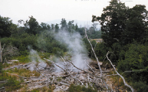
Cracks along state
Route 61 forced a permanent
detour around
the town. At top: A fresh vent
releases smoke
from the ground.
Images courtesy
of James Fogg. |
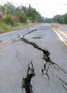
In 1982, borehole temperatures of 260 degrees Celsius beneath the borough
indicated the fire had ignited the anthracite directly below Centralia.
Fire also raged beneath state Route 61, the main four-lane highway on Centralias
southside. Temperatures beneath the road reached 455 degrees Celsius and
heat-induced cracks forced state environmental officials to stabilize the
highway in early 1983. Later that year, Congress appropriated $42 million
to relocate Centralia businesses and residences.
Between 1985 and 1991, Pennsylvania relocated approximately 1,000 occupants
of 545 residences and businesses, at a cost of $40 million. In 1992, the
state commenced condemnation procedures against 53 remaining properties.
Property owners filed objections to these procedures, but the courts denied
them. Ultimately, the U.S. Supreme Court ruled against their appeals in
1995. A year later, Pennsylvania notified Centralias 32 remaining property
owners that fire-related health and safety hazards demanded their relocation.
The commonwealth has yet to evict Centralias roughly 40 remaining residents.
Today, toxic gases and subsidence are ongoing hazards, and fire-generated
heat has ignited anthracite seams above the burning vein. The streets are
eerily barren. Few buildings remain, but reminders of underground mine
fire are plain: burnt, bleached or scorched trees and smoldering stumps
punctuate the landscape, cracks criss-cross roads, acrid sulfuric smoke
billows from fissures in the earth, and the ground is hot to the touch.
Fire has propagated in the subsurface over a 180-hectare area, with the
potential for consuming as many as 1,215 hectares. The fire, which may
burn for 100 years, spreads erratically, with months of no spreading or
months in which it spreads as much as 215 meters.
Implications
Unlike natural disasters in which hazards and responses are typically
well known and experience is vast, technological disasters like Centralias
underground mine fire are fraught with uncertainty, ambiguity and ignorance.
Scientists and policy-makers can offer no certain solutions, and governmental
emergency management agencies are poorly prepared to handle the problems.
No formal policy exists for responding to technological disasters, although
relocation is being used more frequently. Policy can help to define elements
of recovery from technological disasters and can provide guidelines for
helping communities and individuals cope with such disasters. Such policy
might include: central management of recovery; consideration of individual
and community recovery, along with environmental recovery; and enabling
residents of affected communities to assist in recovery, especially in
lessening intracommunity conflict.
In Centralias aftermath, it is clear that underground mine fire prevention
throughout Pennsylvania is paramount. Aggressive and complete treatment
of nascent abandoned mine fires is critical. Citizens must exercise their
rights, especially to spur elected officials into tangible, meaningful
action. Media involvement to heighten awareness also plays a key role.
Pressure must be brought to bear as soon as possible. Imagine Centralia
in 2000 had such pressure been applied in 1962.
Link
to the sidebar on underground mine fires.
Memmi is a GIS and database specialist
with the Senate of Pennsylvania and principal of the geoscience-consulting
firm, Apex Technology. He earned his doctorate in geological sciences from
Ohio State University.
Other
Activity
A major earthquake
of 7.0 preliminary magnitude hit Russias Sakhalin Island on Aug. 5, wounding
at least eight people and damaging 1,300 homes. The quake originated 10
kilometers below the surface.
Mexicos Popocatepetl
volcano exploded twice on Aug. 4. Ash reached the southern outskirts
of Mexico City, 40 miles to the northwest. Officials reported that this
activity is the strongest occurrence of the last two years, during which
time Popocatepetl has erupted regularly.
The first hurricane
of the season, Alberto, formed over the Atlantic Ocean on Aug. 4, with
winds quickly intensifying to 86 miles per hour. As of Aug. 8, forecasters
did not expect the storm to grow stronger, and the storm posed no threat
because the closest land mass was the Leeward Islands, more than 1,400
miles away, says Stacy Stewart of the National Hurricane Center in Miami.
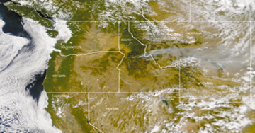
| More than 60
major blazes covered nearly 1 million acres in 11 Western states
on Aug. 7, said the National Fire Information Center in Idaho. The fires
in Idaho and Montana intensified. The numerous wildfires kept Colorados
Mesa Verde National Park closed. However, firefighters made headway against
California and Utah fires. It is the worst fire season in 50 years, officials
say.
At right: Smoke is visible
above Idaho, Montana and Wyoming.
Image courtesy of SeaWiFS
Project, NASA/Goddard Space Flight
Center and ORBIMAGE. |
 |
Spreading wildfires
forced the evacuation of thousands of people in northeastern Spain, near
the popular coastal resort of Rosa in early August. Authorities reported
that a total of 12,000 acres in the province of Catalonia were charred.
Flames also spread to the region of Llanca and the Cap de Creus Nature
Park. Although 19 airplanes helped fight the fire in the air, a strong
northern wind strengthened the flames. Catalan Interior Minister Xavier
Pomes said that a farmer burning off stubble in his fields could have ignited
the fire.
A strong eruption
on
July 27 opened a new crater on White Island, New Zealand. The crater is
about 120 meters by 150 meters in size, and discharged a reddish-brown
colored gas and ash plume.
|
| Earthlinks
http://neic.usgs.gov/neis/bulletin/bulletin.html
www.discovery.com/news/earthalert/earthalert.html
www.gns.cri.nz
|
Bridget Mulvey and Christina Reed compiled
Geophenomena.
