geotimesheader  
Geotimes Home Calendar Classifieds Subscribe Advertise

Geotimes
 Published by the American Geological Institute
Newsmagazine of the Earth Sciences

September 2000


News Notes

Sold!
 
It’s hard work managing a growing volcano, but somebody has to do it. Since the United States established the New Mexico Territory in 1850, private owners have kept the Valles Caldera, set west of Santa Fe in the Jemez Mountains of New Mexico, in relative seclusion. Now, geologists are thrilled over the prospect of gaining further access to what many consider the crown jewel of the state’s volcanic geology. “It’s really a world class volcanic landscape with spectacular geologic exposures,” says Richard Aster of the New Mexico Institute of Mining and Technology.

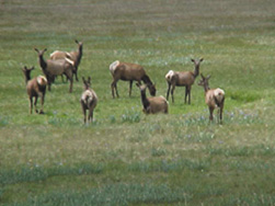
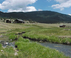
On July 25, President Clinton signed a bill giving final approval to the federal purchase of the family-owned Baca Ranch for $101 million. Approximately 88,900 acres of the ranch has the new title of Valles Caldera National Preserve, while Bandelier National Monument picked up 823 acres from the ranch’s southeast corner. The bill also allowed the Pueblo of Santa Clara to purchase 5,045 acres to protect the upper watershed of the Santa Clara Creek, the pueblo’s water supply for drinking, irrigation and cultural purposes.


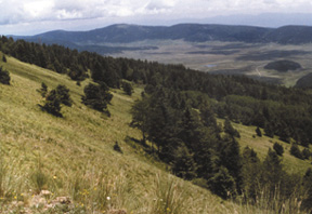
   In the Jemez Mountains of New Mexico in the Valles Caldera
   national Preserve will provide an outlet for visitors to explore
   the geology of the southwest. Images courtesy of USDA Santa
   Fe National Forest.

In 1821, Spain granted Don Luis Maria Cabeza de Vaca 500,000 acres near present-day Las Vegas. Following the end of the Mexican War, the U.S. gave Cabeza de Vaca heirs five 100,000-acre parcels of public domain. After a series of private owners, the late Texas oil tycoon James P. Dunigan bought the Baca Ranch in 1962 for $2.1 million.
 

About 5,000 elk graze the preserve.
In 1999, Sen. Jeff Bingaman (D-N.M.) and Sen. Pete Domenici (R-N.M.) sponsored a bill for the federal purchase of the Valles Caldera. In the past 100 years, the government has been in negotiations with one owner or another four times, he says. This is the second time since the 1960s.

Some questioned the value of the land. During the House debate Rep. John Duncan Jr. (R-Tenn.) called the federal purchase price “a colossal rip-off of the taxpayers.” Duncan was in the minority when the House approved the bill 377-45 on July 12.   Other federal purchases costing over $100 million include Fire Island National Seashore and Gateway National Recreation Area in New York, Assateague Island National Seashore in Maryland, and Sleeping Bear Dunes and Picture Rocks National Lakeshores in Michigan, Bingaman says.

A nine-member board of trustees will govern the Valles Caldera Trust in managing the land, an unusual practice that will leave the Forest Service out of the decision making process. The president has until late October to appoint seven people to the board to join forest ranger Leonard Atencio of the Santa Fe National Forest and the future superintendent of Bandelier National Monument. Members selected will represent expertise in livestock, wildlife, forestry and financial management, nonprofit conservation organizations, state or local government, and the cultural and natural history of the region. “Hopefully there’s a spot there for a real earth scientist,” Aster says. “It will be very important to see some people who will respect the scientific interest of the community on that board.”
 
The Trust will have two years to establish management plans with a goal of becoming self-sustaining. In the meantime the Forest Service is looking at ways to allow limited access and is asking for $900,000 during the first year for mainly law enforcement and inventory activities, Bingaman says.

“If you look at a forest service map of New Mexico there’s this gigantic, white hole in the middle of the Santa Fe National Forest, which is really the most spectacular part of the Jemez Mountains, that will now become accessible to the public,” Aster says. “And presumably also a lot more accessible to our community for research and educational purposes.”


   Ranch employees use a small number of outlying 
   cabins on the property, such as this one on San
   Antonio Creek.

Christina Reed


Geotimes Home | AGI Home | Information Services | Geoscience Education | Public Policy | Programs | Publications | Careers

© 2024 American Geological Institute. All rights reserved. Any copying, redistribution or retransmission of any of the contents of this service without the express written consent of the American Geological Institute is expressly prohibited. For all electronic copyright requests, visit: http://www.copyright.com/ccc/do/showConfigurator?WT.mc_id=PubLink