 Left:
David Loopes son Kevin at the Navajo Sandstone at Coyote Buttes, Arizona.
This cross-section shows thrust faults in slumped strata that are under
and overlain by undisturbed, dry-avalanche cross strata.
Left:
David Loopes son Kevin at the Navajo Sandstone at Coyote Buttes, Arizona.
This cross-section shows thrust faults in slumped strata that are under
and overlain by undisturbed, dry-avalanche cross strata.

About 190 million years ago, the Navajo Sandstone was a near-equatorial desert of windblown sand dunes. Today, with its towering fiery-red spires and sheer white cliffs, the eroded sandstone defines the landscape of southwestern Utah and Arizona. Its sediments also reveal what the seasons were like in western Pangaea during the Jurassic, say scientists in the July 5 Nature.
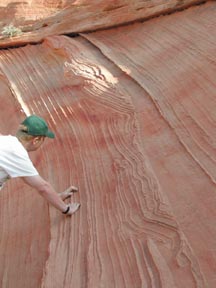
Left:
David Loopes son Kevin at the Navajo Sandstone at Coyote Buttes, Arizona.
This cross-section shows thrust faults in slumped strata that are under
and overlain by undisturbed, dry-avalanche cross strata.
Although the Jurassic is well known as the age of dinosaurs and the dawn of birds, details of its climate have remained something of a mystery. Fossil evidence suggests that while arid winds formed vast deserts in Pangaea, tropical conditions created dense forests of ferns and cycads. Geologists made sense of this data but were baffled by Pangaeas atmospheric circulation patterns. Now, a team of geologists from the University of Nebraska-Lincoln has found some answers in the layers of the Navajo Sandstone. They conclude that the Jurassic dunes of western Pangaea were deposited by strong, winter winds and drenched by summer monsoons.
By studying the Lower Jurassic portion of the Navajo Sandstone, David Loope, Clinton Rowe and R. Matthew Joeckel identified three significant indicators of Jurassic climate: wind-rippled wedges, pinstripes between avalanche strata and slumped masses of sediment.
Loope and his colleagues could see, in cross-section, that the large dunes migrated to the southeast, under the influence of dominant northwesterly winds. Most of the sandstones layers resulted from avalanches of dry, wind-blown sand. But, the authors explain, short-lived, northeasterly winds blew very fine sand up the steep slip face or lee side of the dunes, creating thin layers called pinstripes that are now evident in the outcrops. Wind from the northeast also blew sand across the slip faces of the dunes, creating a wind-rippled wedge at their base. The authors determined that these wedges were deposited in the spring and fall, the sand between them accumulated in one winter and the pinstripes show short-term wind reversals.
At 700 meters, the Lower Jurassic Navajo Sandstone in southwestern Utah is the thickest formation of the sandstone and the thickest wind-blown formation on the Colorado Plateau. Its deposition began in the Pennsylvanian Period and ceased at the breakup of Pangaea in the Late Jurassic. Loope and his colleagues analyzed outcrops in Utah and northern Arizona, focusing specifically on 24 sections with rain-induced slumping. Here they found folded, truncated sediment intervals, thrust faults and breccias between the smooth layers that characterize most of the formation. Many disrupted, slumped strata were concentrated near the wind-rippled wedges. From this, Loope and his co-authors reason that slumping resulted from individual storms during the summer monsoon season.
How did the authors determine that rainwater caused the slumping? By inference, Loope says. He compared the ancient environment of the Lower Jurassic Navajo Sandstone to the modern Sahara desert. Because West African monsoons bring heavy rain to the southern edge of the Sahara during July and August, Loope inferred that similar precipitation events occurred in the Navajo desert in western Pangaea.
As rainwater moistens the dunes, capillary forces stabilize its sand grains, Loope explains. But, when the sediment becomes quickly saturated, as during a monsoonal downpour, water fills all pore spaces, causing wet sand to slump down the dunes slip face.
The Sahara yields useful insight into the workings of Jurassic dunes, but does not experience the severity of monsoons or wind reversals that probably occurred in the Navajo Sandstone desert. Wed like to have a modern analogue, Loope says.
Nick Lancaster of the Desert Research Institute in Reno, Nev., researches grain deposition on dune slip faces. He, like Loope, hopes to find a modern desert where the processes of dune formation can be seen in action. One possibility is the Liwa area of the United Arab Emirates, Lancaster says. But promising study sites are uncommon because many large, modern dunes are the product of glacial-age wind regimes and do not reflect the climate patterns of the ice-free Jurassic.
Another enigma Loope would like to unravel concerns the weather patterns in the southern hemisphere of Pangaea. Co-author Clint Rowe plans to find out by incorporating the wind and precipitation data from the Navajo into a supercontinent-scale climate model of the supercontinent that could explore the links between subequatorial heating and anticyclone migration.
Such information could vastly improve the understanding of Pangaea and how its seasonality and wind patterns created both its lush and desolate environments.
Jann Vendetti
 |
Geotimes Home | AGI Home | Information Services | Geoscience Education | Public Policy | Programs | Publications | Careers |