
Fires dot Russia's Yakutsk
region
Etna's activity
Aftermath
of Allison
Earthquake
bulletin
Fires
dot Russia's Yakutsk region
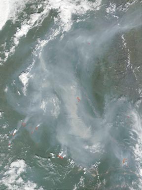
| A month after floodwaters from the Lena River ravaged towns and villages along the powerful waterway killing at least six people and destroying 10,000 homes or apartments the Yakutsk region in Russia is experiencing more hazards as fires dot the landscape. NASAs Terra satellite observed these fires in Russia using the Moderate-resolution Imaging Spectroradiometer. The red boxes show the locations of the forest fires. The greyish pixels are the thick smoke plumes produced by the flames. The green hues are the various tree and plant species comprising the thick canopy of the boreal forest. |
|
Etna's
activity
At 37.73 degrees North and 15 degrees East, the summit of Mount Etna
in Sicily, Italy rises 3,315 meters. On July 17 a large south flank eruption
from four new fissures produced several lava flows at elevations of 2,950,
2,700, 2,500 and 2,100 meters. A strong explosion erupted from a fifth
fissure on the northeast flank. During July 24-26, eruptive activity declined
at the 2,100-meter fissure, but then intensified on July 27 to reach the
original level of Strombolian activity on the evening of July 28. On July
26, modest lava emission occurred at the northeast fissure. At south flanks
2,500-meter fissure, where the strongest explosive activity occurred, a
change was noted from the mostly phreatomagmatic eruptions that were prominent
during the previous week to more violent Strombolian explosions and lava
effusion. After lava began to flow from the 2,500-meter fissure on July
25, a pyroclastic cone began to grow around three of the vents and by July
30 the cone was about 100 meters high. At the 2,950-meter fissure (near
the base of Southeast Crater) and 2,700-meter fissure lava emission and
mild explosive activity continued.

Above: The July 24 plume from the ongoing eruption of Mount Etna SHows a greenish-orange color in this 670/555/412 nanometer composite
On July 26, lava from the 2,500-meter elevation fissure flowed toward Rifugio Sapienza tourist complex, and as of July 31 lava surpassed constructed earth barriers and destroyed a cable car base station and a small tourist shop. Lava continued to flow from the lower vents of the 2,100-meter fissure in the direction of the town of Nicolosi (about 15 kilometers south-southeast of the volcano), but it was no longer considered a significant threat to the town. Near-continuous ashfall occurred south of the volcano, including in the town of Catania, about 25 kilometers south-southeast of the volcano. The international Fontanarossa airport in Catania was closed on July 29 and 30 due to ash on the runways. The Toulouse Volcano Ash Advisory Center reported that ash clouds were occasionally visible on the Sistema Poseidon Web cam and satellite imagery, with the highest cloud rising about 5.5 kilometers above the volcano.
Mount Etna, towering above Catania, Sicilys second largest city, has one of the worlds longest documented records of historical volcanism, dating back to 1500 B.C. Historical lava flows cover much of the surface of this massive basaltic stratovolcano, the highest and most voluminous in Italy. Two styles of eruptive activity typically occur at Etna. Persistent explosive eruptions, sometimes with minor lava emissions, take place from one or more of the three prominent summit craters: Central Crater, Northeast Crater and Southeast Crater. Flank eruptions, typically with higher effusion rates, occur less frequently and originate from fissures that open progressively downward from near the summit. A period of more intense intermittent explosive eruptions from Etnas summit craters began in 1995.
From the Global Volcanism Program/U.S. Geological Survey Weekly Volcanic Activity Report
Aftermath
of Allison
As damage is assessed and recovery costs are compiled, tropical storm
Allison's total damage estimates have climbed to $5 billion. On June 5,
tropical storm Allison developed in the Gulf of Mexico. It was the first
of the 2001 Atlantic hurricane season, and within a few days caused extensive
flooding and wind damage to Houston and nearby Galveston, Texas. Allison's
severity lessened to a tropical depression on June 6, but wind and rains
persisted, leaving Galveston under 3 feet of water. Flood damages at The
Texas Medical Center in Houston are estimated at $2 billion in lost laboratory
animals and tissue samples and in structural damage. The Center was
intentionally built in a 100-year floodplain, but poor rainwater drainage
due to urbanization has put the hospital at greater risk for flooding.
JV
Earthquake
bulletin
A magnitude-6.4
earthquake hit 55 miles northeast of Hachinohe, Japan, between the Honshu
and Hokkaido islands, on Aug. 13. The U.S. Geological Survey has documented
hundreds of quakes in this area since 1977. Eight of these quakes registered
at 7 or greater in magnitude.
JV
 |
Geotimes Home | AGI Home | Information Services | Geoscience Education | Public Policy | Programs | Publications | Careers |