Geotimes

Web Extra
Friday, September 13
El Niño
to shape fall and winter weather
 Eight
months ago, forecasters at the Climate Prediction Center, a branch of the National
Oceanic and Atmospheric Administration (NOAA), predicted El Niño would
develop in the tropical Pacific during the spring or summer - and they were
right. Yesterday NOAA climate experts predicted El Niño conditions will
continue through the fall and winter and will strongly influence temperature
and precipitation patterns throughout the country.
Eight
months ago, forecasters at the Climate Prediction Center, a branch of the National
Oceanic and Atmospheric Administration (NOAA), predicted El Niño would
develop in the tropical Pacific during the spring or summer - and they were
right. Yesterday NOAA climate experts predicted El Niño conditions will
continue through the fall and winter and will strongly influence temperature
and precipitation patterns throughout the country.
"El Niño is the dominant factor affecting fall and winter weather,"
says Jim Laver, director of NOAA's Climate Prediction Center. The El Niño
this year is mild compared to the 1997-98 event, and impacts on weather should
be more subtle.
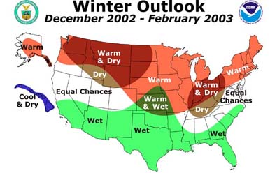
NOAA's winter weather outlook. Courtesy
of NOAA.
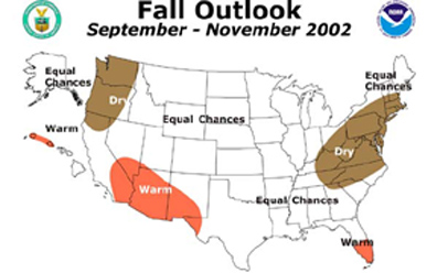
Predictions for the fall are patchy and do not offer much solace at a time
when more than half the country is experiencing droughts. "We don't see
much relief," says Jack Kelly, director of NOAA's National Weather Service.
Drier than normal conditions are expected in the Pacific Northwest and the Mid-Atlantic
States.
Southern Florida, the Southwest, and the western islands of Hawaii are expected
to be warmer than normal. But for the rest of country, patterns of precipitation
and temperature are up for grabs.
 The height
of El Niño's impacts should be in the winter, which is part of the reason
firm predictions cover more of the country in the winter than in the fall. The
winter is predicted to follow a "classic El Niño pattern,"
Laver says.
The height
of El Niño's impacts should be in the winter, which is part of the reason
firm predictions cover more of the country in the winter than in the fall. The
winter is predicted to follow a "classic El Niño pattern,"
Laver says.
That means more precipitation than normal throughout the southern part of the
country, from southern California to the Carolinas. In contrast, Washington
State, Northeast Oregon, Idaho, Montana, Wyoming, western parts of North Dakota,
and northwest South Dakota are all expected to be drier. All of the northern
states are predicted to be warmer than average.
In the Northwest, much of the yearly precipitation falls during the winter,
often as snow. The drier winter may therefore aggravate drought conditions from
the summer. "The message for the Northwest is: the picture is not so rosy,"
Kelly says.
NOAA's fall weather outlook. Courtesy
of NOAA.
Along the east coast, El Niño is expected to double the frequency of
storms, either rain or snow. This may accelerate beach erosion due to greater
wave activity.
This year's El Niño prediction came earlier than the prediction for
the 97-98 event, and points to an increasing understanding of how El Niño
works. Success rests, in part, on a system of buoys established in the tropical
Pacific for the sole purpose of monitoring sea-surface temperatures. According
to NOAA's definition, El Niño occurs when the sea surface in a section
of the tropical Pacific (defined by 120 degrees west longitude to170 degrees
west longitude and 5 degrees south latitude to 5 degrees north latitude) is
0.5 degrees Celsius, or more, warmer than the average (using 1971-2000 as the
base period) for at least three months. The warmer seas set off a chain of events
that affects weather throughout the world.
But as the patchiness of the fall predictions suggests, there is still a lot
of room for improving the monthly forecasts.
Greg Peterson
Links:
National Weather Service - Climate
Prediction Center (CPC)
El
Niño/La Niña homepage within the CPC
Wait and See for El Niño, May
2002
