
 In
the Timbuktu region south of the Sahara in Mali, patches of ground have been
smoking for many decades. Plumes of water vapor and carbon dioxide escape from
red-hot holes and fissures in the ground. In April 2001, the inferno below the
surface began to radiate outwards, scorching tree roots and leaving a trail
of burnt soils and fallen trees. Over the following 10 months, the subsurface
fires consumed more than 500 acres of richly vegetated land.
In
the Timbuktu region south of the Sahara in Mali, patches of ground have been
smoking for many decades. Plumes of water vapor and carbon dioxide escape from
red-hot holes and fissures in the ground. In April 2001, the inferno below the
surface began to radiate outwards, scorching tree roots and leaving a trail
of burnt soils and fallen trees. Over the following 10 months, the subsurface
fires consumed more than 500 acres of richly vegetated land.
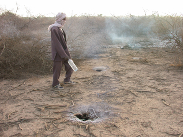
A local citizen watches smoke blowing out of fumaroles near Lac Faguibine, west
of Timbuktu, Mali. A team of Norwegian geologists found that subsurface peat
fires, not magma intrusions, fuel the fumaroles. Photo by Henrik Svensen, Volcanic
Basin Petroleum Research.
Theodore Monod, a French humanist and scholar, first characterized the smoking
holes, or fumaroles, in 1961. He concluded they were signs that the region had
become volcanically active. Magma bubbling up from depth fueled the fumaroles.
Local officials feared the recent increase in activity foretold a disastrous
volcanic eruption. The Ministry of Mines, Energy and Water in Mali asked a group
of Norwegian geologists who specialize in volcanic basins to visit the sites
and assess the hazard. According to their report in the August Geology,
in just four days, the geologists collected the data they needed to overturn
— and substantially reduce — the calculated risk for the region. The
authors found that the spontaneous combustion of buried peat layers, not migrating
magma, caused the subsurface fires.
In his original survey of the Lac Faguibine region, about 50 miles west of Timbuktu,
Monod found dikes mixed in with the soils around the fumaroles. He suggested
the dikes were basaltic and hosted the mineral nepheline, which could only have
come from magma. In the early 1990s, French geologists built a geologic model
of the region that supported the volcanism hypothesis by indicating that a huge
and dense mass, likely magma, sat just 2 kilometers beneath the surface. They
argued that a major east-west trending lineament had recently reactivated, and
that the energy from the pull-apart tectonics drove the magma intrusion. Later,
in 2000, a group of geologists from Sonatrach, an Algerian oil company, surveyed
the region and past research; they concluded that the fumaroles did indeed result
from volcanism — fueling local concerns of imminent disaster.
 When the Norwegian
team arrived in Mali, they expected to find signs of volcanism. Digging a 2.5-meter-deep
trench at Haribibi, one of the sites with fissures and escaping smoke, they
found a thin layer of peat burning just 60 centimeters below the surface. The
temperature in the peat layer exceeded 800 degrees Celsius, but dropped back
down to cool background levels just 70 centimeters farther down. “Then
we had two possibilities,” says lead author of the Geology paper
Henrik Svensen, a geologist at the University of Oslo in Norway. “The burning
peat layer was the only source of the heat anomalies, or the peat layer could
have been ignited by, let’s say, magma at 1,000 degrees Celsius. In the
latter case, magma would have to be present 1 to 1.5 meters below the surface.”
But they found no signs of magma.
When the Norwegian
team arrived in Mali, they expected to find signs of volcanism. Digging a 2.5-meter-deep
trench at Haribibi, one of the sites with fissures and escaping smoke, they
found a thin layer of peat burning just 60 centimeters below the surface. The
temperature in the peat layer exceeded 800 degrees Celsius, but dropped back
down to cool background levels just 70 centimeters farther down. “Then
we had two possibilities,” says lead author of the Geology paper
Henrik Svensen, a geologist at the University of Oslo in Norway. “The burning
peat layer was the only source of the heat anomalies, or the peat layer could
have been ignited by, let’s say, magma at 1,000 degrees Celsius. In the
latter case, magma would have to be present 1 to 1.5 meters below the surface.”
But they found no signs of magma.
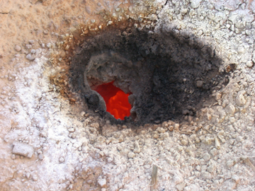
A close-up of one of the fumaroles shows
the fire beneath. White mineral sublimates have precipitated out of escaping
gases, accumulating around the edges of the hole. Photo by Henrik Svensen, Volcanic
Basin Petroleum Research.
The group concluded that microbial decomposition of organic matter in the peat
had likely generated enough heat to set the peat on fire. The impacted sites
sit in a dried-out lake basin; the old sediments provide the rich organic material
needed to stimulate high rates of microbial decomposition. “Burning peat
is a relatively common phenomenon,” Svensen says. Subsurface peat fires
burn in parts of Botswana, and surface peat fires occur frequently in the United
States and South Africa, he adds.
During the rainy season, the Niger River occasionally rises enough to flood
the Lac Faguibine region. Those floods have historically quelled the subsurface
heat, which matches the pattern expected from peat fires, not magma intrusions,
Svensen says.
The volcanism hypothesis persisted for over 40 years largely because Monod was
a legendary figure and a well-respected scientist, Svensen says. The minerals
that Monod initially argued formed from magma intrusion could just have easily
formed from the heating and melting of minerals in the burning peat, he adds.
Glenn B. Stracher, a geologist at East Georgia College in Swainsboro, Ga., who
studies subsurface coal fires, agrees. “Although lavas derived from coal
fires are documented in the geologic literature, people don’t usually consider
peat or coal combustion as the heat source for generating molten and subsequently
igneous rock,” Stracher says.
The several thousand people living in villages and nomad camps in the Lac Faguibine
region no longer face the prospect of a volcanic eruption, says co-author Dag
Dysthe, a physicist at the University of Oslo. But the peat fires still pose
potential health and environmental risks. By burning tree and grass roots, the
fires increase the rate of desertification at the fringes of the Sahara, Dysthe
says. Also, Svensen adds, the fires are extremely difficult to put out, and
the gases emanating from the fumaroles and fissures may contain hydrochloric
acid and sulfur dioxide, both toxic.
Greg Peterson
Back to top
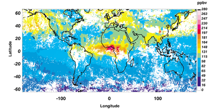 With no apparent
source for ozone formation in the southern hemisphere, “people in the atmospheric
research community were scratching their heads, trying to work out where the ozone
was coming from,” says David Edwards of the National Center for Atmospheric
Research in Boulder, Colo. “How do these pollutants move from the northern
hemisphere to the southern hemisphere?” This was especially perplexing given
that the pollutants would have traveled across the intertropical convergence zone,
a well-known atmospheric barrier to movement of air masses between hemispheres
in the tropics.
With no apparent
source for ozone formation in the southern hemisphere, “people in the atmospheric
research community were scratching their heads, trying to work out where the ozone
was coming from,” says David Edwards of the National Center for Atmospheric
Research in Boulder, Colo. “How do these pollutants move from the northern
hemisphere to the southern hemisphere?” This was especially perplexing given
that the pollutants would have traveled across the intertropical convergence zone,
a well-known atmospheric barrier to movement of air masses between hemispheres
in the tropics.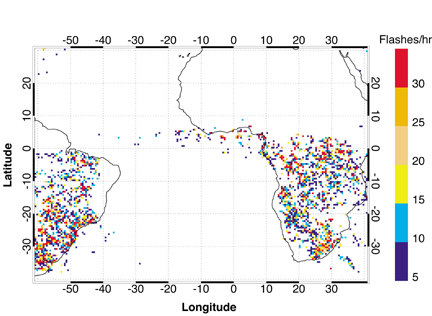 For the study reported
in the April 17, 2003, issue of Journal of Geophysical Research, Edwards
and his colleagues analyzed data from January 2001, a month when farmers in the
northern hemisphere of Africa traditionally set their ground-clearing fires. Carbon
monoxide was present in high concentrations in regions above the fires, but it
did not flow south of the equator — blocked by the intertropical convergence
zone, as expected. In the southern hemisphere, very few fires were present, but
the number of lightning strikes was substantial. Correlating lightning strikes
with nitrogen dioxide concentrations indicated clearly that lightning was the
cause of the high levels of ozone in the southern hemisphere of Africa at this
time of year.
For the study reported
in the April 17, 2003, issue of Journal of Geophysical Research, Edwards
and his colleagues analyzed data from January 2001, a month when farmers in the
northern hemisphere of Africa traditionally set their ground-clearing fires. Carbon
monoxide was present in high concentrations in regions above the fires, but it
did not flow south of the equator — blocked by the intertropical convergence
zone, as expected. In the southern hemisphere, very few fires were present, but
the number of lightning strikes was substantial. Correlating lightning strikes
with nitrogen dioxide concentrations indicated clearly that lightning was the
cause of the high levels of ozone in the southern hemisphere of Africa at this
time of year.  |
Geotimes Home | AGI Home | Information Services | Geoscience Education | Public Policy | Programs | Publications | Careers |