
 As coastal residents are geared up
for this year’s peak Atlantic hurricane season — mid-August through
October — scientists are looking at past hurricanes to better understand
what happens to the oceans in the wake of these whirlwind events. They are finding
that the storms actually help to fertilize the waters left in their wake, potentially
affecting the global carbon cycle and climate change.
As coastal residents are geared up
for this year’s peak Atlantic hurricane season — mid-August through
October — scientists are looking at past hurricanes to better understand
what happens to the oceans in the wake of these whirlwind events. They are finding
that the storms actually help to fertilize the waters left in their wake, potentially
affecting the global carbon cycle and climate change.
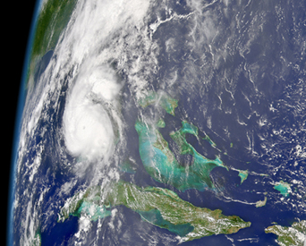
Satellite images like this one, taken of Hurricane Charley on Aug. 13, show
subtle changes in ocean color in the wake of hurricanes due to phytoplankton
blooms. Hurricanes stir up nutrients from the bottom of the ocean. Image courtesy
of NASA/Orbimage.
The intense winds from hurricanes blowing across the sea surface stir up deep,
nutrient-rich water, allowing phytoplankton populations to surge, according
to a recent study. Normally, parts of the ocean are like a desert for these
microscopic plants, says Steven Babin, an atmospheric scientist at the Johns
Hopkins University Applied Physics Laboratory in Maryland and lead author of
the study, which appeared in the Journal of Geophysical Research — Oceans
last spring. “Some phytoplankton are always there; there is just little
to make them grow” without nutrients from hurricanes, Babin says.
Satellites are giving researchers a whole new view of phytoplankton. Chlorophyll,
the green pigment in plants, is an indicator of phytoplankton and can subtly
affect the color of the ocean, which satellites are able to measure. Previously,
scientists had only been able to take point-samples of chlorophyll from ships.
“The investment made years ago is now finally paying off with the satellites,”
says Marlon Lewis, a biological oceanographer at Dalhousie University in Nova
Scotia. “It is a little difficult to take those measurements by boat in
a hurricane.”
Babin’s team used satellite data collected as part of NASA’s Earth
Science Enterprise to measure chlorophyll. In examining 13 hurricanes from 1998
to 2001, they found that high levels of chlorophyll immediately followed hurricane
events. The researchers considered that the high chlorophyll levels might only
be disassociated chlorophyll, stirred up by the hurricane, but the blooms lasted
for too long. “If it was just chlorophyll, it should disperse rather quickly,
like throwing flour into the air, but the effects lasted for weeks,” Babin
says.
The exact duration of a phytoplankton bloom appears to be linked to the size
of the hurricane. “With slow-moving, very large, very intense hurricanes,
larger blooms are more likely to occur. If the hurricane is too small, it is
possible that blooms may not form at all,” says Tommy Dickey, an oceanographer
at the University of California, Santa Barbara, Ocean Physics Laboratory and
co-author of the paper.
Phytoplankton blooms related to hurricanes may have important implications in
the carbon cycle. Phytoplankton, like all plants, absorb carbon dioxide from
the atmosphere and “act as a sink for carbon as the planktonic materials
sink to the ocean bottom,” Dickey says. Determining the exact sources and
sinks of carbon dioxide is vital to understanding possible climate change. Large
blooms of phytoplankton following hurricanes may lead to the removal of excess
carbon dioxide out of the atmosphere, potentially slowing global warming. But
“there are other factors at work too,” Babin says. “It would
be nice if we had a net loss of carbon in the atmosphere, but we have not looked
at the numbers yet.”
If scientists can prove hurricane-induced phytoplankton blooms reduce carbon
dioxide levels, it would help explain discrepancies in the amount of carbon
entering the oceans, Lewis says. “We don’t have all the sources for
total carbon absorption by the sea figured out. We are missing something out
there — it might be the hurricanes … or some other ephemeral event,”
he explains.
In the meantime, the National Oceanic and Atmospheric Administration has predicted
an unusually active hurricane season for this year, which lasts until Nov. 30.
During that time, six to eight hurricanes are expected to materialize with up
to four of those reaching Category-3 status. Already, Hurricane Charley made
landfall in Florida in mid-August as a Category-4 storm.
Jay Chapman
Geotimes intern
For a scorecard of the success of past NOAA hurricane predictions, go to TKTKTKTKTKTKTK.
Back to top
 |
Geotimes Home | AGI Home | Information Services | Geoscience Education | Public Policy | Programs | Publications | Careers |