
 Two major
earthquakes struck the fault that lies beneath Tokyo in recent history, a magnitude-8
in 1703 and a magnitude-7.9 in 1923 that had massive fatalities. Many smaller
events have happened since, including a magnitude-6.1 earthquake on July 23.
The fault lies beneath the city of more than 33 million people, and seismologists
now think it sits closer to Earth’s surface than previously thought. If
the fault is indeed shallower, the new assessment has the potential to revise
the projected hazards Tokyo may face in the future.
Two major
earthquakes struck the fault that lies beneath Tokyo in recent history, a magnitude-8
in 1703 and a magnitude-7.9 in 1923 that had massive fatalities. Many smaller
events have happened since, including a magnitude-6.1 earthquake on July 23.
The fault lies beneath the city of more than 33 million people, and seismologists
now think it sits closer to Earth’s surface than previously thought. If
the fault is indeed shallower, the new assessment has the potential to revise
the projected hazards Tokyo may face in the future.
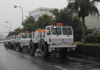
Geophysicists reevaluated the depth of
a major fault beneath Tokyo, using trucks to send vibrations into the ground
that are reflected as they pass through layers of rock below. Courtesy of Hiroshi
Sato.
The Pacific, Eurasian and Philippine Sea plates all come together
underneath the Japanese island of Honshu, marking the western edge of the Ring
of Fire. “The plate geometry beneath Tokyo is very complicated,” says
Hiroshi Sato of the Earthquake Research Institute at the University of Tokyo,
who is lead author of the report published in Science on July 15.
To better examine the plates’ positions, Sato and his co-workers used four
vibration-generating trucks, air-guns and stationary explosives, to create deep
seismic reflection profiles throughout Tokyo. They say the new profiles show
that the upper surface of the Philippine Sea Plate, where earthquakes would
potentially start, is at depths of 4 to 26 kilometers, as opposed to dipping
more steeply to 50 kilometers depth as previously thought. Although the new
fault profile does not change the shaking known to have occurred in the 1923
event, it will better refine models projecting potential future shaking and
damage to the city of Tokyo.
Sato likens his team’s project to tactical defense in warfare: “We
have to know or estimate [an] enemy’s attacks. Our strategy is to estimate
strong ground motions,” he says, which are affected by the position of
the source fault and the geologic setting, in addition to building construction
and geographic siting. The reevaluation comes at a time when the Japanese government
has launched a special project for earthquake disaster mitigation in urban areas,
spending $10 million over five years to do so.
Seismic profiling of the Philippine Sea Plate descending beneath greater Tokyo
is the program’s “flagship effort,” says Ross Stein, a geophysicist
at the U.S. Geological Survey in Menlo Park, Calif. “I think they are correct
that the plate is shallower and less steeply inclined than inferred” by
previous research using the distribution of microearthquakes, Stein says.
Still, the vibrations and sound waves pass through “reflector” layers
that can give off very weak and discontinuous signals, Stein says, as the waves
cross what might be transitions between different rock types or plates. Such
variability makes surface seismic profiles subject to interpretation, he says.
Naomi Lubick
 |
Geotimes Home | AGI Home | Information Services | Geoscience Education | Public Policy | Programs | Publications | Careers |