
|
 Subscribe

NEWS NOTES
Geophenomena
Fires rage across the West
|
| This image, taken on July 31 by the Moderate Resolution Imaging Spectrometer (MODIS) on NASA’s Aqua satellite, highlights six of Montana’s largest fires. Actively burning fires are outlined in red. |
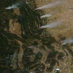
When the 2007 fire season officially began on Aug. 1, dozens of wildfires were already burning across the West thanks largely to high temperatures and a moderate to severe drought across the Rockies this summer. Montana has been hardest hit so far, with 15 large fires burning out of control on Aug. 6. About 104,600 acres have already burned in Montana, according to the National Interagency Fire Center (NIFC). The Pacific Northwest and northern Rockies are taking the brunt of the fires, but across the West, 43 large fires were burning as of Aug. 6, accounting for almost 650,000 acres on fire. The fires closed roads in several states and forced evacuations in some communities.

