aprilheader.html

Web Feature
Link to side bar: Geoscientists on America's
Public Lands
 |
Geology
in the National Park Service
by David B. Shaver and Jim
F. Wood
"Of all the questions which can come before
this nation, short of the actual preservation if its existence in a great
war, there is none which compares in importance with the great central
task of leaving this land an even beter land for our descendants than it
is for us, and training them into a better race to inhabit the land and
pass it on."
President Theodore Roosevelt
|
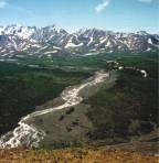
[Image above: Stream channel
morphology and sediment load in this stream at Denali National Park are
indicators that can reflect changes in basin conditions, including climate,
soils, erosion rates, vegetation, topography and land use. Photo courtesy
of the National Park Service.]
As geologists know, the national parks of
the United States contain spectacular examples of the landforms and geologic
features that make up our planet: the Grand Canyon and other features known
around the world; dynamic geologic processes such as shorelines; vulnerable
resources like cave systems; and highly prized specimens such as fossils
and mineral. Of the more than 380 parks, at least 160 encompass significant
geologic resources, more than 140 contain noteworthy fossils, 66 boast
dynamic shoreline geology, more than 75 include cave and karst systems,
49 have volcanic features and 24 sit atop active geothermal zones.
However, the public and most park managers have largely viewed these
physical features as scenic backdrops to the plants and animals that exist
within them. Historically, most National Park Service staffing was focused
first on visitor services and then on biological resources. Despite the
extensive geologic resources in parks, geology has often been inadequately
accounted for in park planning, facility design and placement, visitor
safety, resource management and visitor education. The consequence has
sometimes been park facilities built in flood- and erosion-prone areas,
park visitors exposed to geologic hazards, educational displays that are
incomplete, geologic specimens stolen or vandalized, or natural resource
management without physical science information.
Increased attention to ecosystem management and awareness of natural
systems interactions is changing this mindset. The Park Service is recognizing
the need for more scientific information in park management including
input from the geosciences.
Managing parks
with geology
 Despite
the importance of the physical environment to ecosystems, the geosciences
traditionally have not been well integrated into land management or ecosystem
planning. Planning teams often overlook geologys role as a major determinant
of topography, water and soil chemistry, soil fertility, stability of hillsides,
and the flow styles of groundwater and surface water. This oversight has
occurred, in part, because traditional approaches to land management treated
the landscape either as a static scene or as a web of biologic processes
playing out on an inert geologic stage. But the landscape is a collection
of dynamic processes biologic, geologic and social that are interrelated
and interdependent. One of the educational goals for geoscientists working
with park staffs should be to help define the role of geology in the ecosystem.
Despite
the importance of the physical environment to ecosystems, the geosciences
traditionally have not been well integrated into land management or ecosystem
planning. Planning teams often overlook geologys role as a major determinant
of topography, water and soil chemistry, soil fertility, stability of hillsides,
and the flow styles of groundwater and surface water. This oversight has
occurred, in part, because traditional approaches to land management treated
the landscape either as a static scene or as a web of biologic processes
playing out on an inert geologic stage. But the landscape is a collection
of dynamic processes biologic, geologic and social that are interrelated
and interdependent. One of the educational goals for geoscientists working
with park staffs should be to help define the role of geology in the ecosystem.
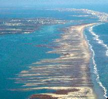
[Above right: A hurrican
created this inlet, now artificially maintained, at the north end of Assateague
Island National Seashore in Maryland and Virginia. The inlet caused changes
in shoreline position that are leading to accelerated erosion and overwash,
thus causing unnatural loss of this barrier island and the protection it
gives the mainland. Photo courtesy of the National Park Service.]
The National Park Service was established in 1916 with a congressional
mandate to preserve park resources for future generations, and to simultaneously
provide compatible opportunities for public enjoyment. This mandate applies
to the more than 380 units of the National Park System and ensures the
parks value to visitors as well as their value as repositories of natural
systems and our cultural heritage. Recent decades have brought not only
a growing number of visitors to parks, but also encroaching pressures
from external development. Both factors have created the need for active
management by the Park Service to preserve, maintain and restore natural
systems in the parks. In 1997, Richard Sellars book Preserving Nature
in the National Parks, along with earlier reviews by the Park Service and
external organizations, showed that much of this management was being done
with ambivalence about the role of science in park management and decision
making. The Park Service now recognizes that active management requires
scientific knowledge and understanding of natural systems.
A challenge for park resource managers is seeing that the relevance
of geology to their parks includes not only the relatively long geologic
time scales but also the shorter time scales in which changes can occur
in a human lifetime. As a land manager, the Park Service is interested
in environmental assessments, particularly those that can identify rapidly
changing conditions. Most park resource managers are familiar with the
indicators and monitoring methods to detect change in the biological components
of the ecosystem.
Park managers are now beginning to measure geologic change using
geoindicators developed by the International Union of Geological Sciences
to improve ecological assessments. Geoindicators are a class of environmental
indicators developed to assist in ecosystem research, monitoring and reporting.
Examples include coral chemistry and growth patterns, dune formation, glacial
fluctuations, relative sea level, shoreline position, soil erosion, stream
channel morphology and wetlands extent.
Using geoindicators, park managers can identify geologic and hydrologic
features and processes that can be used to evaluate the state of the environment,
how ecosystems are changing and how humans are affecting natural systems.
The Park Services Geologic Resources Division and its partners are working
with parks to integrate geoindicators into the Park Vital Signs monitoring
program and to develop long-term monitoring that includes the geoindicators
concepts. The Park Vital Signs program consists of 32 multi-park networks
that will conduct long-term ecological monitoring of selected parameters,
or vital signs. The goal of this monitoring is to assess the basic health
or integrity of park ecosystems to facilitate appropriate management action.
Partnering with
geoscientists
 The
Park Service increasingly recognizes that successful resource management
requires good science and has undertaken actions to improve resource management
decision making. In 1999, the Park Service launched a five-year initiative,
the Natural Resource Challenge, to improve NPS professional expertise and
access to scientific information and research.
The
Park Service increasingly recognizes that successful resource management
requires good science and has undertaken actions to improve resource management
decision making. In 1999, the Park Service launched a five-year initiative,
the Natural Resource Challenge, to improve NPS professional expertise and
access to scientific information and research.
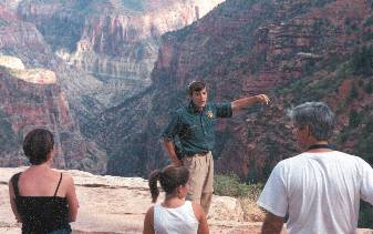
[At right: Clifton Koontz,
a summer 2000 GeoCorps particpant, describes geologic history to visitors
at Grand Canyon National Park. "Grand Canyon is a geologist's playground,"
Koontz says. "Nowhere else is arid-land erosion so dramatically displayed,
or a rock sequence so clearly exposed. These resources also make the Grand
Canyon an interpreter's ideal classroom." Photo courtesy of GSA.]
Even earlier, as part of a 1995 restructuring, the Park Service created
the Geologic Resources Division to provide park managers with geologic
expertise. A budget increase in 2000, resulting from the Natural Resource
Challenge, allowed the division to reach a basic complement of technical
specialists. The division now employs 25 professionals in geology and minerals
management specialists in caves, coastal processes, geomorphology, paleontology,
petroleum geology, mining and regulatory policy who provide expert assistance
to park managers across the National Park System. Almost as many geologists
are employed in parks and offices across the country. Although outnumbered
more than ten-to-one by Park Service biologists, these geoscientists are
becoming part of an integrated approach to science-based resource management
in parks.
Soon after it was established, the Geologic Resources Division began
working to improve its access to geologic expertise, training and information,
and to secure funding for geologic resource management. To build a network
between the parks and geologic community, the division:
-
established liaison offices in U.S. Geological Survey (USGS) regions
to draw upon the Surveys scientific capabilities;
-
built partnerships with geologic societies, universities and museums;
-
prepared geology training manuals for several parks to help resource
managers and park guides;
-
created an extensive geology Web site to improve public understanding
of park geologic resources and concerns; and
-
completed inventories of geologic resources for parks in Colorado,
Utah and North Carolina.
Also in 2000, the Park Service hired Zelda Chapman Bailey from the USGS
as an interim director to develop a partnership for establishing a National
Cave and Karst Research Institute. And in recent years, new geology staff
have been hired at Big Bend National Park, Dinosaur National Monument,
Guadalupe Mountains National Park, Yellowstone National Park and Whiskeytown
National Recreation Area. Other park and regional geology positions are
being developed. The service has established an informal geology network
to share valuable information and expertise.
Geoscience organizations and individuals are supporting the Geologist-in-the-Parks
program, which places geology students, professors, professionals and retired
geologists in park positions to accomplish resource management, education,
interpretation, research and safety projects. The program fills some permanent
and seasonal positions in parks, but its heart is in partnering with the
geologic community to sponsor volunteer and temporary positions for
geoscientists in parks, where their work helps to demonstrate the importance
of geology in everyday park operations.
Since 1996, when the program began, more than 200 individuals have participated.
Geologists have addressed many park needs such as glacial coring and data
collecting for global warming studies, compiling paleontological inventories,
documenting and monitoring caves, identifying geologic hazards, assessing
coastal geomorphology and updating displays and education programs. The
program would not be possible without the support of its partners, including
the Geological Society of America, the Association for Women Geoscientists,
the National Association of Black Geologists and Geophysicists, the Student
Conservation Association and the University of Denver.
The National Park Service will never be able to hire a sufficient number
of geoscientists to work in all the national parks, regions and various
network offices it manages. Thus, when park managers plan new developments,
identify management alternatives, prepare educational programs, design
restoration projects, or perform the tasks that require natural systems
information, the geosciences may not always be represented. The Geologic
Resources Division and its partners have been working to provide information
to park managers that can help them identify areas where geology should
be considered in park activities and can contribute information for making
management decisions. As park managers gain access to geoscientists, they
gain an appreciation of the value and relevance of geology for preserving
and understanding park resources.
Getting involved
With more than 270 million annual park visits, plus more than one million
Internet visits daily, the National Park Service can be an excellent partner
for the geologic community in communicating the relevance of geology and
earth systems to the public.
The Park Service welcomes geoscientists involvement in improving park
geology education and hopes to develop a broad-based coalition of public
and private-sector geology partners to improve geology education not only
for the public, but also for Park Service managers, naturalists and rangers.
The geologic community and its individual members can:
-
Involve the parks. Notify park staff of opportunities to participate in
local field trips; include parks in mailing lists for meetings and events;
send geology publication notices or copies to park libraries; provide copies
of geology field trip materials to parks; and use parks as examples in
their teaching.
-
Collaborate with parks. Work with park education specialists to create
new geology programs for local schools; help incorporate scientific information
into ranger talks and visitor guide products; present geology overviews
to park staff during their training; lead a geology field trip for park
staff; contribute geology topics to post on park Web pages; provide technical
reviews to update visitor education books and programs; present a special
visitor education program.
-
Be a citizen-geologist. Provide a geologists perspective to park planning;
be involved in social, political and economic decisions that affect parks;
support professional organizations that are involved in public policy;
become involved in your local parks; help to raise awareness of the role
of geology in natural systems.
Americas National Park System has been described as the worlds
greatest set of outdoor classrooms. But the educational value of those
classrooms will be lost if we fail to recognize they are simultaneously
the greatest set of natural laboratories. The study of the extensive and
diverse geologic features and processes in parks will give us an ever-expanding
source of knowledge and information.
The Park Service is actively working to make parks more accessible to
researchers. The information that geologists can gather is much more than
interesting facts and curious statistics. It is the substance that underlies
our understanding of Earths natural history and the context of the human
experience. Knowledge of past ecosystems and Earths processes will allow
us to make informed decisions, take science-based actions in the parks,
and inspire similar decisions and actions outside the parks.
National parks are preserved by and for U.S. citizens. The geologic
community has much to contribute to understanding, appreciating and preserving
the national parks. This contribution goes to the core of the National
Park Service mission to preserve the nations most precious resources.
Shaver is chief of the National Park Services
Geologic Resources Division. E-mail: dave_shaver@nps.gov
Wood is the education specialist for the
Geologic Resources Division. He coordinates Park Service geologic educational
goals with external partners and works with parks to develop educational
programs, general interest geology publications and Internet sites.
