
|
 Subscribe

Web Extra Monday, April 2, 2007
Earthquake and tsunami devastate Solomon Islands
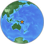 |
| A magnitude-8.0 earthquake struck the Solomon Islands on Monday morning. A several-meters-high tsunami followed, inundating several villages along the coast. Image is courtesy of USGS. |
A magnitude-8.0 earthquake struck the Solomon Islands Monday
morning, followed by more than a dozen strong aftershocks, several of which
topped magnitude 6.0, according to the U.S. Geological Survey
(USGS). A deadly tsunami followed the main quake within minutes, inundating
small towns along the coast.
The main shock struck 40 kilometers offshore of the southern Solomons at 7:39
a.m. local time on Monday, says David Applegate, USGS senior science advisor
for Earthquake & Geologic Hazards. The quake was also "very shallow,"
at just 10 kilometers deep, Applegate says, which meant there was very strong
shaking on the islands. Significant damage is likely, he says, but details are
unknown, largely because reports suggest that power and communications to the
regions most affected have not been restored yet.
The NOAA Pacific Tsunami Warning Center issued a tsunami
warning within 15 minutes of the quake, Applegate says, and predicted that small
tsunamis could hit Australia and Papua New Guinea. They also issued advisories
for Hawaii and other areas around the Pacific Rim. Indeed, "small tsunamis
less than a foot in height were reported in Australia and Papua New Guinea,"
he says. NOAA has since canceled the advisories.
The Solomons were not as fortunate, however, as the tsunami that hit the islands
"probably struck before our seismometers even picked up the seismic waves,"
Applegate says. Preliminary reports suggest a tsunami up to a couple of meters
high washed ashore in the towns along the southwestern coast of the South Pacific
island chain. People had only a couple of minutes to react and move to higher
ground. The quake and tsunami have left at least 13 people dead, and probably
many more, according to Associated Press reports. Residents
of the city of Gizo, the second-largest town in the Solomon Islands, told Associated
Press that much of the town was flattened by the temblor and ensuing waves.
"Tsunami warning [broadcasts] are a wonderful tool for reaching more distant
areas and warning people, but this type of event underscores the need for education
and preparedness on the ground," Applegate says. Residents and emergency
managers in local areas need to know that when the ground shakes violently,
as it did with this large quake, they need to take action and move to higher
ground the minute they can get their feet under themselves, he says. "It
comes down to education."
The Solomon Islands is an archipelago of more than 200 islands, located northeast
of Australia. It is part of the so-called Ring of Fire, a tectonically and volcanologically
active area that rims the Pacific Ocean.
Links:
Details
on the Solomons Quake at the U.S. Geological Survey Earthquake Hazards Program
NOAA
Pacific Tsunami Warning Center
Associated
Press news report

