
|
 Subscribe

NEWS NOTES — GEOPHENOMENA
Ancient caldera hints at Cascades’ power
Bubbling methane makes Arctic seafloor hilly
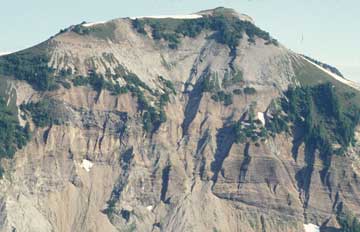 |
Washington’s Hannegan Peak, in the northern Cascades volcanic range, contains ash flow deposits, volcanic glass and cemented rock fragments, evidence of a massive eruption 3.7 million years ago. The eruption was powerful enough to form a caldera at the mountain’s summit — a rarity in the Cascades. Photograph is by David Tucker. |
When Mount St. Helens erupted in Washington in 1980, following more than 100 years of quiet, it was a pointed reminder that the 37-million-year-old Cascades range along the northwestern coast of the United States is far from dormant. That eruption was small compared to events in the volcanic region’s past, however, a team of researchers says. The team’s discovery of a massive crater, resulting from an ancient eruption in northern Washington, brings to six the number of powerful “supervolcano” eruptions known to have occurred in the Cascades throughout its history, and hints at the volcanic chain’s potential power, they suggest.
“Supervolcano” is not a geological term, but has become non-technical shorthand for the kind of massive volcanic eruption that leaves behind a giant bowl-shaped crater, or caldera, such as the one that now holds Oregon’s Crater Lake, says David Tucker, a volcanologist at Western Washington University. Caldera-forming eruptions are many times more powerful than Mount St. Helens’ most recent eruption, and worldwide, there have been few such events in human history, Tucker says. One was the 1883 eruption of Krakatoa in Indonesia, which ejected enough rock, ash and pumice into the stratosphere to cool the world for a year and destroyed most of the island on which it was located. Another was the 1912 eruption of Alaska’s Katmai (Novarupta) Volcano, the largest eruption in the 20th century, which produced a massive caldera at the volcano’s summit.
Volcanic arcs such as the Aleutians and the Andes are peppered with dozens of calderas from their millions of years of eruptive history — but the Cascades volcanoes appear to have produced few calderas since they began erupting 37 million years ago, according to a 1996 study by volcanologist Wes Hildreth of the U.S. Geological Survey in Menlo Park, Calif. Only three calderas are known to have formed in the Cascades during the Quaternary Period, which extends from 1.8 million years ago to the present: the 7,000-year-old Crater Lake, the 600,000-year-old Rockland Caldera at Mount Lassen in California, and a one million-year-old crater on the eastern flank of Mount Baker in Washington. “That’s it,” Tucker says.
Tucker and Hildreth think that there are more, possibly older calderas not yet identified in the region, however. One, a Tertiary-aged caldera at Hannegan Peak in northern Washington, was first mapped by Tucker in a 2004 paper, but because the crater is well-exposed, he says, the site offered a “great opportunity” to study a volcanic arc caldera close-up and in cross-section.
Returning to the site, Tucker, Hildreth and their team found that the eruption and subsequent collapse of the crater appeared to have occurred in two phases rather than one, they reported in the March/April issue of the Geological Society of America Bulletin. Calderas generally form when a plume of magma pushes its way into the crust, deforming its shape so that it bows upward. That deformation produces faults that allow gases to escape, and ultimately, the pressure builds and the large volume of magma waiting just below the surface erupts.
At Hannegan, Tucker says, the eruption began about 3.7 million years ago, and as it continued, the overlying crust began to fall into the emptying magma chamber. Instead of the whole roof of the chamber dropping down like a piston, however, only one side collapsed, swinging down like a trapdoor. Then, about 300,000 to 400,000 years later, the hinge switched to the opposite side, and the second half collapsed in another trapdoor swing, forming a more symmetrical caldera shape. Such a two-phase trapdoor event has been shown in laboratory studies using sandbox models to simulate eruptions, Tucker says, but has never before been observed in the field.
In addition to the unusual collapse mechanism, the caldera itself suggests that “there’s the potential for some really huge eruptions in the Cascades,” Tucker says. Such eruptions would not occur without plenty of warning from seismographs and other data, but the location of the caldera does suggest that a major eruption can occur where no volcano has previously existed — and could be very big. “If people think at all about Cascades volcanoes, they think, ‘Mount St. Helens — that was big,” he says. “It’s a drop in the bucket compared to these things.”
That is a valid conclusion, says Cynthia Gardner, a volcanologist at the Cascades Volcano Observatory. Although they are rare, she says, “clearly the Cascades are capable of producing caldera-forming eruptions.” And the fact that there was one fewer than 10,000 years ago, at Crater Lake, suggests that the likelihood of another such eruption occurring in the Cascades at some point “is probably pretty high,” she says.
Rising sea levels are flooding the once-frozen Arctic shelf with warmer waters and are possibly creating a new kind of underwater landscape. The warmer waters may be releasing methane once trapped under the cold permafrost of the seafloor, creating a series of small hills on the seafloor, according to a new study.
While searching for places in the Arctic shelf where methane gas hydrates might be venting, a team of researchers led by marine geologist Charles Paull of the Monterey Bay Aquarium Research Institute focused on what they dubbed “pingo-like features” on the seafloor. Pingos, named after the Inuit word for “small hills,” are mounds of earth-covered ice that are found in permafrost terrain. On the Arctic seafloor, however, such pingo-like features, observed in seismic surveys, might be locations where freed methane is bubbling to the surface, the team reported Jan. 5 in Geophysical Research Letters.
In permafrost regions, methane can be trapped in sediments as a gas hydrate, in which ice contains abundant methane in its crystal structure (see Geotimes, November 2004). Warm water progressively seeping downward through the sediment, however, could release the frozen gas.
To determine whether the hills were related to such freed methane, the team collected cores of seafloor sediment from eight pingo-like hills on the shelf, and measured their methane content. The team also collected seismic data and employed remotely operated vehicles to scan the seafloor around the hills.
The data revealed as much as six times more methane in the hills relative to the surrounding sediments, and decreasing sulfate concentrations. The seismic data, which showed the locations of the hills, also revealed that they are surrounded by “moats,” or rings of lower-lying sediment. And the remotely operated vehicles scanning the sites observed streams of bubbles emerging from the crests of the hills, the team reported.
Based on this information, the team proposed an unusual scenario for the formation of the pingo-like features: As the buried gas hydrates decompose into water ice and gas, they increase the pressure underground and force the surrounding sediment to expand upward toward the seafloor. The surrounding moats, the team suggests, are likely to form after the gas has vented and the once-expanded seafloor collapses around the hills, forming circular depressions. The Arctic’s hilly underwater landscape could be the product of escaping methane — and, therefore, one product of rising seas and warmer waters in the region.
Links:
"Methane Hydrate and Abrupt Climate Change," Geotimes, November 2004

