
 Water
is a key control on the health of plants. Recent studies have shown that careful
irrigation management can have beneficial effects on many crops, including almonds,
citrus, plums, pistachios and wine grapes. Such management is especially important
in water-scarce regions that have a large agricultural industry. California, for
example, is one of the nation’s most productive farm states, producing 50
percent of the nation’s fruits, nuts and vegetables on more than 8.8 million
acres of farmland. With 80 percent of the state’s developed water being used
through irrigation for agriculture, California uses more water than any other
state in the nation.
Water
is a key control on the health of plants. Recent studies have shown that careful
irrigation management can have beneficial effects on many crops, including almonds,
citrus, plums, pistachios and wine grapes. Such management is especially important
in water-scarce regions that have a large agricultural industry. California, for
example, is one of the nation’s most productive farm states, producing 50
percent of the nation’s fruits, nuts and vegetables on more than 8.8 million
acres of farmland. With 80 percent of the state’s developed water being used
through irrigation for agriculture, California uses more water than any other
state in the nation. Traditional approaches
Through trial and error and over hundreds of years, French winemakers have
recognized that certain areas within vineyards produce finer wines than others.
Wines made from the same kind of grapes that are grown in the same region, using
identical farming procedures, which are harvested at the same time and made
into wine in exactly the same way, can be dramatically different. Some wines
may be dryer or more astringent than others, and the color intensity and aromas
may vary. Soils play a significant role in such “terroir.”
Due to natural geological processes, soil properties can vary laterally over
distances as small as several meters. Recognition of these small-scale variations
within a vineyard or portion of a vineyard can lead to premium wines that reflect
the terroir of the area. The historical perspective that has helped define terroir
in traditional wine-grape- growing areas, however, is absent in newer winemaking
areas, such as California and Australia. Thus, New World farms still face the
challenge of mapping their soil properties in detail.
Wine grape growers generally accept that moderate water stress on grapevines
early in the growing season has a positive impact on grape quality. Irrigation
approaches can provide grapevines the necessary water when it is not naturally
available from rainfall (see story). Understanding when
and how much water to apply is critical for optimized wine grape production
in areas that rely on irrigation.
Soil parameters influence the depth at which vine roots grow and the amount
of water held within the vine root zone. For example, sandy areas, due to their
relatively large grain size, have a low water-holding capacity, whereas soils
with higher clay content have a higher water-holding capacity. As a result,
grapevine roots that are located within shallow clay-rich soils will often tend
to have more available water than those roots that tap into sand-rich soils,
which allow naturally present or irrigation water to drain more rapidly. These
natural soil variations over short distances often hinder the ability of a vineyard
manager to irrigate a vineyard uniformly and obtain the same vegetation and
fruit characteristics. Because the amount of irrigation water that a plant requires
is a function of the plant and soil characteristics as well as climate, irrigation
approaches often are guided by measurements of these properties.
When vineyard managers suspect that water stress is critical, they will often
collect plant measurements at “spot” locations across a subset of
the farm; these measurements typically provide lagging indications of a plant’s
level of water stress. Similarly, climate-based methods have been useful for
developing irrigation schemes using meteorological data representative of a
larger spatial scale. These models, however, cannot account for the smaller-scale
variabilities in grape quality associated with changes in soil properties. And
while large-scale surveys, such as those provided by the U.S. Department of
Agriculture’s (USDA) Soil Conservation Service, delineate general information
about the spatial variations in soil properties, they do not provide the necessary
level of detail required to make management decisions at the vineyard scale.
Furthermore, the “industry standard” approach to vineyard soil characterization
is to dig backhoe pits for soil-sample collections at points located on a 75-meter
grid. Such sparse spacing is also typical when collecting traditional water-content
measurements, such as from soil samples or boreholes.
The disparity between the typical spacing of standard soil measurements and
the scale of natural soil variations creates challenges for vineyard managers,
who want to develop a uniform and high-quality crop in spite of these variations.
Fortunately for winemakers, however, new high-tech approaches are now being
developed to map the spatial and temporal variability observed within a vineyard
that have the potential to guide precision viticulture.
Precision techniques
Rob Bramley of CSIRO Land and Water and the Cooperative Research Center for
Viticulture in Australia has described how annual grape yields per acre can
vary by a factor of 10 within a single vineyard. Bramley says that the patterns
of spatial variation in yield typically stay constant over time, regardless
of year-to-year variations in yield potential, which are driven largely by climate.
Adapting farming practices (such as the volume and timing of irrigation and
fertilization, or the timing of harvest) as a function of the natural variabilities
has the potential to enable grapegrowers to deliver more uniform parcels of
fruit to the winery. Such precision viticulture may significantly improve profits
for a winery by lowering the risk of reduced quality of wine grapes.
Due to the potential premium, researchers are considering many high-tech approaches
that can be used to better understand the smaller-scale spatial variations within
a vineyard. Lee Johnson of the NASA Ames Research Center in California has described
how multispectral remote-sensing data can be used to provide high-resolution
estimates of the vineyard canopy, such as leaf area. These data have been useful,
for example, to illustrate the variation in vegetation density. Near harvest
time, vineyard managers can use such information to indicate which vines are
ready to be picked.
Maps of soil texture and moisture could guide vineyard development and allow
vineyard managers to plant grape varieties that prefer less moisture relative
to other varieties in sandy soils, while concentrating varieties that prefer
wetter conditions in more clay-rich soils. In vineyards that are already developed,
maps of soil properties would be useful for guiding targeted irrigation strategies,
which focus on delivering water to the grapevines only when and where it is
necessary. Such approaches have the potential to increase crop quality while
at the same time reducing water use.
Probing below ground
Surface geophysical tools can probe the subsurface with high spatial resolution
and in a non-invasive manner, thus offering great potential as a tool for precision
viticulture. Researchers have used surface electrical resistivity and electromagnetic
methods in recent years to assist precision agriculture studies.
The ability to conduct electrical current through the soil is a function of
a variety of factors, such as the clay content, water content and the concentration
of salt in the soil. As such, unique interpretation of electrical conductivity
data in terms of a single soil property can be challenging, although it has
been successfully performed using site-specific controls and calibration.
Most recently, surface ground penetrating radar (GPR) approaches have been used
to provide maps of soil water content within California vineyard sites. GPR
uses high-frequency electromagnetic waves (about 100 megahertz to 1,000 megahertz)
to probe the subsurface. The vacuum-cleaner-sized GPR unit sends an electromagnetic
pulse into the soil as it is pulled along the ground surface (either manually
or attached to farm equipment). Researchers can use the travel time of the electromagnetic
wave that is sent into the ground to estimate the “dielectric constant”
of the soil.
The dielectric constant of air is 1 and of water is 80; these two values represent
the approximate end members of the dielectric constant range. The dielectric
constant of dry soils is approximately 4 to 8. As the soil pore spaces become
filled with water, the effective dielectric constant increases. Relationships
have been developed to relate the dielectric constant values to water content.
Thus, the velocity of the GPR signal can be converted into estimates of dielectric
constant values and ultimately into water content.
Because GPR sends both groundwaves (shallow) and reflected waves (deep) into
the soil column, these different signals can provide estimates of water content
at different soil depths. Our research team has used both GPR groundwave and
reflection techniques at various frequencies to estimate soil water content
distribution over time within two different California vineyards: the Robert
Mondavi Winery in Napa County and the Dehlinger Winery in Sonoma County.
The Robert Mondavi Winery:
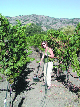
We tested the concept of using the GPR groundwave
technique to estimate water content on soils at the Robert Mondavi Winery, which
are categorized by USDA as Bale Loams. The approximately 3-acre study site is
planted with Cabernet Sauvignon grapes. The topography and water table were
fairly uniform within the study area, and all vines in the study area were subject
to the same volume and frequency of irrigation water via a drip system during
the warmest months (typically May through October).
Using 900-megahertz GPR groundwave velocity data, we estimated the electromagnetic
velocity and subsequently the dielectric constant and water content throughout
the study vineyard several times during the year. Volumetric water content obtained
using this approach at Mondavi was very accurate, as recently described by Katherine
Grote and colleagues in Water Resources Research. Their independent comparison
of the Mondavi results with conventional soil-moisture measurements also revealed
that the GPR method sampled the top 10 to 20 centimeters of the soil layer —
an important zone for plant roots.
Because the measurements were recorded as the GPR unit was pulled through the
vineyard at a spacing of 0.1 meters, the obtained soil-moisture maps provided
extremely dense information — higher density than usual. Comparison of
the water-content images and the soil-texture data at the site showed that soil
texture controls both water drainage and spatial distribution of soil moisture.
The sandy soils were consistently drier, whereas the more clay-rich soils were
consistently wetter — thus revealing significant variations in shallow-soil
properties within a single vineyard block.
The Dehlinger Winery:
MOISTURE MAPS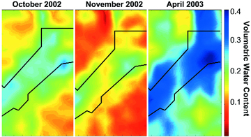
Researchers measured the average volumetric water content in the top 1 to 2 meters of soil over a 3-acre study block at the Dehlinger Winery in Sonoma County, Calif. Using 100-megahertz ground penetrating radar data, they found that the reflection surface took the shape of a buried channel across the study site. This channel-shaped feature has consistently higher water content and consistently lower grapevine vegetative growth, as revealed through both observations and these soil moisture maps. The low growth could be a response to water logging of the roots during the early stages of growth. Image courtesy of Susan Hubbard. |
Looking Forward
Our experience within the Robert Mondavi and Dehlinger vineyards suggests that
surface geophysical methods may be very useful for accurately mapping soil variations
in very high resolution. The soil-moisture patterns, often governed by soil
texture, remain the same through time, even though the soil moisture content
fluctuates with irrigation and season. Thus, once researchers and winemakers
identify patterns in the soil properties, they can develop an efficient layout
of the vineyards that allows for uniform farming that still renders high-quality
wine grapes. The work also suggests that point measurements at “hot spots”
within the vineyard may suffice for subsequent water management purposes.
Use of such precision viticulture strategies will increase as the demand for
water supplies increases. We envision taking a holistic approach — combining
soil information (estimated using geophysical methods such as GPR), with remotely
sensed canopy information and local climate data, to develop a better understanding
of the relationships between soil, vegetation and meteorological variables.
Lars Pierce of California State University at Monterey Bay has said that high-resolution
information could ultimately be incorporated into a predictive model geared
specifically toward vineyard managers. Such a model would allow vineyard managers
to develop farming strategies simultaneously geared toward improving wine-grape
quality and reducing water use.
 |
Geotimes Home | AGI Home | Information Services | Geoscience Education | Public Policy | Programs | Publications | Careers |