 After decades
of work, geologists and historians finally found evidence of an elusive earthquake,
nearly 300 years after it occurred. The magnitude-9 event that struck the Pacific
Northwest on Jan. 26, 1700, was responsible for a huge tsunami that inundated
the Pacific Northwest from southern British Columbia to northern California,
depositing thin lenses of sand over wetlands. The tsunami itself had been a
secret in the geologic record and hidden in historic records kept over centuries
in Japan, until it was unearthed by Brian Atwater, a geologist with the U.S.
Geological Survey (USGS) in Seattle, Wash., who in April was named one of Time
magazine’s most influential people of 2005 because of his research.
After decades
of work, geologists and historians finally found evidence of an elusive earthquake,
nearly 300 years after it occurred. The magnitude-9 event that struck the Pacific
Northwest on Jan. 26, 1700, was responsible for a huge tsunami that inundated
the Pacific Northwest from southern British Columbia to northern California,
depositing thin lenses of sand over wetlands. The tsunami itself had been a
secret in the geologic record and hidden in historic records kept over centuries
in Japan, until it was unearthed by Brian Atwater, a geologist with the U.S.
Geological Survey (USGS) in Seattle, Wash., who in April was named one of Time
magazine’s most influential people of 2005 because of his research.
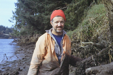
Brian Atwater has spent nearly two decades
investigating the great tsunami that swamped the coastline of the Pacific Northwest
and traveled all the way to Japan with devastating effects. Recently named one
of Time magazine’s most influential people of the year,
he, with colleagues, will publish The Orphan Tsunami of 1700 this fall.
Copyright Helen Lambourne; courtesy of Brian Atwater.
Until Atwater waded into the muddy wetlands of the Pacific Northwest more than
two decades ago, no one knew the seismic history of large earthquakes for the
region. But through careful radiocarbon dating of drowned trees, fieldwork that
documented land shifts and tsunami deposits, and other data collected since
the mid-1980s, Atwater and others have collected evidence for quite large earthquakes
in the region. Atwater published the first inkling of a very large event that
happened around 300 years ago in a 1987 paper in Science, careful not to conclude
too much, as he says there were not enough data at the time.
So when Kenji Satake of the Geological Survey of Japan and colleagues published
a paper in Nature in 1996, showing evidence that the 1700 Cascadia tsunami
reached Japan, Atwater was extraordinarily interested — so much so that
he started learning Japanese so he could examine the historic evidence firsthand.
“Learning a new language at an age of nearly 50 is not an easy task, and
Japanese is not an easy language for westerners,” Satake says. “As
a traditional, and sometimes stubborn, geologist, he would not be convinced
until he examined the data by himself,” he says. The data were not coastal
geologic sections, but rather Japanese historical documents. “A normal
person would not step further. Brian, however, was different.”
Eventually, Atwater and Satake wrote a proposal together so that Atwater could
visit Japan in 1998, to study for about a year. “I often joked that Brian
did not believe me, so he came to Japan for inspection,” Satake says. That
work paid off in part with the publication of the 2003 paper in the Journal
of Geophysical Research, which used radiocarbon dates of trees drowned immediately
after the earthquake, calculated by Atwater’s colleague Minze Stuiver.
Reflecting on the path that led him to those discoveries, Atwater, a native
of Connecticut, recalls spending summers as a backpacking group leader in the
White and Green mountains and the Adirondacks, which led him “to combine
outdoors with a career.” As an undergraduate student working at USGS in
Menlo Park, and while working on his Ph.D. at the University of Delaware, he
studied the wetlands that ring the San Francisco Bay and the marshes further
east in the San Joaquin and Sacramento river deltas.
After switching to the hard rock geology and geomorphology of northeastern Washington,
he came back to studying wetlands, moving to Seattle in 1985. Around this time,
Atwater heard a talk given by Tom Heaton, a seismologist at USGS at the time
who is now at Caltech in Pasadena, Calif. Asked by the Nuclear Regulatory Commission
to review studies for the placement of nuclear power plants in Washington, Heaton
noticed that there was no sure evidence either way as to whether the region
was due for a large seismic shock. But he spoke persuasively about the potential
for a “great earthquake” in the region, which is extraordinarily close
to the subduction zone off the Pacific coast, where the Juan de Fuca plate dives
under the North American plate, pushing it up and making it bulge.
Atwater says he immediately started to “think about what I could do.”
The bulge of the North American plate was the key, he decided, calculating that
at 3 millimeters of uplift a year, 3,000-year-old shorelines would have been
pushed up 9 meters (or around 30 feet). “So that’s what I went looking
for,” he says. “Land-level change is the heart of what I’ve been
working on.” In most places, abrupt changes in land surfaces are the main
signal of earthquakes.
Atwater is “not enamored with high-tech,” Heaton says. “His instrument
is a canoe and a hand auger,” he says, a pipe that takes “brute force”
to drive it into the ground for collecting core samples.
Atwater is adamant that all the researchers he has worked with receive credit
for their role in the tsunami and seismological research that has redefined
the seismic hazard in the Pacific Northwest. The nearby Cascadia subduction
zone had never had an extraordinarily large earthquake recorded with an instrument,
and so people had once thought the colliding tectonic plates an anomaly, Satake
said, and “without Brian, the Pacific Northwest might have been still considered
a safe place from great subduction earthquakes.”
Naomi Lubick
Back to top
 |
Geotimes Home | AGI Home | Information Services | Geoscience Education | Public Policy | Programs | Publications | Careers |