
|
Feature Hazardous Cracks Running Through Arizona Ray Harris and M. Lee Allison Another type of crack
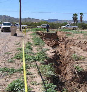
Last summer, an “earth fissure” reopened literally overnight in a residential yard in Chandler Heights, Ariz., southeast of Phoenix. The fissure is shown partially filled in a few days after it opened following heavy rain. Earth fissures can reach hundreds of meters deep and several kilometers long. Photograph is by Ray Harris. Devries and her neighbors were not alone in their experience. The same rain produced flooding that affected broad areas of unincorporated Chandler Heights. Some of the runoff found its way into an old fissure system, parts of which had been covered over for development. As water flowed through the fissure and under the capping of dirt, the surface collapsed into the underlying void, and the old fissure was reborn — the yards of Devries and her neighbors disappeared in a meters-deep chasm. That particular fissure was first reported in 1962, having formed a few years earlier. Residents who had recently moved into the area and were unaware of earth fissures were quite shocked and angry. A storm of public outrage ensued. The fissures were not news, however, to geologists. For more than 40 years, geologists have warned people about the hazards of earth fissures in Arizona, but until recently the warnings often went unheeded. In the past, earth fissures were considered an interesting phenomenon, but because they occurred mostly in undeveloped areas where few people lived, they were not perceived as a problem. But with the population expanding in recent years into areas known to have fissures, the potential for damage to property has increased, particularly with old fissures being filled in, concealing the potential risk. New residents may be completely unaware that earth fissures lurk below their yards or under their homes, but with new mapping efforts and education, short-term solutions are possible. The issue today is less a problem of earth fissures forming where people have built houses than it is of people building houses on or near fissures without knowing it. Making people aware of the issue is the first step. In the long run, however, people may need to change their groundwater usage habits to curb the problem. Sinking land An earth fissure at the surface results from large quantities of soil or sediment being washed down into a crack that may initially be only a few centimeters wide, but a hundred meters or more deep and a kilometer or more in length. The longest fissure zone mapped in Arizona has a length of more than 11 kilometers. The condition that leads to the fissures is sinking land. In parts of Arizona, that condition is prevalent. A large portion of the state lies within the Basin and Range Province, which contains deep alluvium-filled basins that are separated by long, narrow mountain ranges. Bedrock is often 3,000 meters or more below the surface. These deep basins hold large quantities of groundwater in storage, but people are pumping more groundwater than nature can replenish. Where agriculture or municipalities rely extensively or completely on groundwater, the groundwater tables have declined. In the 1940s, large-scale groundwater pumping for agriculture was widespread in the deep basins of Arizona. By the 1980s, groundwater levels in several basins had declined 150 meters or more. As groundwater tables lower, aquifer sediments lose some of the buoyant support of the water and undergo compaction. If compaction is great enough, the ground surface sinks. By 1992, in the Luke basin immediately west of Phoenix, the land had subsided about 5.5 meters. In the Picacho basin, about midway between Phoenix and Tucson, subsidence was more than 4.5 meters by the early 1980s. Compaction and land subsidence are, to a large degree, irreversible processes. Once the sediments have compacted, the capacity of the aquifer to store water is permanently diminished. Even if the water table rises, the land surface does not rebound significantly. And in most Arizona basins where the land has subsided more than a meter or two, earth fissures have developed. On the most basic level, earth fissures are tension cracks. Geologists have proposed several ways in which enough strain can be created to cause tensile failure. One mechanism involves one part of the basin subsiding more than another over a short distance. Another mechanism proposes that the viscous drag of groundwater moving through an aquifer pulls the sediments with the water. The drying out of clay-rich sediments may also affect the development of earth fissures (see sidebar below). Growing hazard Then, water entering a fissure system may channel laterally, causing underground erosion for a great distance from the point of entry. Heavy rain softens the surface material, allowing it to cave into the underlying fissure. Water running into the fissure erodes the sides and washes the material deep down into the fissure system, enlarging the original small crack into an impressive chasm. Even before they are fully developed, earth fissures can cause significant damage to infrastructure such as roads, canals, railroads and pipelines. Buildings can suffer extensive cracking. Houses have been completely destroyed by fissures that opened up beneath them. The presence of cracks in foundations and walls, however, does not necessarily indicate that subsidence or earth fissures are to blame. Expansive soil, hydrocompaction and normal settling of fill material can also produce cracks in structures. Fissures also pose a serious threat to water quality because they may serve as open conduits to the water table. Contaminants that enter a fissure may travel almost unimpeded into regional aquifers that supply drinking water. Erosion-enhanced fissures have commonly been used as illegal dumping sites for household garbage, tires, construction debris and animal waste. Reducing the risk Additionally, Arizona laws have not been conducive to reducing the risk. Until recently, land owners, developers and real estate agents were not required to disclose the presence of earth fissures on property being sold. Also, land subdivided into five or fewer parcels was exempted from state requirements for the seller or developer to conduct background geotechnical assessments. With the recent increased awareness of the problem, however, Arizona has begun responding to the growing risk from earth fissure hazards. Although the most effective mitigation for earth fissures and giant desiccation cracks is to avoid development where they are present, it is first necessary to determine their locations precisely. Unfortunately, many maps that show the locations of earth fissures are decades old. Most of those maps were made before GPS was available, are not digital, and were completed at scales of 1:24,000 or smaller, which are not adequate for the detailed planning needed by developers and local building officials. A sizable number of known earth fissures have never been mapped at more than a regional scale. Some of the existing maps are best termed as reconnaissance-level. In addition, continued groundwater pumping has produced new fissures or extended existing ones in some areas since the last mapping was done. Legislation just passed in Arizona in June and signed by the governor into law July 1, however, will fund a new fissure mapping program at AZGS. This funding will enable the survey to map in detail all fissures in the state at scales that will allow the public to accurately judge whether their properties are at risk. New mapping efforts will use high-precision GPS instruments to dramatically improve location accuracy over older, hand-drafted maps. Detailed mapping with GPS will provide effective monitoring: When an area is revisited, scientists can quickly assess how much a fissure has grown since the last visit. In addition to providing funding for detailed field mapping, the expanded fissure mapping program will provide funding to enable public access to on-demand, digital maps via the Arizona State Land Department’s Web site. This new Web service will allow users to superimpose fissure maps over other GIS layers of their choice so individual properties can be easily identified and assessed. Additionally, another new state law passed last spring now requires the seller to disclose whether fissures are known to exist on or near a parcel of land. Even with that, however, AZGS continues to hear isolated reports of landowners bulldozing over fissures or dumping layers of rock and soil over them, just prior to developing or putting the land up for sale. To aid in the communication of the hazard, AZGS is developing training sessions targeted to real estate professionals, homebuilders and local officials, to give each of them critical information to make informed decisions. The seminars include describing the nature, origin, occurrence and impacts of fissures, showing how to find and understand the fissure maps, and discussing what can be done to reduce risk. AZGS also has resurrected the Center for Land Subsidence and Earth Fissure Information, which includes expanding its Web site (www.azgs.az.gov/CLASEFI.htm) to serve as an information portal about fissures, desiccation cracks, and related geologic hazards in Arizona. The survey is also working with the Arizona Association of Counties to develop a cooperative program modeled after those in other states, in which the survey will review hazards reports submitted to the counties by developers, as counties often have little or no expertise to evaluate such reports and no funds to contract for external reviews. The reports will be added to a public state-wide hazards inventory library to better and more easily assess geologic hazards and risks on nearby lands. Human-made solutions In some ways, Pam Devries and her neighbors were lucky. They filled in the fissures in their yards and are going on with their lives. Others may not be as fortunate, if fissures open up suddenly directly under homes, businesses or roads.
Harris is a research geologist with the Arizona Geological Survey (AZGS) in Tucson, with more than 12 years of work on earth fissures, and Allison is state geologist for Arizona and director of AZGS. E-mail: ray.harris@azgs.az.gov or Lee.Allison@azgs.az.gov. Links:
|
 |
Geotimes Home | AGI Home | Information Services | Geoscience Education | Public Policy | Programs | Publications | Careers |
 Subscribe

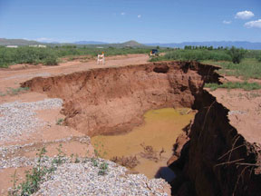
 One
warm morning last August, Pam Devries opened the front door to the four-bedroom
home she and her husband bought a year earlier in rural Chandler Heights,
southeast of Phoenix, Ariz., and found a surprise. Although the heavy
rain the night before was a welcome relief from high temperatures and
drought-stricken vegetation, it left something unwanted in its wake: a
gully 5 meters deep and 3 meters wide that had swallowed a good part of
the yards in Devries’ neighborhood and now extended the length of
the neighborhood. As she stared, horrified, at her neighborhood's new
feature, water runoff still poured into the seeming abyss. That morning
was Devries’ first experience with the little-known geologic hazard
of earth fissures — large cracks caused from groundwater depletion.
One
warm morning last August, Pam Devries opened the front door to the four-bedroom
home she and her husband bought a year earlier in rural Chandler Heights,
southeast of Phoenix, Ariz., and found a surprise. Although the heavy
rain the night before was a welcome relief from high temperatures and
drought-stricken vegetation, it left something unwanted in its wake: a
gully 5 meters deep and 3 meters wide that had swallowed a good part of
the yards in Devries’ neighborhood and now extended the length of
the neighborhood. As she stared, horrified, at her neighborhood's new
feature, water runoff still poured into the seeming abyss. That morning
was Devries’ first experience with the little-known geologic hazard
of earth fissures — large cracks caused from groundwater depletion.
 In addition to the classic earth fissure from groundwater pumping
(see main story), another type of large crack is becoming increasingly
common in Arizona: “giant desiccation cracks,” which form
when thick layers of clay-rich sediments dry out.
In addition to the classic earth fissure from groundwater pumping
(see main story), another type of large crack is becoming increasingly
common in Arizona: “giant desiccation cracks,” which form
when thick layers of clay-rich sediments dry out.