
|
 Subscribe

FEATURE
Restoring the River
Megan Sever
 Torbjörn Törnqvist |
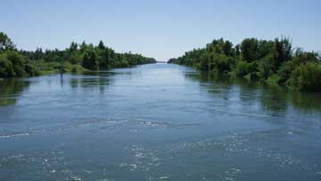
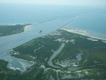
| In a natural system, the Mississippi River would find many channels into the Gulf of Mexico. |
When Hurricane Katrina barreled down on the Gulf Coast in August 2005, the immediate focus was on the storm victims who lost their lives and homes. When the levees breached shortly following the storm, the focus shifted to the region’s infrastructure. Although civil reconstruction continues to be of importance, arguably the focus has shifted yet again, to the natural — or unnatural as the case may be — ecosystem in the Mississippi Delta. New Orleans is being reconstructed, house by house and business by business. The levees and floodgates are being rebuilt to protect the city from the mighty river that both sustains and threatens it. But since Katrina struck, one thing has become clear, researchers say: Restoration of the natural system is of paramount importance to saving New Orleans in the long run, and the time to act is now.
A Disconnected Delta
The Mississippi Deltaic Plain is a 25,000-square-kilometer (2.5-million-hectare) landscape of rivers, freshwater and saltwater wetlands and marshes, low-lying forests and barrier islands. Some 6,000 to 7,000 years ago, the Mississippi River began building the present delta where it entered the Gulf of Mexico, providing water and sediment to the wetlands and building them up fast enough to counteract natural compaction. The sediment also built up and sustained barrier islands off the coast of Louisiana and Mississippi. The Mississippi Deltaic Plain experienced net growth for several thousand years. Then it suddenly started losing ground.
 Torbjörn Törnqvist |
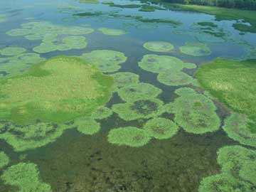
| The Mississippi Delta system includes saltwater and freshwater marshes, which provide habitat for birds, shellfish, fish and small mammals. |
A massive flood in 1927 inundated close to 65,000 square kilometers (16 million acres) of land in Kentucky, Tennessee, Arkansas, Mississippi and Louisiana, destroying 41,000 buildings and killing hundreds of people, says Virginia Burkett, an ecologist with the U.S. Geological Survey (USGS) in Lafayette, La. Following the flood, thousands of kilometers of levees were built up along the river to prevent such disasters. The river water, and the roughly 120 million tons of sediment it carries each year, was cut off from the delta. “Without sediment to replenish it, the delta is not sustainable,” Burkett says.
Since the early 1930s, the Mississippi Deltaic Plain has lost about 4,900 square kilometers (more than 1.2 million acres) of wetlands — an area the size of Delaware, according to the Louisiana Coastal Protection and Restoration Authority. The loss is directly related to the isolation of the river from the delta plain, says John Day, a retired geologist from Louisiana State University in Baton Rouge. Because the river is completely leveed, he says, most of the river’s discharge goes straight into the Gulf of Mexico, building up the Birdfoot Delta instead of the larger delta plain.
When Katrina struck, even more wetlands were lost. USGS estimates that 562 square kilometers (138,800 acres) of marsh converted to open water in the wake of the storm. Entire barrier islands were wiped out, including roughly two-thirds of the Chandeleur Island chain. Not much of the system has returned to its pre-Katrina state, Burkett says. And “the scale of natural recovery is expected to be minor compared to the losses,” she says.
 Patrick Leahy |
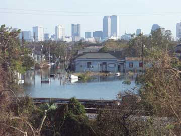
| When the levees breached in New Orleans following Hurricane Katrina, parts of the city were flooded. |
Sustaining Life
“The past and continual degradation of Louisiana’s coastal landscape will have significant ecological, societal and economic impacts on the region and the nation,” according to the Louisiana Coastal Protection and Restoration Authority. More than 2 million people, or 65 percent of Louisiana’s population, live within 80 kilometers of the coast. That area includes nearly three-quarters of the state’s economy. Nearly 15,000 kilometers of oil and gas pipelines cross coastal Louisiana, and one-third of U.S. oil and gas supplies come through there. “We’re keenly aware of the importance” of the region, Burkett says.
People are also keenly aware, Burkett says, of the importance of natural features to sustaining the built infrastructure. Wetlands, marshes and barrier islands significantly reduce the effects of strong storms. The 2005 storms were strong enough that the wetlands and barrier islands would have been inundated even without degradation to the system, Burkett says, but the levees would have been able to withstand more of the blow from the storm surge if the wetlands had been in better shape. It has long been apparent that the coast was deteriorating, she says, but since the storms struck, “people have begun to realize the relationship between their vulnerability and the natural system — loss of coast translates directly into more vulnerability.” Louisiana residents now realize that coastal restoration is of paramount importance, she says.
A Reconnected River
“Planning the restoration of the coastal landscape requires the design of sustainable ecosystems that integrate human society with the natural environment and work with rather than against natural processes,” Day and colleagues wrote March 23 in Science. A number of different options exist for working with the natural system, but all of them involve reconnecting the river to the delta plain via river “reintroductions” or diversions, he says.
 NASA/EROS USGS Data Center |
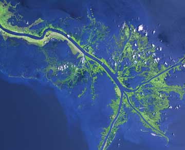
| Left unchecked, most of the Mississippi River today would flow through the Atchafalaya, well above New Orleans. Instead, the river system is engineered so that less than 30 percent of its water flows through the Atchafalaya, with the remainder going through the main channel and out to sea via the Birdfoot Delta. Millions of tons of valuable sediment (shown here in lighter blue) are lost to sea each year because of this engineering. |
It is ironic that diversions are what everyone is talking about, Day says, because although scientists have been calling for them for decades, in the past “if you were for diversions, you were looked at as if you were from Mars.” Now, he says, “everyone understands the necessity.” Indeed, following the 2005 storms, “a window of opportunity opened for diversions,” Burkett says. “From a scientific perspective, there’s very strong consensus on what needs to be done, and now public consensus seems to be matching.”
Diversions mean breaking through some of the levees and allowing the Mississippi River to find other paths to the Gulf of Mexico. River water and sediments would be allowed to overflow banks into wetlands, thus rebuilding them. The challenge is that by diverting water into wetlands and other channels, it is taken away from other sites that rely on the current channel. Towns that rely on fishing, oil refining and river barge traffic in the lowest parts of the current delta would likely be cut off entirely from the river, thus destroying those industries, in addition to cutting off those areas’ freshwater source. Although consensus may be in favor of diversions, a lot of political forces are wrangling over exactly where to put them, Day says.
Such diversions could be created both up and down river from New Orleans, Burkett says, but the highest-volume diversions would likely be south of New Orleans. There, large flows can be accommodated by the coastal environments, and the restoration efforts would likely have the greatest benefits in terms of protecting New Orleans from storm surges, while also enhancing fish and wildlife habitat. As an added benefit, those areas are more sparsely populated, so fewer people would be affected.
 Torbjörn Törnqvist |
| Channels and shipping canals have been engineered on the lower Mississippi River to enable shipping access to ports along the river. Many of the restoration proposals involve closing some of these channels. |
Two diversions on the Mississippi are already demonstrating how well diversions can work to restore wetlands, Day says. About 40 kilometers north of New Orleans is the Davis Pond Freshwater Diversion, which lets freshwater and a minor amount of fine-grained sediment and nutrients into Barataria Bay. The U.S. Army Corps of Engineers suggests that over the next 50 years alone, the diversion will benefit more than 3,100 square kilometers (310,000 hectares) of marshes and bays. Another project, the Caernarvon Freshwater Diversion, is 24 kilometers downriver from New Orleans and has been in place since 1991. It was designed to divert freshwater into Breton Sound. So far, it has increased marshland by nearly 6 percent a year.
Although these are freshwater diversions (meaning they pull water off the top of the river rather than the bottom, where heavier sediment loads are) and thus do not provide a lot of sediment to the wetlands, they are still beneficial, Day says. Over the past few decades, Charles Demas, director of the Louisiana Water Science Center at USGS in Baton Rouge, and his team have been measuring water discharge rates at various points along the Mississippi River and throughout the Gulf Coast. Researchers can determine sediment grain size discharge rates as well, Demas says, by targeting different points in the water column. “We can tell you what’s going through there, but we need wetland ecologists to tell us what grain size is ideal for a marsh ecosystem,” he says.
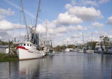 www.flickr.com/photos/whalt |
| Shrimping is one of the Mississippi Delta’s major industries. Wetland degradation has hurt the industry, but some wonder if restoration efforts might further harm the industry. |
Restoring the river system includes more than just diversions, however. It also involves restoring wetlands and barrier islands — the entire hydrological system of the delta, Day and colleagues wrote in Science. First of all, “we need to get more sediment into the wetlands,” says Jeffress Williams, a geologist at USGS in Woods Hole, Mass. One proposal to “jumpstart” wetland restoration is to pump dredged sediment into the wetlands, Demas says. Another discussion involves pumping sand from offshore to construct new barrier islands where natural ones once existed. Closing deep navigation channels, filling in other canals, installing locks, trapping sediments and removing some of the levees are also under discussion, Demas says. “There are all sorts of options,” he says.
Political Will
“The atmosphere for proactive fixing of this system is much greater now than it was before Katrina struck,” Burkett says. “New Orleans can be saved if actions are taken quickly enough and if the right actions are taken.”
On June 1, the start of the 2007 Atlantic Hurricane Season, the Louisiana Coastal Protection and Restoration Authority released its “master plan” for the restoration of the region. The plan is designed to be the guide for all coastal protection and wetland restoration projects over the next several decades, so that any single project or restoration plan must be consistent with the plan. The master plan includes everything from levee rebuilding to diversions and restoring barrier islands. The Louisiana legislature already approved the master plan, and approved a budget that directs funds into restoration projects.
“Politically, any projects will take some time,” says Torbjörn Törnqvist, a geologist at Tulane University in New Orleans. “Scientists need to use that time to determine the best scientific solutions,” he says. “It’s the only way New Orleans will survive in the long run.”

