
|
 Subscribe

FEATURE
Travels in Geology: Two Options in Oregon
Travels in Geology: Finding Fossils in John Day
Travels in Geology: Roving Oregons dunes
Editor’s Note:
As anyone who has ever spent much time in Oregon knows, there’s something for everyone — especially geologists and those who love the outdoors.
Eastern Oregon combines vast, hot deserts that gradually rise into high mountain plateaus with occasional expansive lava beds as far as the eye can see. Other-worldly painted hills rise above multimillion-year-old fossils and rolling wheat and barley fields that edge into deep gorges filled with rushing rivers. Eastern and Western Oregon are sharply divided by the Cascade Range, home to famed volcanoes, such as Washington’s Mount St. Helens, Oregon’s Mount Hood and California’s Mount Shasta. This volcanic chain, which runs from British Columbia into California, towers above the rest of the state, offering everything from skiing and mountaineering on Mount Hood in the north to hiking around the iconic volcanic Crater Lake in the south.
Western Oregon is as varied as Eastern Oregon. The fertile Willamette Valley — the end point for the Oregon Trail and home to rolling hills filled with a blend of vineyards, farmlands and the vast, dense coniferous forests that have been extensively logged for more than a century — stretches to the Coast Range, which sharply descends to the Pacific. Along the 650-kilometer-long coastline run vast intertidal zones, sharp cliffs that host some of the country’s largest sea caves and a series of giant sand dunes. You could spend a lifetime here and not see everything.
Are you traveling to or through Oregon this summer? Here are tales of just two of the geologically significant places to visit in the state: John Day Fossil Beds in Eastern Oregon and the dunes of the West.
These pieces were previously published on Geotimes online, but have been edited to fit the space. The full-length articles can be found on Geotimes online in our “Travels in Geology” section, at www.geotimes.org/Travels.html.
Mary Caperton Morton
 Mary Caperton Morton |
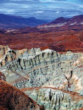
| The painted hills rise above the Sheep Rock Unit of the John Day Fossil Beds National Monument in Eastern Oregon. |
On the surface, the painted hills of the John Day Fossil Beds National Monument in Eastern Oregon are spectacular, but it is what lies beneath the rolling red landscape that makes this desert region famous. Buried within the underlying layers of volcanic tuff are the world’s richest fossil beds from the Cenozoic Era, also known as the “Age of Mammals.” Fossil beds that span more than a few million years are rare. Yet, these layers extend across more than 40 million years of history, making the beds at John Day one of the most complete records of ancient life anywhere on Earth — and definitely worth a visit.
The John Day fossil beds lie in the rain shadow east of Oregon’s two towering mountain ranges, the Coast Range and the Cascades. The mountains to the west are what make this region an arid desert today, but the layers of rock that formed the fossil beds were actually deposited from ancient volcanic eruptions to the east long ago. Thirty million years ago, prevailing winds blew tons of ash onto John Day’s once lush grasslands, marshlands and forests, burying foraging rhinos, horses and giant ground sloths. Now, every summer, vicious thunderstorms sweep through the region, eroding the fragile aquamarine-colored claystone and washing fossils from more than 100 different species of mammals from the steep hillsides.
The fossil beds are protected within the John Day National Monument, which is divided into three separate parks: the Painted Hills, Sheep Rock and the Clarno units. To visit the beds, start at the Sheep Rock Unit, which lies just northwest of Mitchell, Ore., about two hours east of Bend. Here you can visit the park’s main facilities and fossil museum at the Thomas Condon Paleontology Center. The museum features many beautiful fossils, interactive displays, audiovisual presentations and even a window into the park’s paleontology lab where scientists prepare and study fossil specimens. Knowledgeable park rangers and paleontologists give regular talks about the displays and geology of the region and are always willing to recommend the best hikes to see the fossil beds firsthand.
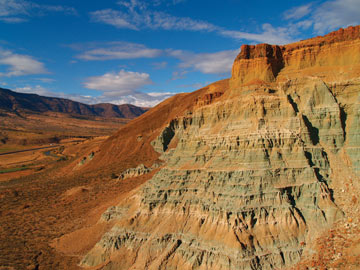 Mary Caperton Morton |
| Over millions of years, volcanic ash deposited at John Day has turned into fossil-rich blue-green claystone. |
Hiking the Blue Basin Overlook Trail, combined with the shorter, adjoining Island in Time Trail, is the best way to experience both the intrepid geology and spectacular scenery of John Day. Both trails begin five kilometers west of the museum. The four-kilometer Blue Basin Trail is a loop, more easily hiked clockwise, that ascends to the top of the basin and overlooks the blue-tinged, fossil-rich outcrop where you will find most of John Day’s fossils. The hike to the top is mildly strenuous, but rewarding. From there the views of the painted hills and surrounding landscape are breathtaking. The vantage point also provides a unique view overlooking the 40 million years of history preserved within the Blue Basin below. The trail then descends into the basin itself, where it meets up with the Island in Time Trail and explores the fossil outcrops up close. Several specimens, including a turtle shell and a saber-tooth-tiger-like oreodont skull, are protected in situ under plastic capsules where they were found protruding from the hillside. You might also run into a park paleontologist combing the walls of the Blue Basin for newly exposed fossils.
If you are one of the lucky visitors who finds a fossil, don’t touch it! Make note of its location and report the find to a park ranger as soon as possible. Recording the exact location of the fossil within the layers of strata is just as important as recovering the fossil itself and best left to a professional. While the large mammal fossils are the most exciting relics found at John Day, the preservation of the changes in forests and grasslands in an unbroken sequence also makes these fossil beds remarkable. This is one of the few places in the world where scientists can study the evolution of an ancient habitat along with the forces that brought sweeping ecological changes. Four distinct ecological eras divide the strata at John Day, each with its own unique set of fossils, which is why recording the exact location of a fossil find is imperative.
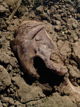 Mary Caperton Morton |
| This oreodont skull, displayed in situ along the Island in Time Trail, is just one of more than a hundred different types of mammal fossils found at John Day. |
The oldest rocks at John Day, deposited between 50 million and 35 million years ago, make up the Clarno Formation, best preserved at the Clarno Unit. A bounty of fossilized nuts, seeds, leaves and other woody structures, including remains from a banana tree, indicates that this region of Oregon was covered by an evergreen tropical forest during this time period. Fossils of brontotheres and amynodonts — giant browsers that resemble horses and rhinos — neither of which left descendants to modern times, also rest here. The Clarno strata give way to the John Day Unit strata around 37 million years ago, marked by the invasion of deciduous forests into the region. Recognizable mammals appear here, including ancient relatives of wolves, pigs, large cats, horses, camels, rhinos and rodents. Thick deposits of basaltic lava mark the interval between the John Day and Mascall formations, starting around 20 million years ago.
After about 5 million years, the area began to regrow into warm, wet savanna grasslands with pockets of hardwood forests. Animals that lived here at that time include massive grazers like gomphotheres (elephant-like creatures), rhinos and extinct bear-dogs. The youngest strata making up the Rattlesnake Formation began around 8 million years ago, when the climate became much drier with the rise of the great modern mountain ranges to the west, killing off the forests and allowing the grasslands to expand. Grazing mammals like horses, pronghorns, sloths, rhinos, camels and peccaries dominate the fossil layers during this time period.
Dozens of hiking trails snake through the park and river rafting and fishing for bass and trout on Service Creek are also popular ways to enjoy this beautiful region of Eastern Oregon. Whether you are a fossil buff, a maven of deep geologic history, a river rat or a lover of spectacular desert scenery, the John Day fossil beds have something to offer.
To get to John Day, which is in the middle of the vast Eastern Oregon desert, drive northeast from Bend on scenic Highway 26. The route passes many notable natural attractions, including Smith Rock State Park, a rock climber’s paradise. Rustic park service campgrounds abound south of the highway, and Clyde Holliday Recreation Area, near the town of John Day, has full RV hookups, yurts and cabin rentals. Desert temperatures can be stifling in the summer and frigid in the winter so try to visit for a few days in the spring or fall.
Links:
More images of John Day Fossil Beds, Oregon by Mary Caperton Morton
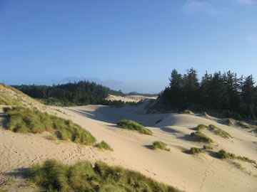
| Oregon Dunes National Recreation Area hosts dunes that are nearly 200 meters high. |
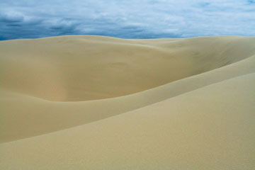
Over the past couple of years, the Mars Exploration Rovers have photographed the vast dune fields on Mars. Scientists analyze these dunes, which are only a meter tall, to learn about the geologic processes that shape the red planet’s landscape. But you don’t need to leave Earth to get some out-of-this-world glimpses of dunes. The United States is home to many remarkable dune fields, including Great Sand Dunes, White Sands, Sleeping Bear Dunes, Jockey’s Ridge and Oregon Dunes. Oregon Dunes is the largest coastal dune system in North America. Although visitors are more likely to see dune buggies than rovers, the landscape looks as alien as any landscape on Mars.
South of Florence and north of Coos Bay along the Pacific Coast, Oregon Dunes National Recreation Area stretches 68 kilometers along Oregon’s coast. The area contains dunes up to 183 meters high and a wide variety of dune features. Oregon Dunes is easily accessible from Highway 101, part of the Pacific Coast Scenic Byway, and observant drivers can catch glimpses of the dunes as they speed along. But the dunes are best explored on foot, so stop and walk around if you can.
The many rivers flowing westward from the Oregon Coast Range, which runs from southern Alaska to California, delivered a large proportion of the sand that is now incorporated into the dunes. Scientists, however, are uncertain about the mechanisms that turned the sand into dunes. One thought, says Darren Beckstrand, a geologic consultant who wrote his master’s thesis on the Oregon Dunes while at Portland State University, is that retreating beach sand caused by sea-level rise over the last 12,000 years accumulated as it moved inland, forming the dunes. The competing hypothesis, favored by Beckstrand, is that the sand was blown inland from the continental shelf during periods of low sea level over the last 2 million years.
 John Kercher |
The modern geologic features of the dunes are as interesting as their history, says Gayle Gill, an information assistant with the National Forest Service. In the winter, visitors can find rare occurrences of wind-sculpted ridges called “yardangs” among the dunes. Intrepid hikers can also explore a field of heavily vegetated parabolic dunes in the Winchester Bay area. The tallest dunes are located along the John Dellenback Trail, previously called the Umpqua Dunes Trail. For those who want to explore the dunes but loathe the idea of slugging through soft sand to see anything, a dune buggy is the perfect alternative.
Dune buggy/ATV rentals and guided trips are available at most of the surrounding commercial hubs — Reedsport, North Bend and Florence. The Spinreel Campground, about 15 minutes south of Reedsport, is the center of most off-road vehicle activity. About 50 percent of the dunes are open to off-road traffic, but the vehicles are restricted to areas that are not environmentally sensitive.
Sometimes, however, the reverse is true: The U.S. Forest Service has opened up vegetated areas to off-road vehicles for ecological reasons, Beckstrand says. For example, dune buggy traffic can help combat the invasion of non-native species of European beach grass by keeping the grass populations in check. “The areas of open sand have been rapidly decreasing over the last 30 to 40 years,” he says.
The dunes are also home to some of the best golfing in the United States, should that be your thing. Hang-gliding, horseback riding, fishing, hiking and camping are also favorite activities. Consider planning a trip soon. August is the peak tourist season, but Oregon’s mild winters make the dunes enjoyable year-round. September through October, with small crowds and early fall temperatures, may be the best time to visit. There is a day-use fee of $5 at most of the trailhead parking lots, but compared to the $1 billion NASA paid to drive its rovers through the Martian dunes, it’s chump change.
Links:
Oregon Hiker at www.flickr.com/photos/oregonhiker

