Feature
NATURAL HAZARDS: DAMAGE CONTROL
Watching for the Waves: Q&A with David Green
Plus! The top natural hazards news stories of 2006
 Tsunamis, earthquakes, hurricanes and landslides: The past few years have witnessed multiple large-scale natural disasters that have tested people’s ability to endure and rebuild. As a result, many scientists have sought ways to predict and protect against these natural hazards, from research on how to foretell strong earthquakes to rethinking how to engineer sturdier levees. Tsunamis, earthquakes, hurricanes and landslides: The past few years have witnessed multiple large-scale natural disasters that have tested people’s ability to endure and rebuild. As a result, many scientists have sought ways to predict and protect against these natural hazards, from research on how to foretell strong earthquakes to rethinking how to engineer sturdier levees.
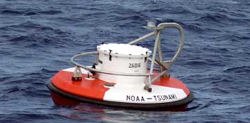
Surface buoys receive information from pressure recorders at the bottom of the ocean. They are part of a real-time monitoring system that could provide early warnings of an imminent tsunami. Photograph is courtesy of NOAA.
As for tsunamis, the U.S. National Oceanic and Atmospheric Administration (NOAA) has ramped up its efforts to expand the U.S. tsunami warning system, and is part of an international effort to expand tsunami warning systems around the world. David Green, NOAA’s Tsunami Program manager, spoke with Geotimes reporter Carolyn Gramling on the newest technologies, systems and collaborations that scientists are devising to send swifter warnings that potentially dangerous waves are on their way.
CMG: What lessons have we learned since the December 2004 tsunami?
DG: [We learned] awareness that it’s not such a rare event. The one that we saw was certainly of a magnitude that none of us had ever seen in our lives, but now we’re starting to hear more about them in the news. We also had a reminder [in July] in Indonesia (see Geotimes online, Web Extra, July 17, 2006). In that event, the Pacific warning system was responsible for collecting whatever information we could find, but while there have been advances, not all the stations are in yet (see Geotimes, November 2006).
We’ve made great progress on observation and warning technologies, but we have a long way to go. We have identified the focal points to provide the information to, however — whenever an event occurs, we need to know whom to contact. Education and outreach are incredibly important. We’re improving warning systems through the Caribbean, South Pacific, North Atlantic, Mediterranean. Not all of the systems are mature, but they will be over the next few years.
CMG: How are the existing observation systems currently being updated?
DG: We’ve had a system in place for many years, but it was a small system. We only had six stations in 2004, which were good for areas that we already knew had been exposed to a tsunami. [In the past,] we were looking at a variety of observational tools — deep-ocean sensing is one that we pioneered at NOAA. What we’ve done now is expanded that network: We used to monitor once a day or a week, but now we have a real-time nearshore monitoring network, have new ways of doing bathymetry and topography — ships and aircraft to monitor coastlines — and have combined [all of] that with new satellite capabilities for communication. So we’re getting much better characterization than we ever had before.
CMG: What are the key elements needed to create a more effective tsunami warning system?
DG: What’s needed is an end-to-end system, with the technology and science to detect [a tsunami], to watch it as it propagates, and to look at and understand how it impacts exposed areas. What we have to do is turn all the observations and the data into warning information.
CMG: And what are some of the newer technologies and approaches that NOAA is looking into, to get speedier detection and relay information?
DG: There are two aspects to observational technology and data. One is that you might need a unique type of data, and a very unique tool to measure it. But to provide warnings in real-time, you need a lot of different types of information very quickly. So we’re looking into [using] buoy offshore networks and deep-ocean sensing as multiuse platforms for ocean pressure monitoring, seismic monitoring and GPS sensing (see Geotimes, August 2006).
CMG: Where do you see the most hope right now for establishing the earliest possible warnings?
DG: Deep-ocean sensing is the most mature and the most ready to move forward. That’s where we’ve put our emphasis.
CMG: What does deep-ocean sensing do that other types of detection cannot do?
DG: One of the limitations of seismic monitoring is that it tells you something happened, but not that there’s been a tsunami. Seismic data is what we see first — that’s why the density of broadband, strong motion-sensing stations is critical. But combined with that, we’re looking at something that can really tell us that the water has been displaced, that the waves are propagating — that type of technology. The technology that we currently have, called DART for Deep Ocean Assessment and Reporting of Technology, is a pressure sensor that sits at the bottom of the ocean and can detect a significant displacement in real time. The intention is to give everyone an hour’s lead time for a deep-ocean event; the information is relayed within minutes.
CMG: How has NOAA been working on updating the U.S. tsunami warning system?
DG: [Before the December 2004 tsunami,] we had six DART stations around Alaska and Hawaii; by the end of this year, we should have 25 stations around the Pacific, on our way to a total of 32. We’ve also got five deployed in the Caribbean for the first time. And we’ve expanded our staffing at the 24/7 warning stations.
CMG: What’s the long-term plan for tsunami warning systems?
DG: The long-term vision is about forecasts that really address the risk. We’re trying to evolve from a warning to a system that can forecast within seconds and minutes where the event has occurred and what’s going to happen over the next hour or few hours, and can help people understand what decisions to make.
That end-to-end system — from observations to modeling to readiness of communities — is critical, and also relies on federal, university and industry partnerships. We’re dealing with the type of event that’s not in any one person’s backyard.
Links:
"Quake off Java triggers deadly tsunami," Geotimes online, Web Extra, July 17, 2006
"Guarding Against Tsunamis: What Does It Mean To Be Ready?" Geotimes, November 2006
"Faster tsunami warnings with GPS," Geotimes, August 2006
Back to top
|

 Subscribe
