Geotimes
Travels
in Geology February
2004
Cave crawling in France
Long before the Louvre housed its first painting, before Caesar conquered the
Gauls, before humans first fermented the grape to make wine, even before prehistoric
people ever daubed paint on a cave wall, France began to roll over a hotspot.
Formerly submerged areas of southwestern France were uplifted, exposing vast
swathes of continental shelf and shoreline to the ravages of weather and volcanism.
Beginning at the edge of the old limestone continental shelf, the geologically
inclined traveler can trek all the way to the granite of the continent proper,
taking in everything along the way from cave paintings to volcanoes to the excellent
local wines. For the full trip, it will take about a week to 10 days.
Renting a car is essential to this geologic adventure, as some of the distances
between major destinations are long. Once you've arrived in an area, however,
bicycling is the ideal way to scout out the local geology. Many lovely hotels
as well as bed and breakfasts rent rooms in the larger towns, or you can stay
at the ubiquitous campsites scattered throughout the region. If you do decide
to camp, bring gear for all weather, as the climate is variable and, even in
the summer, can vacillate from hot and dry to cold and rainy from one day to
the next.
Starting in Paris, drive south on Rte. E09 across table-top flat plains. The
landscape breaks into rolling hills just as you hit Limoges. As you continue
to the south past Perigueux, swing a bit to the southeast and you will arrive
at Les Eyzies de Tayac, a charming town between the Vézère and
the Dordogne rivers. Located at the epicenter of duck farming country, Les Eyzies
is a must for foie gras fans. While you're there, be sure to stroll along rue
Cromagnon, the street that gave Cromagnon man his name. The area is also home
to many caves of both historical and geological significance.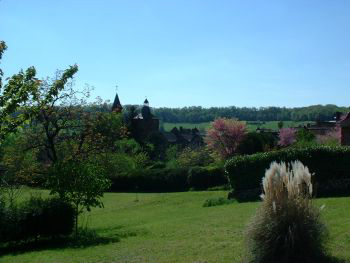
One of the most impressive caves is Font de Gaume. A limestone
cave carved by water, it is one of the last caves with colored paintings that
is still open to the public. Running bison, wild horses and the famous kissing
deer fantastically adorn the walls.
A bit further along the road is Les Combarelles, another not-to-be missed cave,
filled with prehistoric art created by etchings instead of paint. Also near
Les Eyzies de Tayac is Roque St. Cristophe, a complex of
cliff shelters inhabited almost continuously from prehistoric times through
the Middle Ages. Look closely for shellfish fossils in the walls alongside medieval
graffiti.
Collonges la-Rouge, pictured at right,
is deep in the heart of central France in the Limousin region — a region
reputed as a cradle of romanesque art. Courtesy of Conceze.com.
From Les Eyzies, drive a few hours east to Rocamadour,
the home of more modern cave dwellers. A historic town built into an anticline
in a limestone cliff, Rocamadour has shops, restaurants and even people's homes
with caves in the cliff as interior rooms. From the upper levels of the town,
gaze out across the valley for quite a view. You can see the unmistakable signs
of faulting: The trees in the forest are clearly offset in straight lines.
Before you leave Rocamadour, be sure to grab a bottle of the local vintage.
Some connoisseurs claim they can taste the transition from limestone to sandstone
to volcanic soils in the wines of the region. To test their taste buds, it might
not be a bad idea to pick up a bottle every so often throughout your trip.
If you drive east from Rocamadour, stop when you get to Padirac
and tour the local cavern. Buy your tickets early if you plan to go on a weekend,
as it can become quite crowded. A sinkhole opened the surface, leaving a pool
103 meters below the ground surface. As you float through the water-filled cavern
by guided boat, keep your eyes peeled for the gorgeous karst features and be
sure not to miss the largest known stalactite in France at 75 meters tall.
 North
from Padirac is the lovely town of Collonges la-Rouge, built
entirely of red sandstone, a dead giveaway that you've reached the ancient beach.
It's a good stop to eat lunch and break up the long drive to the base of Monts
du Cantal, a massive composite volcano well worth exploring by car or on
foot. Poking around a bit in the charming towns dotted over the volcano will
reveal pillow lava, cooling joints and a profusion of rhyolite rock. At the
very top is Puy Mary, a peak 1,630 meters above sea level. It gives an unparalleled
view of the old caldera. Glaciers have carved their mark here, leaving horns,
troughs, circs, arêtes and morrains.
North
from Padirac is the lovely town of Collonges la-Rouge, built
entirely of red sandstone, a dead giveaway that you've reached the ancient beach.
It's a good stop to eat lunch and break up the long drive to the base of Monts
du Cantal, a massive composite volcano well worth exploring by car or on
foot. Poking around a bit in the charming towns dotted over the volcano will
reveal pillow lava, cooling joints and a profusion of rhyolite rock. At the
very top is Puy Mary, a peak 1,630 meters above sea level. It gives an unparalleled
view of the old caldera. Glaciers have carved their mark here, leaving horns,
troughs, circs, arêtes and morrains.
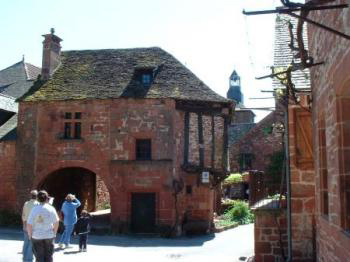
Collonges la-Rouge is routinely called
one of the most beautiful villages in France, largely because the entire village
is constructed of red sandstone from an ancient beach. Courtesy of Conceze.com.
When you finish exploring Monts du Cantal, you can head to the series of volcanoes
just northwest. Puy de Barme is a cinder cone covered in scoria. Puy de Dome
is a trachite dome volcano, with evidence of pyroclastic flows. In July and
August, hikers will be rewarded with fields of gold and purple wildflowers at
the summit. From Puy de Dome, driving just a bit further east will reveal outcrops
of granite along the road across from the hamlet of Gergovie. At last, you'll
hit the continent.
To reward your long week of cave crawling and volcano traipsing, stay over
in la Bourboule. Neo-Byzantine thermal baths like this one run all the way up
to Vichy. La Bourboule is the perfect spot to relax, enjoy the town's famously
clear air and contemplate the geology that has shaped this glorious region of
southwestern France.
Kimberly Krieger
Geotimes contributing writer
Links:
France-at-Random
tourism
Font
de Gaume
Roc
St. Cristophe
Rocamadour
Collonges
la-Rouge
Monts
du Cantal
Padirac
Read
more Travels
in Geology.
Back to top
