
 In
quick succession, a magnitude-9.0 earthquake struck offshore of Sumatra on Dec.
26, followed by tsunami waves that traveled across the Indian Ocean to overwhelm
villages and beaches in Thailand, Malaysia, Somalia, India and elsewhere. As
of Jan. 14, more than 155,000 people had been reported dead, with thousands
of people still missing, and disease threatening to kill thousands more.
In
quick succession, a magnitude-9.0 earthquake struck offshore of Sumatra on Dec.
26, followed by tsunami waves that traveled across the Indian Ocean to overwhelm
villages and beaches in Thailand, Malaysia, Somalia, India and elsewhere. As
of Jan. 14, more than 155,000 people had been reported dead, with thousands
of people still missing, and disease threatening to kill thousands more.
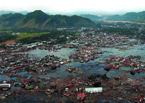
A village along the coast of Sumatra is in ruins after an earthquake and tsunami
struck off the coast on Dec. 26. This photo was taken by U.S. Navy helicopters
that were conducting humanitarian operations in the area. Image courtesy of
U.S. Navy.
The earthquake — the fourth largest to be documented by seismometers in
the last 100 years — was centered 10 kilometers below the ocean on a thrust
fault that sits below the Andaman and Nicobar islands. The fault forms the Sunda
Arc, skirting the western edges of Sumatra. “The fault plane itself was
about 1,000 kilometers long and probably at least 100 kilometers wide, [forming]
a dipping rectangle that then moves,” says Stuart Sipkin, a seismologist
at the U.S. Geological Survey’s National Earthquake Information Center
in Golden, Colo. “That’s a lot of mass.”
The shift of so much crustal weight probably caused a miniscule though noticeable
jerk in Earth’s spin, as the planet shifted with the fault movement, and
NASA scientists measured a 2.5-centimeter shift of the North Pole. The total
vertical and horizontal displacement on the thrust fault probably was at least
15 meters, Sipkin says. The jerk of the continental crust above pushed the ocean
water, and set off tsunami waves reportedly up to 14 meters (40 feet) high that
traveled at speeds of several hundred miles per hour, wreaking devastation in
the region.
Seismologists studying previous large earthquakes in the region — such
as an 1833 event, estimated to be a magnitude-8.8 to magnitude-9.2 — say
that massive tsunamis in the region should not be surprising, though historic
reports of such events are sparse. “Even in 1941, there was a large event
in the Andaman Islands, and it appears that at the time of this event, about
5,000 people died in India from what was described as a ‘storm surge,’”
says Phil Cummins of Geoscience Australia. That may have been an earthquake-generated
tsunami, but the published evidence is “very sketchy,” he says.
Cummins, who has been modeling the tsunami threat in particular for western
Australia, emphasizes that the Sunda Arc off of Sumatra is very similar to relatively
young subduction zones in Chile, Cascadia, the Aleutians and southwest Japan,
where magnitude-9 earthquakes have occurred before — and have generated
extremely large, damaging tsunamis. This event, he says, should not have been
a surprise.
Nevertheless, the Indian Ocean region has no tsunami warning system in place.
Also, Sipkin says, “the Indian basin is probably one of the least-best
covered” with seismometers, due to a combination of geographic and political
obstacles. And even though scientists in Hawaii and elsewhere saw the indications
of a huge earthquake, they had no way of sending a warning about an incipient
tsunami. Scientists say hopefully the magnitude of the destruction following
the Dec. 26 earthquake and tsunami will galvanize political will to establish
an international system, like the one in the Pacific. Last month, the United
Nations sponsored a meeting to discuss establishment of such a system for the
Indian Ocean.
Geoscientists won’t know exactly what happened in the Indian Ocean event
until they can get into the field, says geologist Gary Greene of the Monterey
Bay Aquarium Research Institute, Moss Landing Marine Laboratories. He says a
ship-borne geophysical laboratory should be deployed to check out the rupture,
to measure exactly what happened during the earthquake and to check for slope
failure. “The shallow slope areas in the vicinity of the epicenter and
fault rupture may have been destabilized from the earthquake and could possibly
fail in the future,” Greene says.
Additionally, scientists need to study onshore tsunami deposits, he says, to
determine how high and how far the waves traveled inland and if there were multiple
tsunami events — from the one-two punch of the earthquake and then from
possible underwater slope failures. Like dropping a pebble into water, Greene
says, one large earthquake event can trigger a series of waves that are part
of the same tsunami. Adding underwater landslides to the mix, he says, “you
would have another tsunami.” Modelers will be checking different scenarios
to see what exactly generated the destructive waves in this disaster.
In the meantime, Sipkin says that the region will continue to experience aftershocks
for several months, and maybe even up to a year or so. “They will continue
with slowly decreasing magnitude over the next few months,” he says. In
the week following the earthquake, dozens of magnitude-5 to magnitude-7 earthquakes
shook the area.
Naomi Lubick
Links:
"Devastation
in the Indian Ocean," Geotimes Web Extra, Dec. 27, 2004 (updated
Jan. 3, 2005)
Back to top
 |
Geotimes Home | AGI Home | Information Services | Geoscience Education | Public Policy | Programs | Publications | Careers |