
 Thirty-seven
glaciers line the landscape of Glacier National Park in northwestern Montana.
All are rapidly retreating, so if you'd like to check out a glacier in the lower
48 states, you might want to go soon. And winter is a beautiful time to visit.
Thirty-seven
glaciers line the landscape of Glacier National Park in northwestern Montana.
All are rapidly retreating, so if you'd like to check out a glacier in the lower
48 states, you might want to go soon. And winter is a beautiful time to visit.
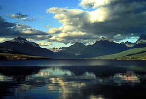
Pictured at right is Lake McDonald along Going-to-the-Sun Road in Glacier National Park (the only road that cuts through the entire park). The Continental Divide rises in the distance. Hiking and horseback riding are good ways to view the park's sights in the summer. In the winter, most sights are only accessible via snowshoes or cross-country skis. All photos courtesy of the National Park Service.
Established as a national park in 1910, the world's first international "peace" park (with Canada's Waterton Park) in 1932 and a World Heritage Site in 1995, Glacier National Park's geologic and ecologic significance is internationally recognized. The park, with more than 1 million acres (1,583 square miles), welcomes around 2 million visitors per year, most of whom visit in the summer months. It hosts 653 lakes and 563 streams — great for fishing (with a permit) and boating — and the Continental Divide (the drainage divide that separates water draining east into the Mississippi or Hudson and water draining west into the Pacific) runs more than 100 miles right through the park.
 Few
roads traverse the park, so your best bet for seeing the sights is going to
be by foot, ski, snowshoe, bike or horseback. There are more than 700 miles
of maintained trails, and hiking, backpacking, horseback riding and bicycling
are some of the most popular activities. Two other popular activities are snowshoeing
and cross-country skiing, which are especially important in the winter, when
snow in the upper altitudes can be 10 to 15 feet deep and is usually around
2 to 3 feet deep at lower elevations. February and March are perfect months
for those activities, especially if you happen to be headed to Montana for skiing
at the terrific Big Mountain Ski Resort, from which you can see into the park.
Snowmobiling is not allowed anywhere in the park, and most of the interior roads
are closed due to heavy snow, so the park offers a level of solitude unequaled
at most parks across the country.
Few
roads traverse the park, so your best bet for seeing the sights is going to
be by foot, ski, snowshoe, bike or horseback. There are more than 700 miles
of maintained trails, and hiking, backpacking, horseback riding and bicycling
are some of the most popular activities. Two other popular activities are snowshoeing
and cross-country skiing, which are especially important in the winter, when
snow in the upper altitudes can be 10 to 15 feet deep and is usually around
2 to 3 feet deep at lower elevations. February and March are perfect months
for those activities, especially if you happen to be headed to Montana for skiing
at the terrific Big Mountain Ski Resort, from which you can see into the park.
Snowmobiling is not allowed anywhere in the park, and most of the interior roads
are closed due to heavy snow, so the park offers a level of solitude unequaled
at most parks across the country.
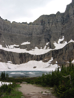
Iceberg Lake, at left, is a tarn (a glacially carved lake) that sits in a cirque (a steep-walled mountain often at the head of a glacial valley) that was carved out long ago. Snowfields (remnants of glaciers) at the head of the lake are remnants of a glacier that once occupied this basin. Icebergs still float on the lake in springtime. In the summertime, the 4.5-mile-hike up to the lake is filled with alpine flowers.
A ski or snowshoe trip along Going-to-the-Sun Road, which is a National Historic Landmark and one of the most scenic roads in North America, is a great option, according to park rangers. The road is closed to cars from September or October until snowmelt, usually in June. Whenever you visit the park, traveling along this road — the only road to cut through Glacier National Park — is a must. Several short hiking trails branch off from the road, which could be snowshoed or skied in the winter.
The trek along the 50-mile-long Going-to-the-Sun road takes you from West Glacier (an outpost), across the Continental Divide all the way to the east side of the park where the Great Basin begins. You travel through diverse alpine environments: past glacially carved and fed Lake McDonald (the largest lake in Glacier and from which you can see the Continental Divide towering in the distance), through swamps where moose sightings are frequent, to Logan Pass at the Continental Divide. In the summer, rangers lead hikes from the visitor's center at Logan Pass. The road then heads down the eastern side of the divide, passing St. Mary Lake (almost the size of Lake McDonald) and the cascading Virginia Falls on the way to a small town called St. Mary. The area to the north of St. Mary Lake is an important area for elk, especially in winter, and is great for cross-country skiing. In the summer, the area puts on an amazing display of wildflowers.
 Geologically,
you cannot afford to miss the Lewis Overthrust, considered one of the world's
classic geologic structures since it was discovered by a geologist in 1901.
About 170 million years ago, Earth's plates began forming the ancestral Rocky
Mountains (which then eroded away and reformed millions of years later). At
that time, a major fracture formed, through which tectonic forces shoved a huge
rock wedge upward and eastward, cracking large masses of softer, older overlaying
sedimentary rocks and sending them cascading down the east side of the wedge.
The Lewis thrust fault line itself is longer than Colorado is wide, and is remarkable
because it is one of the few places on the planet where the overlaying rocks
are significantly older (1.4 billion years old) than those underneath (170 million
years old). The folding is ubiquitously visible on nearby mountains.
Geologically,
you cannot afford to miss the Lewis Overthrust, considered one of the world's
classic geologic structures since it was discovered by a geologist in 1901.
About 170 million years ago, Earth's plates began forming the ancestral Rocky
Mountains (which then eroded away and reformed millions of years later). At
that time, a major fracture formed, through which tectonic forces shoved a huge
rock wedge upward and eastward, cracking large masses of softer, older overlaying
sedimentary rocks and sending them cascading down the east side of the wedge.
The Lewis thrust fault line itself is longer than Colorado is wide, and is remarkable
because it is one of the few places on the planet where the overlaying rocks
are significantly older (1.4 billion years old) than those underneath (170 million
years old). The folding is ubiquitously visible on nearby mountains.
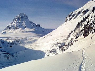
Mount Clements, at left, is a perfect example of a glacial horn, a high rocky pyramidal mountain peak carved by glacier. In the winter, the best way to traverse Glacier National Park is via cross-country skis or snowshoes.
Whatever you do, don't forget to take a close-up view of some of the outcrops as you hike or ski along the trails. Glacier National Park's sedimentary rocks are some of the oldest in the world that still show characteristics of the original deposition, such as ripple marks, mud cracks and raindrop impressions. And then of course, there are the textbook examples of a glacially carved landscape — horns, cirques, arêtes, hanging valleys and moraines — all that remain of several million years of glacial formation and retreat.
Reynolds Mountain is a good example of a horn, a high rocky pyramidal mountain
peak often formed when glaciers carve out three sides of a mountain. Nearby
Mount Clements, another horn, has a big pile of glacial debris at its foot,
called a moraine. A good example of an arête, a thin ridge formed when
glaciers carve out two sides of a mountain, can be found a bit to the north
at Garden Wall.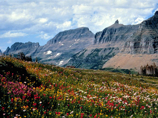
Today's glaciers are a bit harder to find, but one that you can hike to is Grinnell Glacier. The Grinnell Glacier Trail leads you high up a mountain past beautiful milky blue glacial lakes to the shore of Upper Lake Grinnell, from which you can see the retreating Grinnell Glacier.
Garden Wall, at left, is an example of an arête, a long, thin ridge formed when glaciers carve out two parallel sides of a mountain. In the summertime, the area is filled with alpine wildflowers.
Getting to Glacier National Park is easy if you're on a road trip, but not so easy otherwise. The nearest airport is about 20 miles away, and you have to rent a car to get to the park. Amtrak is also a great bet, as they run trains right to the edge of the park and into Whitefish, Mont., the "major" town in the area, from which you can find transportation to Big Mountain Resort or to the park.
Housing options are somewhat limited in number, but not in variety. Within
Glacier National Park itself, many chalets and cabins are scattered about, and
a major hotel operates near Many Glacier (a beautiful area noted for its water
activities). Note, however, that all the cabins and housing within the park
are closed during the winter months. There are also lots of campgrounds and
the park offers permits for backcountry camping year-round. You can also stay
in Whitefish or at Big Mountain, a four-season resort.
Whatever time of year you visit, be prepared for the rustic nature of the park.
Hazards throughout the park include landslides and debris flows, rockfalls from
freeze-thaw activity, and avalanches, not to mention the wildlife — grizzly
bears, moose, mountain lions, elk and more.
Megan Sever
Links:
Glacier
National Park (National Park Service)
Waterton-Glacier
International Peace Park
Hiking
guide to Glacier National Park
Big
Mountain Resort
Whitefish,
Mont., Web site
 |
Geotimes Home | AGI Home | Information Services | Geoscience Education | Public Policy | Programs | Publications | Careers |