Geotimes
Untitled Document

Profiles:
News
about people from AGI and its 43 member societies
Archive of past
Society Page/Profiles stories by date
George H. Billingsley: Mapping
the Grand Canyon
 George H. Billingsley
has had a life-long obsession with the Grand Canyon. “I’ve been working
in the Grand Canyon for 36 years,” Billingsley says, spending up to six months
a year in the field, alone or with colleagues, to create geologic maps that are
as accurate as possible. While with the U.S. Geological Survey (USGS), Billingsley
has published 70 maps of the region, and his love of the landscape keeps him going
back to the field, as he tries to finish mapping the last few corners of the region.
“Just because the Grand Canyon has been mapped does not mean it’s all
done,” he says.
George H. Billingsley
has had a life-long obsession with the Grand Canyon. “I’ve been working
in the Grand Canyon for 36 years,” Billingsley says, spending up to six months
a year in the field, alone or with colleagues, to create geologic maps that are
as accurate as possible. While with the U.S. Geological Survey (USGS), Billingsley
has published 70 maps of the region, and his love of the landscape keeps him going
back to the field, as he tries to finish mapping the last few corners of the region.
“Just because the Grand Canyon has been mapped does not mean it’s all
done,” he says.
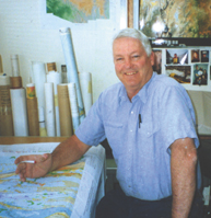
George Billingsley, who has spent his career
in the Grand Canyon, was awarded the Dibblee Medal last fall for his contributions
to mapping. Courtesy of George Billingsley.
His passion for the outdoors and the Southwest started when he was a child on
his parents’ ranch in central Arizona. “I was wondering, ‘how the
mountains were made, why are there so many different rocks there?’ I was
just curious,” Billingsley says. After discovering that the answers came
easily to him, he later pursued geology at Northern Arizona University, where
he earned a master’s degree. “My mom and dad are the ones who pushed
me through [college]; otherwise, I would have stuck with the ranch.”
He pursued mapping in the Colorado Plateau. “You can see the rocks, [and]
by tracing them out, you can see the changes that took place,” with a rare
3-D perspective unavailable in the “jungles” of the eastern United States,
Billingsley says. “There is so much work to be done in the Grand Canyon,
as far as the geology goes, [and] even mapping more details — I have not
been everywhere.”
For this reason, Billingsley considers his maps to be an unfinished tool. He wants
students to “apply their knowledge” to find new pieces: “They might
be surprised that their ideas have not been thought of before,” he says.
That’s a lesson Billingsley probably learned several times in his career,
says Peter Huntoon, a now-retired structural geologist who taught at the University
of Wyoming and the University of Nevada at Las Vegas.
“He and I kind of grew up together in the Grand Canyon,” Huntoon says,
forging a friendship and working relationship in the region’s 100-degree
heat — a trial to the fair-skinned, red-haired Billingsley, who now says
he prefers to work in the field during the cooler parts of the year. The two met
through William Breed, a curator at the Museum of Northern Arizona and later a
co-worker, who suggested Billingsley as a field assistant for Huntoon’s master’s
work in the Grand Canyon in the 1960s.
Billingsley remapped part of that region again for the USGS, and years later,
while mapping on the Colorado Plateau for the Bureau of Indian Affairs, “we
found that there were dramatic improvements in what we were able to tease out
of the rocks,” Huntoon says. He calls the experience “humbling.”
Billingsley says that he starts with what’s published in the literature to
understand what has been done before in a region, but he cannot map without aerial
photos. They collected a library of thousands of aerial photographs for the Grand
Canyon, Huntoon says, and Billingsley “could see things in aerial photos
that a lot of people couldn’t see on the ground.”
Combining the aerial component with on-the-ground mapping is “as accurate
as you can get,” Billingsley says. Billingsley has been dropped off by helicopter
to explore by foot, reaching some canyons that probably were untouched for decades
— though ancient Native American ruins testified to previous human visits,
he says.
One such spot is Surprise Canyon, which Billingsley chose as the name of a formation
he discovered in the 1970s. While working with Edwin D. McKee, a geologist who
is considered an icon of Grand Canyon geology, Billingsley first saw the large
lens-shaped deposits. “He could follow them from butte to butte,” Huntoon
says, in the aerial images and in the field, and ended up identifying a gently
sloping river system that drained the top of karst deposits in the region. Billingsley
published some “landmark” papers, Huntoon says, filling in a 15-million-year
gap in the Grand Canyon’s history because of his keen observation skills
and his “dogged determination.”
Billingsley also explored the region by boat — spending about a decade as
a professional river runner on the Colorado River, while based as a geologist
at the Museum of Northern Arizona. River guiding allowed him to field check observations
made in the off-season, and he became one of the more popular guides, Huntoon
says. His wife Susan, whom he met at Northern Arizona University, also ran the
river as a guide. And one of his children is also now a river guide.
For his career as an “exceptional” mapping geologist and his contributions
as the Grand Canyon’s mapper, Billingsley received the Dibblee Medal, named
for Thomas Wilson Dibblee Jr. (see In Memoriam) last
October. Billingsley continues to work on mapping the Navajo reservation —
an area the size of West Virginia — and several other corners of the Grand
Canyon. Billingsley expects his latest, though not final, addition to Grand Canyon
maps to be ready soon.
Naomi Lubick
Links:
"In Memoriam:
Thomas Wilson Dibblee Jr.," Geotimes, February 2005
Grand
Canyon National Park
Some USGS
maps of the Grand Canyon by George Billingsley
Back to top
Untitled Document
