
 "The
heart of the world beats under the three hills of Boston," wrote poet Oliver
Wendell Holmes around 1860. Above those hills is one of America's most revered
historical cities, and below them are rocks that span more than half a billion
years of Earth's history.
"The
heart of the world beats under the three hills of Boston," wrote poet Oliver
Wendell Holmes around 1860. Above those hills is one of America's most revered
historical cities, and below them are rocks that span more than half a billion
years of Earth's history.
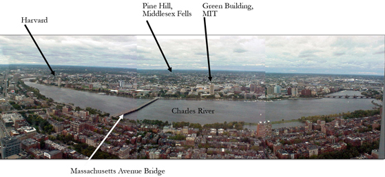
To experience Boston's geology, first get away from the rocks. Go to the middle
of the city, where every rock is paved over, and take the elevator to the 52nd
floor of the Prudential Building. There, four walls of
glass show you the entire Boston region.
The view from the top of Boston's Prudential
Building will give you more than just a cultural history of the city: You can
also see the geological remnants of glaciers, colliding continents and exploding
volcanoes. At the Middlesex Fells Reservation, for example,
visitors can hike or mountain bike among 630-million-year-old volcanic rocks.
All images by Selby Cull.
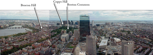
Podiums and exhibits in the viewing area highlight landmarks of the city's rich
history and culture: the gold-plated capitol dome atop Beacon Hill, where the
Puritan group led by John Winthrop settled in 1630; King's Chapel with the grave
of William Dawes, a patriot who rode with Paul Revere on his "midnight
ride"; and Bunker Hill, where a famed battle occurred between the colonists
and the British on June 17, 1775.
What the exhibits won't tell you is that the Puritans settled at the base of Beacon Hill because it is made of stratified sand from a glacial outwash channel. The layered deposits allow groundwater to flow and pool at the base, where the settlers could collect it for drinking water. King's Chapel is built of 450-million-year-old Quincy Granite, which formed when an island the size of Japan collided with the island that carried Boston-to-be, long before it was part of North America. Bunker Hill is a drumlin: a streamlined hill of compacted glacial debris, shaped by a retreating glacier.
 From
the Prudential Building, most of what you see below you is glacial debris. The
Wisconsin Ice Sheet, the last glacier to blanket New England, retreated about
16,000 years ago, leaving in its wake boulders and gravel it had carried down
from the North, and forming Cape Cod and the islands of Martha's Vineyard and
Nantucket. Around Boston, the glacier left dozens of drumlins and "kettles"
(bowl-shaped hollows created when glaciers melt), which form most of the ponds
of the city's "Emerald Necklace," one of the
oldest series of parks and parkways in the United States that are worth a visit
unto themselves.
From
the Prudential Building, most of what you see below you is glacial debris. The
Wisconsin Ice Sheet, the last glacier to blanket New England, retreated about
16,000 years ago, leaving in its wake boulders and gravel it had carried down
from the North, and forming Cape Cod and the islands of Martha's Vineyard and
Nantucket. Around Boston, the glacier left dozens of drumlins and "kettles"
(bowl-shaped hollows created when glaciers melt), which form most of the ponds
of the city's "Emerald Necklace," one of the
oldest series of parks and parkways in the United States that are worth a visit
unto themselves.
From the Prudential Building, you can
see Beacon Hill, where the Puritans settled in the 17th century. Beacon Hill
— the remains of a glacial outwash channel — provided a water source
for the early European settlers through its layered deposits.
But Boston's geology is much deeper and richer than the sculpted mounds of glacial debris that dominate its topography. It is worth driving a bit to visit some of the oldest rocks in the Boston area. First up would be the 630-million-year-old Dedham Granodiorite at the Middlesex Fells Reservation.
You can take the subway or a bus, but it's far easier to grab your car and head north on Interstate 93, about 10 kilometers (6 miles) to the Middlesex Fells Reservation — to hills that are anything but glacial. The reservation, comprising 2,060 acres of wetlands and oak forests, sits on 630-million-year-old granodiorite (volcanic rock) with a large 200-million-year-old basaltic dike. At the reservation, visitors can hike several trails, mountain bike down the steep granite hills or take a boat out on Spot Pond, another kettle hole left by the retreating ice sheet. The Pine Hill trail is an easy starter trail, with views of the ancient rocks, as well as a breathtaking view of Boston.
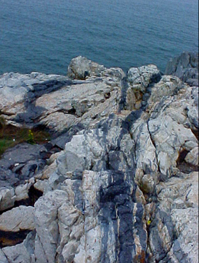 Other
local parks offer further glimpses into the deep past, if you have the time
and inclination. Sixteen kilometers up the coast from the Fells is Castle Rock
in Marblehead Neck, a favorite field trip of geology classes and rock climbers
because of its interesting "swirled" texture. This 600-million-year-old
volcanic rock is all that's left of the explosive volcanoes that once dominated
the Boston area, before they eroded away to nothing.
Other
local parks offer further glimpses into the deep past, if you have the time
and inclination. Sixteen kilometers up the coast from the Fells is Castle Rock
in Marblehead Neck, a favorite field trip of geology classes and rock climbers
because of its interesting "swirled" texture. This 600-million-year-old
volcanic rock is all that's left of the explosive volcanoes that once dominated
the Boston area, before they eroded away to nothing.
A short jaunt up the coast from Boston is Castle Rock in Marblehead Neck, where the "swirling" rocks provide a history lesson on 600-million-year-old volcanoes to rock climbers and geology students alike.
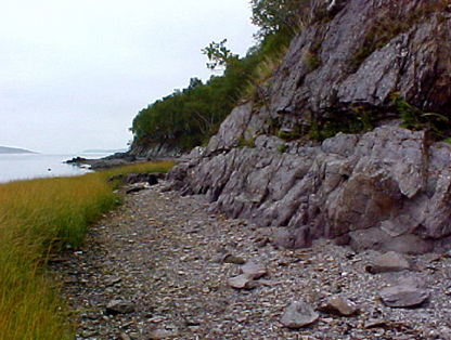
Just south of downtown Boston, near the town of Quincy, Squaw Rock Park offers
a look at some 570-million-year-old rocks, which some researchers think were
deposited during the "snowball Earth" ice age at the end of the Proterozoic.
These ancient sedimentary rocks can be found along the park's small northern
beach, which also offers a beautiful view of Boston Harbor and the Boston skyline.
 Quincy
itself has a fascinating geologic history, as a town made famous by its quarrying
industry. During the 19th and early 20th centuries, the 450-million-year-old
Quincy Granite was such a popular building material that the quarry owners built
America's first railroad to transport the granite to New England cities. The
railroad is no longer in use, but you can find the old start of the tracks at
the end of Mullin Avenue. And although the quarries are now all closed, you
can still find excellent outcrops of the granite along Route 53 and Route 3A.
Quincy
itself has a fascinating geologic history, as a town made famous by its quarrying
industry. During the 19th and early 20th centuries, the 450-million-year-old
Quincy Granite was such a popular building material that the quarry owners built
America's first railroad to transport the granite to New England cities. The
railroad is no longer in use, but you can find the old start of the tracks at
the end of Mullin Avenue. And although the quarries are now all closed, you
can still find excellent outcrops of the granite along Route 53 and Route 3A.
Just south of Boston is Squaw Rock Park,
where visitors can see 570-million-year-old rocks that some researchers think
were deposited during the "snowball Earth" ice age.
Slightly younger but equally interesting rocks can be found at another historic
site, just west of Boston, at Minute Man National Historic
Park, where the famous "shot heard round the world" started the
American Revolution in 1775. There, British soldiers used the 425-million-year-old
Bloody Bluff Fault as a rallying point before beginning their retreat. The fault
is visible on a spectacular outcrop in the park, which is about half an hour
northwest of downtown Boston. While you're there, stop by the visitor's center
to reacquaint yourself with the human history. And if you have the time, walk
or bike the easy 8-kilometer Battle Road Trail through the park.
After your trek through the Boston area's long and varied geologic history, stop in at a pub for a pint and a bowl of clam chowder in the venerable Boston tradition. If the clams ("quahogs" in Boston parlance) are from the harbor, they grew on top of a continental shelf made of 550-million-year-old slate — who can resist? And while you're there, be sure to also try the city's famous baked beans and Boston cream pie.
Getting to Boston is pretty easy, no matter what time of year you visit. Most flights go through Logan Airport, but flying through Providence, R.I., is also an option, as the airport is less than an hour away. Boston is also an easy drive or train ride up the Interstate-95 corridor that runs along the entire East Coast. Most visitors stay in Boston's Back Bay district or Cambridge, across the river, where lodging abounds. Hotel rooms tend to fill up quickly in mid-April for the Boston Marathon, at the end of May for college graduations and near the July 4 holiday, so if you're heading to Boston during those times, book early.
Links:
Prudential
Center Skywalk
Middlesex
Fells Reservation
Minute
Man National Historic Park
City
of Boston parks
Boston
Visitor's Bureau
Travels in Geology
 |
Geotimes Home | AGI Home | Information Services | Geoscience Education | Public Policy | Programs | Publications | Careers |