
|
 Subscribe

Feature
Building Bridges With Icy Challenges
Kathryn Hansen
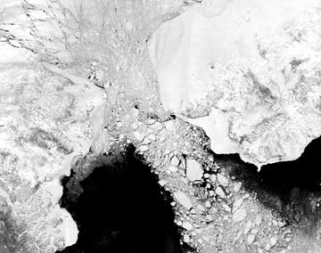 |
| An ice floe pushes through the Bering Strait on its way to the Bering Sea in this May 7, 2000, image capture by NASA's Terra satellite. Image courtesy of George Riggs, NASA GSFC. |
For some people sitting in the office on a Friday afternoon, the weekend can seem miles away. But for people living on or near Cape Prince of Wales, the westernmost point of the mainland United States, Saturday is just kilometers away on the opposite side of the International Date Line, which meanders between Alaska and Russia through the Bering Strait. Should engineers construct a bridge across the strait, Alaska residents could pack up on Friday and drive across the dateline, which also forms the political boundary for Russia, where it would be Saturday. That roadtrip is still likely a long way off, however, according to engineers and geologists, although the idea has been tossed around for more than a century.
The late structural engineer T.Y. Lin was arguably one of the most famous proponents of the idea to bridge the Bering Strait. In 1986, U.S. President Ronald Reagan awarded the National Medal of Science to Lin for his contributions to the field of structural engineering. In return for the medal, Lin made headlines by handing Reagan a 16-page book of plans for a bridge to span the Bering Strait, linking the United States and Russia.
Now, more than 20 years later, political and economic issues keep Lin’s plans firmly on hold. Technical aspects of the project though, according to some engineers and geologists, may be possible — connecting the 90-kilometer-wide strait despite the region’s extreme, icy and earthquake-prone Arctic environment. But for now, the infrequent traveler wishing to cross the dateline and travel from one barren tundra to another will have to rely on floats and wings, not wheels.
Early visions
Lin was not the first to suggest bridging the Bering Strait: Explorer and writer William Gilpin published the idea in his 1859 book The Central Gold Region, in which he envisioned a future worldwide railroad system that would include a rail crossing at the Bering Strait — an idea still advocated today by the Bering Strait Tunnel & Railroad Group. In 1892, Joseph Strauss, in his senior thesis at the University of Cincinnati, who later went on to become chief engineer of San Francisco’s Golden Gate Bridge, suggested spanning the strait with a rail bridge. Still, such ideas remained confined to paper.
The completion of the Alaska Highway in 1943, which spans 2,451 kilometers from Fairbanks, Alaska, to Dawson Creek, British Columbia, replanted the seed of the idea in the heads of some visionaries. At least some infrastructure on the Alaskan side was a step toward making the bridge more viable.
Lin’s efforts, however, perhaps trumped all previous efforts toward bridging the strait. The idea came to him during the international tensions of the Cold War in the late 1950s, after a cruise to Russia. “I finally discovered Russians, Americans, Chinese, they’re all the same,” Lin said in an oral history interview for the University of California, Berkeley. “But why [was] this Cold War going on? I couldn’t understand that. So I made up my mind to contribute toward better understanding between these peoples: I started the Peace Bridge.”
Lin’s idea for the International Peace Bridge (an alternate name he gave to the Bering Strait Bridge), grew from his viewpoint of “let’s build bridges, not bombs,” as a means to connect people and create peace, says Mark Ketchum, the vice president of OPAC Consulting Engineers, Inc., who had worked closely with Lin. “He was somewhat of a visionary in that respect,” Ketchum says.
In addition to being an international peace advocate, Lin was also a renowned structural engineer. To this day, he remains “very famous,” Ketchum says, for his work in revolutionizing a type of concrete that allows bridges to be stronger, more durable and able to better withstand the forces of nature.
The challenges
If building a bridge to cross the approximately 90-kilometer span of the Bering Strait — more than twice as long as today’s longest bridge — isn’t challenging enough, the Bering Strait’s Arctic climate poses a force to be reckoned with. “It’s a very difficult place to build anything, just because of the bad weather,” Ketchum says. Located just south of the Polar Circle, the strait is plagued with ice each year from January to April. Such harsh winters limit the bridge’s construction window.
Once built, the bridge would continue to face weather-related challenges. In winter, sea ice covering the strait usually continues to flow and the strait is “pretty much in turmoil,” says David Scholl, an emeritus geologist with the U.S. Geological Survey’s (USGS) Western Coastal and Marine Geology team. From an engineering standpoint, the bridge would have to withstand significant horizontal forces posed by ice floes and wind, Ketchum says. “Your structure needs to resist the kind of weather that you see in those documentaries about the crab fishermen that go out in their ships up there,” he says.
Springtime melts elsewhere in the United States have previously caused trouble for bridges, as ice breaks into pieces, flows downstream and piles up along a structure in a potentially devastating ice jam. Such jams in spring 2005 damaged several bridges in North Maine Woods, Maine, while another jam on the St. John River in northern Maine stretched for 20 kilometers and piled ice up to 9 meters high, according to NOAA.
The bridge would also have to withstand stress from the region’s frequent and sometimes large-magnitude earthquakes. Just south of the strait is the northern edge of the Pacific Ring of Fire, or “Circum-Pacific belt,” which hosts 90 percent of the world’s earthquakes, according to USGS. At this northern edge, the northward-moving Pacific Plate dives below the North American Plate to form the Aleutian Trench. Such movement over the past 6 million years has resulted in the buildup of most of Alaska’s mountain ranges, as well as the associated system of faults, Scholl says.
Each factor posed by the extreme arctic environment would need to be closely considered by engineers. “But I can’t imagine” that these challenges haven’t been dealt with in many other places in the world, Scholl says.
The solutions
After Alaska became a state in 1959, Lin started to seriously consider moving forward with his dream for the bridge. Toward that effort, he established the now-disbanded Intercontinental Peace Bridge Foundation, which used tax-free money to help engineers arrive at various plans for the bridge and to promote it politically.
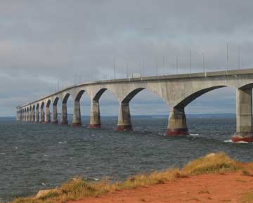 |
| The Confederation Bridge in Canada links the mainland to Prince Edward Island, and is currently the longest bridge built over freezing water. Photograph is courtesy of Quasimime, from Flickr. |
Members of the foundation researched and wrote about numerous versions of the bridge over the years. All versions suggested that the bridge be built from concrete: Whereas steel can become brittle and lead to increased fatigue and cracking in a bridge, concrete used in conjunction with steel would add strength. And in a “challenging environment,” with extreme wet and cold, strength is “even more important than in a benign environment,” Ketchum says.
Today, most bridges are constructed from concrete, as opposed to steel or timber, according to the National Concrete Bridge Council, a transition that started with the introduction of “prestressed” concrete — an advance in the building material for which Lin was famous. Instead of using concrete reinforced with steel rebar, such as that seen in the foundation of a building during its construction, prestressed concrete has been found to add extra strength.
Lin’s innovation centered on the fact that concrete stands up well to compression, but does not generally stand up well to tension and can crack. By precompressing the concrete, which involves taking strong wires and tensioning them across the concrete, the forces that would normally place tension on the bridge now first go toward reducing the compressional force. Overall, the technique adds strength to structures, allowing “longer spans, more slender structures, and in general, better structural performance,” Ketchum says.
The improved structural performance might also help the bridge stand up to earthquakes — a hazard that Scholl does not see as standing in the way of the Bering Strait Bridge. Major earthquakes are known to shake California’s San Francisco Bay Area with some regularity, and yet bridges exist all over the region, he says. Occasionally the bridges do “come down,” he says, noting the 15-meter span of the San Francisco-Oakland Bay Bridge that collapsed during the magnitude-7.1 Loma Prieta earthquake in 1989 during the baseball World Series.
Since the Loma Prieta earthquake, the California Department of Transportation’s Office of Structures Maintenance has sponsored retrofit research at the University of California at Berkeley and the University of California at San Diego. Retrofits specific to individual bridge sites have included encasing the vertical column supports, or piers, with stronger materials, or enlarging the bridge’s connective hinges to allow for more flexibility. Researchers continue to look for new ways to engineer bridges to mitigate earthquake hazards. But generally, engineering bridges to withstand earthquakes “is an issue that’s well-understood,” Scholl says.
The design
With the best material selected, engineers tackled the issue of how to turn the concrete into a bridge. Hundreds of foundations would be driven into the bedrock, which would anchor the piers, Ketchum says. That part of the project would be “quite doable,” Scholl says, as the bedrock is relatively accessible under only 50 meters of water at its deepest point and covered by only a thin layer of sediment. “From an engineering/geology point of view, there might not be anything exceptionally challenging there,” he says.
The ice, too, is not an insurmountable problem for the bridge’s piers. Each pier would have an aerodynamic shape such that when ice encountered the pier, it would be diverted around the pier instead of piling up and putting a potentially destructive amount of lateral stress on the bridge.
Probably the most recent bridge built to consider “serious ice floe issues,” Ketchum says, is Canada’s Confederation Bridge. Completed in 1997, the 12.9-kilometer-long bridge spans the Abegweit Passage of Northumberland Strait, joining the mainland of Canada at New Brunswick to Prince Edward Island. The bridge is currently the longest bridge built over water that freezes: The strait freezes over each year from December until about April.
To prevent ice from piling up, engineers designed a conical ice shield for each pier that lifts up ice floes such that their own weights cause them to break up and flow around each pier. The Bering Strait Bridge would employ a similar design, according to some proposals.
Whether the design challenges posed to the Bering Strait Bridge stem from earthquakes or extreme weather, “there are precedents for these all over the world,” Ketchum says.
As for the rest of the bridge’s proposed design, the piers in turn would support a large, hollow concrete beam with a rectangular cross section (called a concrete box girder) that would house a system of pipelines to transport oil and natural gas, according to some proposals, Ketchum says. On top of that box girder would be a rail transportation component, on top of which engineers proposed a highway for cars. “I think in general the technology is there,” Ketchum says. “We’re not talking about sending people to Mars; we’re talking about the application of today’s engineering technology and materials.”
A question of viability
The question now seems less about whether a bridge can be built in the extreme environment of the Bering Strait and more a question of if it should be built. Many of Alaska’s bridges have been under the watchful eye of federal taxpayers, such as the proposed Gravina Island Bridge. This bridge, dubbed in media reports as the “bridge to nowhere,” has spurred controversy since President Bush signed in 2005 the Safe, Accountable, Flexible, Efficient Transportation Equity Act: A Legacy for Users, which included $223 million for a bridge to link Gravina Island — the site of Ketchikan International Airport and developable land — to Ketchikan, Alaska, which is now a short ferry ride away.
Lin suspected, however, that the Bering Strait Bridge might be most economically viable because of its pipeline component, housed in the cement box girder below the bridge’s railway level. Lin had contact with oil companies that would want the bridge’s pipelines to one day transport oil and gas from Siberia to California, he said in his oral history interview. “The bridge’s reason for existence was political — to make peace — and now it becomes economic,” he said.
Still, to get oil and gas from Siberia to U.S. markets would require that additional infrastructure be built up on each side, including additional pipelines, roads and industry, which Lin said could cost two to four times as much as his estimated $20 billion for the bridge. Also, new treaties and political agreements would have to be conceived. “You can’t just build the link from shore to shore and say you’re done,” Ketchum says. Scholl agrees that before the bridge can be built, someone would need to see its benefit, “and I think a large part of the benefit comes from oil transport from land from Russia, rather than by ship from the Middle East,” he says.
Scholl also estimates a $20 billion price for the project, noting that the price would likely inflate over the multiple decades that the project would take to come to fruition. “If we had to budget it today, and recognizing the realities of schedules and so forth, where do you come up with $40 or $50 billion?” Ketchum asks.
Should engineers move beyond the paper plans and attempt to build the structure, however, the project would likely face considerable opposition from some groups. Resistance to the idea from an oil transportation standpoint might come from those who run the oil tankers, Ketchum says.
And then there are environmental considerations, which would likely arise in an environmental impact statement, Scholl says. What need for the bridge “is so important it would outweigh the raw beauty of this area and its wilderness characteristics?” he asks, comparing it to the damming of the Colorado River that flooded Lake Powell, and having to weigh the cost of cheap electricity to the loss of the beauty of Glenn Canyon. The potential interruption to the migration of whales through the strait is another possible opposition that could be raised should the project go forward, he says. But arguably, Ketchum says, the risk to the environment from the oil pipeline is much less than putting oil in “floating eggshell” tankers.
While innovative engineering could overcome the challenges posed by the Bering Strait’s geology and extreme climate, it has been the economic, environmental and international politics that have kept Lin’s dream from becoming reality. “A project like this needs a champion — someone to relentlessly push it forward for a long time — that person hasn’t surfaced,” Ketchum says.
“So the bridge is still a dream,” Lin said in the oral history interview, “but just to think of it has helped a lot.”
Hansen is a staff writer for Geotimes.
