
|
 Subscribe

Feature
Rolling Across the Roof of the World
James C. Cobb, Lanmin Wang, Edward W. Woolery, Zhenming Wang, Zhijian Wu
The Qinghai-Tibet Railway: Facts and figures Print Exclusive
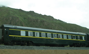 |
| The Qinghai-Tibet Railway runs from Golmud, China, to Lhasa, Tibet, a distance of 1,142 kilometers. Photograph is by James Cobb. |
China made history on July 1, 2006, when the Qinghai-Tibet Railway opened for passenger service. The railway is the highest-elevation passenger train in the world and the first to connect central China with Tibet, providing a controversial but arguably economically significant link between Tibet and the rest of China. Stretching about 1,142 kilometers, the railway runs from Golmud in China’s Qinghai province to Lhasa, Tibet’s capital. Most of its length is above 4,000 meters in elevation, and 50 kilometers is above 5,000 meters.
The railway traverses the spectacular topography of the Tibetan Plateau, cutting across four mountain chains — Kunlun, Fenghuo, Tanggula and Nianqintanggula — where elevations of the trackbed are all above 4,600 meters. It also crosses five major rivers — the Yellow, Yangtse, Mekong (Lancang), Nujiang and Lhasa-Brahmaputra — and passes through the Three Rivers National Natural Protection Region, an area known for its biological diversity, geological and landscape variety, and scenic beauty in southwestern China.
At 4,650 meters elevation on the Tibetan Plateau, with atmospheric pressure and oxygen 45 percent lower than at sea level, an annual average air temperature of 5 degrees below zero Celsius, and extremes including low temperatures of negative 47.8 degrees Celsius and wind speeds above 30 meters per second, this is a harsh climate. Add in solar and ultraviolet radiation 1.5 to 2.5 times what it is at sea level, and not only is preconstruction research and fieldwork a challenge, but so is the construction itself.
In addition, construction of the railway, which began in 2001, had to contend with major geotechnical challenges such as environmental protection, permafrost and geologic hazards, such as steep and unstable slopes, variable hydrologic conditions and seismic activity. But the completion of the railroad across the so-called roof of the world is likely to remain one of the most outstanding geotechnical achievements of the 21st century. And we, a group of researchers from the University of Kentucky (UK) and the Lanzhou Institute of Seismology (LIS), were fortunate to have been a part of this exciting project, at least in small part. Interestingly, none of us had worked at such a high elevation before — 4,700 meters — and adjusting to the conditions wasn’t easy. In the course of a few hours, it was sunny and warm, then rained, sleeted, snowed, and was sunny again. Such are the weather and the working conditions in this remarkable area.
The permafrost problem
The railway crosses the largest area of low-latitude permafrost in the world. (Surprising to some people is that Lhasa, Tibet, lies at 30 degrees north latitude — the same as Houston, Texas.) Stabilizing permafrost was the most pervasive challenge for both construction and maintenance of the railway. Nearly 550 kilometers of the railway is built over permafrost. Protecting the permafrost is key to preventing embankment and roadbed failure from frost heaving and thaw collapse. If the permafrost absorbs thermal energy that is not dissipated, then the permafrost will melt and the roadbed will be damaged.
We were fortunate to meet Professor Luxin Zhang, of Qinghai-Tibet Railway Construction Headquarters in Golmud, who led an international group of more than 100 permafrost scientists and 200 geo-
technical engineers in conducting research and design techniques to preserve the permafrost along the railway. Zhang and his colleagues have worked on Tibetan Plateau permafrost for more than 30 years, collecting tens of thousands of permafrost cores, profiles and data. The harsh and remote conditions of this part of the world made research especially difficult and dangerous, with his team surviving a number of life-threatening situations, from extreme low temperatures and blizzards to wolves, during their preconstruction research on the permafrost.
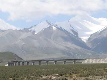 |
| The Qinghai-Tibet Railway boasts more than 450 bridges as it crosses three major mountain chains and five rivers. The railway reaches a maximum elevation of 5,072 meters above sea level. Photograph is by Zhenming Wang. |
Protecting the permafrost along the railway was accomplished using both traditional and less-used approaches. Much of the embankments and roadbeds are protected with “riprap,” which is coarse, angular pieces of rock used to stabilize a surface. The riprap-engineering measures both shield the roadbeds and embankments from solar heating and cool them by convection to maintain a higher thaw depth, which thus protects the permafrost. The larger rock sizes — 10 to 15 centimeters and 40 to 50 centimeters — and the large spaces between rocks are the key to increasing cooling energy and heat exchange under the riprap. The penetration of the cold energy is two to four times greater with the riprap than through normal graded roadbeds.
Other approaches are also used, including bridges, ventilated-pipe roadbed, awning-covered roadbed, and protecting the roadbed with heat pipes. Heat pipes are used on the Qinghai-Tibet Railway for the same reason they are used on the Trans-Alaska Pipeline: to stabilize permafrost by removing heat from the permafrost and dissipating it into the ambient cold air. The advantage of heat pipes is their efficiency in transferring heat. They employ evaporative cooling to transfer thermal energy from one point to another by the evaporation and condensation of a coolant. Heat pipes rely on a temperature difference between the ends of the pipe and cannot lower temperatures at either end beyond the ambient temperature. A total of 30 kilometers of the railway have heat-pipe-protected roadbed, which is particularly effective given the frigid temperatures.
In a slightly different approach, the ventilated-pipe-protected roadbed has an open pipe installed beneath the roadbed through the embankment that cools the ground, as denser cold air flows into the pipes and displaces less dense, warmer air. Any accumulation of heat will be carried away through the pipe, thus maintaining the frozen permafrost.
Finally, nothing is perhaps more effective at keeping surface temperatures cool than shade. Because of the strength of solar radiation in this area, sunshades or awnings were constructed to shade the roadbeds and embankments from solar heating. The awnings also prevent rain and snow from directly impacting the roadbed.
Seismic work
Seismic activity is another important factor in the design of the Qinghai-Tibet Railway, as earthquakes can be both frequent and strong in the Tibetan Plateau. This is where our team in particular came in, as we have been working together to assess seismic hazards and recommend mitigation measures.
On Nov. 14, 2001, a magnitude-8.1 earthquake created a surface rupture 430 kilometers long near the Kunlun Pass. In July 2006, a joint LIS-UK research team conducted field investigations using the shear-wave seismic method where the railway crosses the Kunlun Fault, hoping to characterize the fault — especially its width — close to the train track.
The profile closest to the track showed the fault segment to have spread about 50 meters wide under extensional forces. About 200 meters to the west, the other profile showed the fault to have squeezed together under compression, and is less than 20 meters wide. The shear-wave method worked well in this area imaging a section of permafrost and possible lacustrine and colluvial sediments about 30 meters thick. The railway engineers can use this data to design mitigation measures to safeguard the track from future displacements on the fault triggered by seismic events.
Environmental sensitivity
The Tibetan Plateau has a unique and fragile ecosystem, so 33 animal underpasses were constructed. Additionally, to minimize environmental disturbance during construction, staging areas were planned to minimize surface disturbance and avoid sensitive areas, and were revegetated at the completion of the construction. In order to protect the environment during the life of the railway’s operation, the trains are designed as a closed system to protect the environment it passes through. The train cars are closed, so no waste, litter or discharges are allowed or even possible from the cars. All refuse is contained on board the train for disposal at the stations.
Enjoying the ride
One of the benefits of working on the seismic hazards of the railroad in the summer of 2006 was that we became some of the first passengers on the Qinghai-Tibet Railway. Undoubtedly, the train will become popular for tourists from China, as well as elsewhere. Passengers can begin this train trip in Beijing and end in Lhasa, Tibet — a journey of 4,064 kilometers across scenery unparalleled anywhere in the world.
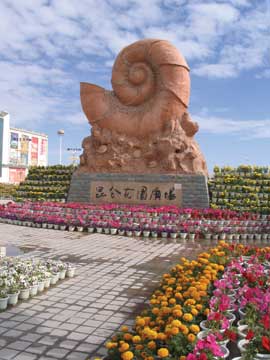 |
| The economy of Golmud, China, is based on the mineral, oil and chemical industries, and it is a transportation hub for the Tibetan Highway and the Qinghai-Tibet Railway. The research team photographed this 7-meter-tall statue of a coiled cephalopod in a new pedestrian mall. The team doesn’t know the story behind the statue, but were impressed by the cephalopod’s elevation from fossil to municipal artwork. Photograph is by James Cobb. |
Snow-capped mountains with impressive glaciers line the railway route, many of which are more than 6,000 meters in elevation. The valleys are wide, filled with streams and rivers and enormous alluvial fans, some of which host large dunes. Many of these valleys contain the sources of important rivers, such as the Yangtse. Even at a distance and traveling at 90 kilometers per hour, we could see large geologic structures such as faults, folds and lithologic changes in the mountains.
Much of the landscape, especially in the north, is treeless and sparsely vegetated. Villages and people are also very scarce. The landscape becomes greener and more populated in the south, toward Lhasa, with flocks of animals, including yak and sheep. We rode the train shortly after its opening, and it was enough of a novelty to attract the attention of people and animals alike.
The train parallels the Tibet Highway for much of the distance from Golmud to Lhasa, and we could see trucks laboring on steep gradients at high altitude to make progress. We also saw Buddhists making their pilgrimage to the holy shrines in Lhasa. At one of the mountain passes we saw a family group with camels and horses escorting a flock of sheep across a highway bridge. It was a dramatic sight to see the ancient modes of transportation sharing the modern bridge with cars and trucks. At the end of the line in Lhasa we were rewarded with sights such as Potala Palace, the traditional home of the Dalai Lama, which was recently named by USA Today as one of the “New Seven Wonders of the World.” It’s worth a visit.
The ride from Golmud to Lhasa takes about 14 hours. The departure from Golmud is timed for early morning, approximately 7:30 a.m., so that passengers will have the maximum daylight hours to see the outstanding scenery. Every passenger on the train is given an oxygen mask to alleviate symptoms of altitude sickness. The oxygen level in each car is monitored as well, and when it is low, passengers are advised over the public address system to plug their masks into the oxygen supply beneath their seats. This is sufficient to increase the oxygen level in the car, so few people actually put on the masks. Cars are also equipped with a digital display that gives continuous updates of elevation, train speed, outside temperature and distance to the next station.
The new rail connection to Tibet is a remarkable geotechnical achievement, encompassing extensive geologic and engineering efforts. The Qinghai-Tibet Railway brings greater access to the Tibetan Plateau — which is good news to geoscientists wanting to see this fantastic and still remote part of the world.
Cobb is the Director of the Kentucky Geological Survey in Lexington, Ky. L. Wang is the Director of the Lanzhou Institute of Seismology in Lanzhou, China. Woolery is a seismologist with the Department of Earth and Environmental Sciences at the University of Kentucky in Lexington. Z. Wang is a seismologist with the Kentucky Geological Survey in Lexington. Wu is with both the Kentucky Geological Survey in Lexington and Lanzhou Institute of Seismology in China. The University of Kentucky and the Lanzhou Institute of Seismology have a scientific exchange program that covers earthquake and seismic hazard research.
The authors would like to thank the staff of the Lanzhou Institute of Seismology, Yongmin Chen, and the graduate students, in particular, for logistical support and help in the field. Our field investigations using SH-wave seismic profiling would not have been possible without their help. We want to thank Professor Luxin Zhang of the Qinghai-Tibet Railway construction headquarters in Golmud for his hospitality and sharing his knowledge of the permafrost. We also want to thank Zhenguang Chang, director of the Earthquake Administration of Golmud, for his help and assistance. Finally, we want to thank Quan Zhu, director of the Tibetan Earthquake Administration, for his assistance and cooperation.

