
|
 Subscribe

News Notes
Oceanography
Eruptive event caught red-handed
 The April mission was simple and routine: Cruise out to a specific location in the eastern Pacific Ocean and retrieve previously deployed seismology equipment from the ocean floor 1,200 meters below. The task proved itself a mission impossible, however, as eight of the 12 seismometers were stuck, engulfed by lava.
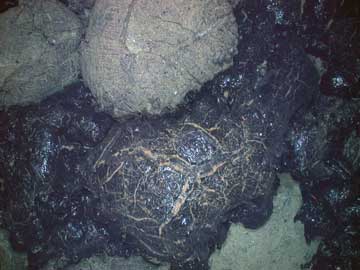
Images of the seafloor show new, dark lava from a recent eruption covering old, light lava from a previous eruption. Data recovered from surviving seismic sensors could help researchers to predict when and where along a ridge spreading events are likely to occur. Image is courtesy of Dan Fornari, WHOI; Jim Cowen, U. of Hawaii; and the TCS06NH science party.
The loss proved to be fortuitous, however, as it marked the first time that seismometers recorded an eruptive event atop the East Pacific Rise — a mid-ocean ridge where the seafloor is quickly spreading apart. The data recovered from the four surviving seismometers, as well as measurements from the surrounding water, could help researchers better understand ocean spreading and forecast eruptive events, a team of researchers reported Nov. 23 in Science Express.
In 1991, researchers discovered lava from a recent eruption at the East Pacific Rise. Since that year, the site has been the focal point for studying the chemistry, biology, physics and geology of mid-ocean ridges. The large human presence and interest in the site makes it the “New York City of the seafloor,” says Maya Tolstoy, a marine geophysicist at the Lamont-Doherty Earth Observatory at Columbia University who led the seismic monitoring team.
Researchers know that, in general, mid-ocean ridges are the site of periodic eruptive events that create new seafloor. At the East Pacific Rise, seismic activity precedes eruptive events that appear to occur on a 15-year cycle. Despite a “close lens of scrutiny” on the East Pacific Rise, however, scientists know little about these eruptive events, such as their typical sizes, extents and how they compare to events at other ocean ridges, says Scott White, a marine geologist at the University of South Carolina, not associated with the study. That could soon change, however.
Upon discovery on April 25 that most of the seismometers were stuck, Donald Forsyth, a geologist at Brown University, and students measured temperatures and the amount of light at various depths in the water. Meanwhile on land, Tolstoy and researchers with the Ridge 2000 program — a long-term endeavor to study mid-ocean ridges and associated tectonics (see Geotimes, December 2002) — set out to organize a subsequent expedition in May to collect further data from the water, visual images from the seafloor, and to date the lava.
The information revealed that lava indeed erupted between summer 2005 and January 2006, and covered an area ranging about 18 kilometers along the ridge, and 1 kilometer away from it. Data from the surviving seismometers suggest that microearthquakes had been building in frequency since 2003, and peaked for one hour on Jan. 22, 2006. That hour is possibly the time at which magma rose to the surface, the researchers wrote.
“When magma comes up through the cracks, it’s loud, as far as seismometers are concerned,” White says. And that information can tell researchers what happened in the ground leading up to an eruption and where the ground actually “ripped open,” he says.
Determining the seismic characteristics that lead up to eruptions could help researchers predict when and where along the trench future events are likely to occur. That’s useful — not from the standpoint of hazard mitigation, as no people are in harm’s way — but as a tool to mobilize resources to study future events, Tolstoy says.
White agrees that improved predictive capability is a major “upside” to the new data. Deploying an instrument and waiting around for 15 years, or half a scientist’s career, is not feasible.
The study is not over, however, and will likely continue for years to come, Tolstoy says. She is currently working on a proposal for an expedition to try and recover the lava-entrenched seismometers, which, if not destroyed by the lava, could possibly contain additional data. Meanwhile, White is planning a trip to map the seafloor at the site, to better constrain the extent of the lava flow.
Kathryn Hansen
Links:
"The Complex World along Mid-Ocean Ridges," Geotimes, December 2002
