
|
 Subscribe

Feature
Finding Ithaca
Megan Sever
 |
I am Odysseus, Laertes' son, world-famed For stratagems: my name has reached the heavens. Bright Ithaca is my home: it has a mountain, Leaf-quivering Neriton, far visible. Around are many islands, close to each other, Doulichion and Same and wooded Zacynthos. Ithaca itself lies low, furthest to sea Towards dusk; the rest, apart, face dawn and sun. Odyssey 9.19-26 |
For millennia, many people have assumed that Homer’s Odyssey was made up — a classic work of fiction. Alternately, others have assumed the epic journey was real — a tale passed down through generations of Greeks. But those believing it was real faced quite a challenge: They did not know where Odysseus’ homeland of Ithaca was.
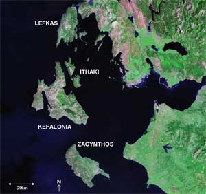
 Still, searchers for the Ithaca of Homer’s description have some clues. They know Ithaca should be an island among a collection of islands somewhere to the west of mainland Greece. And today, the modern island of Ithaki indeed lies in a small collection of islands west of mainland Greece. Ithaki, bearing nearly the same name as Odysseus’ island, thus has long been a contender as ancient Ithaca.
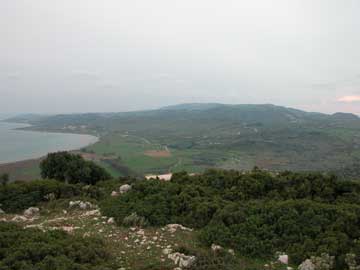
Looking west, toward “dusk,” toward the Paliki Peninsula in western Kefalonia, it is not difficult to imagine that the low-lying area at the head of this gulf could have once been submerged, thus creating two separate islands, as described by Strabo. If that is the case, then Paliki may be ancient Ithaca, as described by Homer in the Odyssey. Photograph is by Robert Bittleston.
Ithaki itself, however, is a poor match for Homer’s description of Ithaca. Ithaki is the farthest east of the Ionian Islands and is not “furthest to sea,” and its coast that faces the open sea faces “dawn and the sun” (east), whereas Ithaca was supposed to face “dusk” (west). Ithaki is also a rugged mountainous island with steep cliffs abutting the sea; it is not low-lying, as Homer described.
Furthermore, Homer described three other islands — Same, Zacynthos and Doulichion — lying close to each other all around Ithaca. While Zacynthos still exists in the Ionians and Same is most likely Kefalonia, Doulichion is unaccounted for, and both islands are westward of Ithaki. So, either Homer was careless with his geographical descriptions, or Ithaki is not Ithaca.
 Today, the question of whether Homer’s Ithaca was a fictional place, or Homer conflated his descriptions and Ithaki is Ithaca, remains up for debate. A third possibility arose in the late 19th century, however, when Heinrich Schliemann, a German businessman and archaeologist, proposed that the legendary city of Troy might be real. Troy, the location of the infamous Trojan War described by Homer in the Iliad, had also long been questioned as a work of fiction. Based on Homer’s description of the city, Schliemann traveled to northwestern Turkey and uncovered what he believed to be the site.
Image is courtesy of NASA.
Subsequent geological and archaeological research has confirmed Schliemann’s location to be the site of ancient Troy, says John Underhill, a geologist at the University of Edinburgh. If Troy is real, and matches Homer’s description almost perfectly (with some leeway given to geological change over the past 3,000 years, such as a coastline shift), people then began to wonder if Ithaca, too, could be real — only disguised by geological processes that reconstructed the layout of the islands.
In 2003, British management consultant Robert Bittlestone began looking in earnest for Homer’s Ithaca. He contacted geologists, including Underhill, to see if geological changes could have been drastic enough to disguise Ithaca. He also contacted classicists, including James Diggle of the University of Cambridge, to look for clues to the real Ithaca within Homer’s epic. And then he set off for the Ionian Islands.
Homer and Strabo
 Around the 8th century B.C., the Greek poet Homer recorded a series of epic tales about a young soldier and king named Odysseus, the Greek hero of the Trojan War, who devised the infamous Trojan Horse that led to the downfall of Troy. After the war, Odysseus set sail for his home, Ithaca, on the other side of the Peloponnesian Peninsula. He lost his way in a storm, however, and spent the next 10 years sailing around the Mediterranean, encountering assorted gods, monsters and calamities along the way.
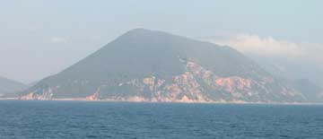
The modern-day island of Ithaki, shown here, is mountainous and rugged, not low-lying as Homer describes. It is a poor match to Homer’s description of Ithaca in the Odyssey, as Robert Bittlestone, James Diggle and John Underhill explore in their 2005 book Odysseus Unbound. Photograph is by Robert Bittlestone.
The Trojan War and Odysseus’ journey home are thought to have occurred during the Bronze Age, sometime around the 13th century B.C., centuries before Homer penned his epic poems, Diggle says. The tales were passed down by word of mouth through the generations, so classicists had long thought that Homer may have just confused his descriptions of Ithaca. Furthermore, although little is actually known about who Homer was, or where or when he lived, it is generally thought that Homer lived in Turkey when he wrote the poems, and there is little evidence that he ever traveled as far as the Ionian Islands to see firsthand the locations he was describing, Diggle says. Once Troy was found to be real, however — as well as other locations described in the Iliad and the Odyssey such as Mycenae, Knossos, Tiryns and Pylos — archaeologists began to wonder where the Ithaca Homer described was.
In the first century B.C., the geographer Strabo penned a 17-volume work called Geography, which includes geographical descriptions of locations around the Mediterranean. Curiously, Strabo wrote that Kefalonia included “an isthmus so low-lying that it is often submerged” by the sea “where the island is narrowest.” This description would be an “independent main clue” that Ithaca could have existed someplace other than Ithaki, Underhill says.
Kefalonia today consists of a main island and a peninsula on the western side of the island, called Paliki, that is joined to the main island by a narrow, relatively flat isthmus with steep sides called the Thinia Valley. Paliki itself is mainly flat and low-lying. If indeed the isthmus had been underwater in Strabo’s time, or in Homer’s time, Paliki would have looked like an island separate from the rest of Kefalonia.
Paliki had been suggested as a possible location for Ithaca “from time to time,” Diggle says, “but it hadn’t ever been taken seriously.” The isthmus rises to about 180 meters above sea level, so even though Strabo had described this isthmus as occasionally submerged, the current geography of the isthmus appears “insurmountable,” Diggle says. Could the isthmus have risen or a shallow marine channel filled in up to 180 meters in 2,100 years? he asks. That’s the question that has to be answered, if researchers are to show that Paliki was an island in the eras of Strabo, Homer or Odysseus. If it were once an island, it indeed would have been low-lying, furthest to sea, and facing west.
Enter Paliki
The Ionian Islands lie in one of the most tectonically active parts of the world, where the African Plate abuts the Eurasian Plate. Kefalonia itself lies at the edge of a fold and thrust system created when the Tethyan Ocean closed during the Cenozoic more than 20 million years ago, and is dissected by a number of major faults, Underhill says. One of those faults, together with sea-level fall during the last ice age, helped create the Thinia Valley and isthmus. Thinia, like much of Kefalonia, is prone to rockfalls and landslides, he says.
Major earthquakes strike the Ionian Islands approximately every 50 years or so — with the last catastrophic one in 1953 — and cause enormous rockfalls and landslides. Additionally, seasonally heavy rains also frequently cause landslides that fill in the valley, Underhill says. The area has also undergone extensive uplift over the last 3,000 years, he says: Wave-cut notches in the rocks indicate that the area has risen at least 6 meters in the last 3,000 years — and locally more than 20 meters in the past 125,000 years. It is clear, Underhill says, that over the last 3,000 years, earthquake and landslide activity have drastically changed Kefalonia and Paliki, and the isthmus that joins the two. But whether it’s enough to account for the isthmus being 180 meters above sea level is tougher to prove, he says.
Geological testing
Over the past few years, Underhill has led an international team of geoscientists who have undertaken a series of geological, geophysical and geomorphological tests, with the support and cooperation of the Greek Institute of Geology and Mineral Exploration, to see if they could scientifically test and thereby either prove or disprove the hypothesized connection between Ithaca and Paliki.
 To find out if the isthmus between Kefalonia and Paliki could have been a marine channel 3,000 years ago, the geologists looked for evidence of “infill” from landslides. Toward that effort, the researchers first mapped the surface geology, which showed that landslides and rockfalls “are dominant processes in the area,” Underhill says. They also ran gravity surveys across the valley to model the subsurface. If the isthmus indeed comprised infill, the subsurface would have to be unconsolidated sediment and rocks, he says — and the gravity surveys showed just that. Furthermore, all along the length of the valley, he says, the “bedrock profile” projects to be at or below sea level, which further supports the infill hypothesis.
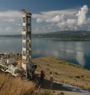
Geologists drilled a borehole 122 meters below the surface on the eastern slope of the southern Thinia Valley to determine the depth to which Holocene rockfall and landslide material occurs and to test the hypothesis that a channel, now buried, once existed there. Photograph is courtesy of John Underhill.
The researchers also charted the history of sea level in the area, to see if sea level could have risen sufficiently to fill the valley 3,000 years ago, “which we can now demonstrate it could,” Underhill says. They shot seismic surveys across the seafloor to see the entire region’s seafloor relief, and more importantly, he says, “to see the subsea topography of the bedrock, to see if a paleo-drainage system exists. And not only does it exist — it leads right to the valley.” The buried channel is “very supportive of the idea that during the last glaciation, 125,000 to 21,000 years ago, sea levels dropped 120 meters below today and cut a river system that lines up perfectly with the Thinia Valley and the southern valley” between Paliki and Kefalonia, he says.
The team has also run ground-penetrating radar (GPR) and resistivity surveys across the surface in strategic areas of Paliki to map the thickness of sediments that accumulated in ancient lakebeds. This is part of a geological landscape assessment that may subsequently help archaeologists to determine if people could have lived there in Odysseus’ day — the late Bronze Age, around 1200 B.C., Underhill says.
So far, Underhill says, much to the geologists’ surprise, none of the geological and geomorphological fieldwork has ruled out that a marine connection could have existed at the time. And the GPR work has indicated the possibility of earlier habitation on Paliki, he says. Until the locations are studied by archaeologists in more detail, however, there’s no telling how old the sites are, he says; they could be much younger than Odysseus’ age.
Still, the hypothesis held up. So last fall, the researchers went back to the isthmus to do more invasive tests to see how deep the bedrock was. At 107 meters above sea level, the team drilled a borehole into the isthmus. The borehole, at 122 meters deep, extended 15 meters below present sea level — and “we didn’t hit any limestone bedrock,” Underhill says. Finding bedrock would have nullified the infill hypothesis, suggesting that the infill from landslides could not account for more than 122 meters of the up to 180 meters of land above the sea that the isthmus reaches. “This was encouraging and was a ‘proof of concept,’” he says.
Once the team completed the drilling, they brought samples back to the lab and have been running tests to date the sediments. They are using marine microfossils in the sediments to try to find the age of the infill of the valley, Underhill says. If the microfossils, such as foraminifera, prove to be within in situ 5,000-year-old or older sediments, that will cast significant doubt upon the infill hypothesis, he says. However, if the microfossils are in reworked 3,000-year-old or younger sediments, then the hypothesis will hold up, he says.
The team is also assessing some of the reworked sediment in the samples for its suitability for radiocarbon dating, hoping to get some organic material, such as trees, that might have been buried during landslides, which could constrain the ages of some of the most significant landslides in the valley, Underhill says. They are also using cosmogenic isotopic analysis and optical thermoluminescence analysis to help constrain and quantify the ages of the rockfalls. This dating isn’t foolproof, as cosmogenic dating isn’t always reliable at such young ages, he recognizes, but if it agrees with the results of other more reliable tests, then it is further evidence supporting the infill hypothesis.
The researchers are also in the process of analyzing some gravity surveys they took in the fall that should help them detect a buried marine channel, if one exists, in the isthmus, Underhill says. “We’re doing a lot of really exciting geoscience right now and getting lots of intriguing results,” he says, all of which will either support or disprove the Paliki hypothesis.
So…is it or isn’t it?
“What has come out of all of this research so far, is that ‘yes,’ it is possible that Paliki could be ancient Ithaca,” says Jerry van Andel, a geologist at the University of Cambridge, who is not involved in the research. “And that’s about as sure as you can get in geology,” he says. A lot of circumstantial evidence supports the hypothesis: The geological examinations so far have shown that it’s possible that 3,000 years ago, Paliki and the rest of Kefalonia were separate islands, he says. But “the clincher,” he says, would be finding the foundations of a palace, or remnants of the kind of high-class pottery and artifacts that go with kingdoms or palaces, which would enable the work to be put into the archaeologists’ hands.
Paliki itself has not been extensively surveyed for archaeological remnants, because Ithaki and the rest of Kefalonia have, until recently, been the archaeologists’ focus, Underhill says. A few Mycenean-aged potsherds, tombs, a sarcophagus and some later polygonal walled buildings have been located at the northern end of the peninsula, he says, so it’s reasonable to expect that more could be found with proper surveys. But that is likely to take several more years, he says. For now, the researchers must work only with the geology, and dating what little evidence they find during geological exploration. They are unlikely to uncover pottery that says, “Odysseus was here,” van Andel says.
Circumstantial evidence is all building up to provide a pretty strong case for Paliki being Homer’s Ithaca, Underhill says. “It’s not proof, but it all fits nicely together,” van Andel agrees. And, Underhill says, just to add more evidence: Other geographical locations described in detail in the Odyssey can be identified on and around Paliki.
And as for the question of what modern-day Ithaki was called in the Bronze Age, if not Ithaca: It was the “missing” island of Doulichion, of course, Underhill says. Historical records have shown that as recently as 330 years ago, Vathy, the capital of Ithaki, was called Dolicha, while Ithaki itself was called Doulichion back in the time of Virgil around 30 B.C.
It appears that geology may help sort the facts from the fiction about Ithaca, just as it helped show that Troy existed.
Sever is managing editor of Geotimes.
Links:
"Even closer to finding Ithaca," Geotimes online, Web Extra, January 9, 2007
Odysseus
Unbound

