
|
 Subscribe

Feature
Geophysics in the Valley of the Kings
Leanne Mallory
New maps key to preserving old tombs
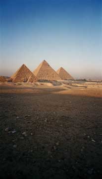 |
| Egypt’s Valley of the Kings is one of the world’s richest archaeological sites, with tombs of pharaohs going back 3,500 years. Recently, geophysicists have begun helping locate hidden tombs beneath the desert. Photograph is by Bruno Girin; courtesy of DHD Multimedia Gallery. |
No other archaeological site in the world evokes such provocative images as Egypt’s Valley of the Kings — the riches of King Tutankhamen, giant pyramids, tombs set into the walls of a desolate valley, and, of course, undiscovered tombs just waiting to be found and excavated. The last royal tomb to be found there, Tutankhamen’s, was discovered by Howard Carter in November 1922. But archaeologists and geologists suspect more are buried beneath the rubble accumulated during several millennia of floods, warfare, excavation and looting. Now, the two fields are coming together to see just what lies beneath the Valley of the Kings.
The archaeological significance of the Valley of the Kings has been known since antiquity. And although many tombs have been forgotten over time, many others have never been lost.
During the Greco-Roman Period, 10 tombs were clear of rubble. And these tombs still remain open to the public. In the 1800’s, searching for tombs in the valley became somewhat systematic. By 1835, John Gardner Wilkinson — a renowned British Egyptologist who was the first to number the tombs — had located 28, in addition to the 10 known. By 1907, almost all the tombs currently known in the valley (64 tombs) had been found. However, many people engaged in the hunt, even at that time, were more akin to treasure seekers and collectors than archaeologists, so many records were less precise than they could have been.
Throughout time, archaeological fieldwork in Egypt has tended to rely on historical records and surface surveys more than anything else. Scientific, and in particular geophysical, methods applied to archaeology are a recent development. Traditionally, Egyptology has relied more on the shovel and trowel than the magnetometer or resistivity meter. Projects and excavations using modern prospecting techniques are a rarity.
The first truly systematic survey of the valley and tombs did not start until the late 1970’s. The Theban Mapping Project (TMP), an academic-led archaeological research organization based at American University in Cairo, Egypt, and currently headed by archaeologist Kent Weeks, was designed to record each tomb and map it as precisely as possible. By this time, however, the entrances to 13 tombs had been lost. Some had been covered over by debris carried down through the wadi — an old ephemeral stream floodplain — during the periodic flash floods the valley is prone to (see sidebar), and others were buried beneath dirt discarded during later excavations.
In 1984, in an effort to find these “lost tombs,” Weeks and the TMP team tried to use electrical resistivity equipment and very-high-frequency electromagnetic tests, which they hoped would reveal spaces within the bedrock that could be tombs. Neither technique worked, however, because Egypt’s climate is too dry for effective resistivity studies, and because many of the tombs had filled in with debris over time.
In 1986, the team returned, this time trying ground penetrating radar (GPR) and seismic refraction, which they hoped would show them variations in soil and sediment conditions, and buried features, such as walls. Again, neither type of survey showed the team what they were looking for due to the debris in the tombs, as well as the fractured nature of the limestone.
The TMP team did have some success during the 1986 field season, however, with another technique: magnetometry, which measures variations in the Earth’s magnetic field that are produced by iron in artifacts or by cavities in the ground. Data are shown as contour line plots, or dot density maps where a higher concentration of dots indicates a greater magnetic anomaly. Computer processing and data filtering help identify subtle anomalies: If researchers are looking for a specific feature, magnetometer studies of known examples of the same type will produce a signature for comparison purposes.
Magnetometry proved to be the most useful technique for locating tombs, although not all magnetic anomalies revealed by this technique are produced by tomb shafts, as any large hollow in the limestone could create an anomaly. To narrow the search area for the missing tombs, the team compared 19th century maps of the valley with the missing tombs indicated on them to the modern geography. The team found two tombs, KV 48 and KV 49, using this technique, and cleared and mapped both of them.
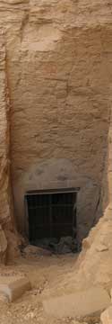 |
| Geophysical tools, such as ground penetrating radar and magnetometers, are helping archaeologists find tomb entrances, such as this one, in the Valley of the Kings. Photograph is by Katarin Parizek, PSU. |
In 1995, Weeks and the TMP team relocated the most famous of the recently rediscovered tombs, that of Ramesses II’s sons (KV 5), by digging a trench rather than using magnetometer data, which had produced confusing results. Later, Weeks noted that the peculiar results from the magnetometer survey of the KV 5 area probably reflected the sprawling layout of this unique tomb, which contains at least 120 chambers. Although a comparison of the magnetometer data with the actual tomb layout has not been done, it is possible that some of the anomalies are the larger rooms and hallways of KV 5.
KV 5 has been under excavation since Weeks rediscovered it. It will probably take many more years to fully clear the tomb of the flood debris that has clogged it, and to deal with some of the engineering problems posed by cracked walls and ceilings. Unfortunately, KV 5 was robbed in antiquity, so very little of the tomb’s furnishings or occupants remain. Still, from a historical perspective, KV 5 has provided insights into tomb design and construction, and answered the question of where Ramesses II buried his many sons.
While TMP’s 1986 GPR survey in the Valley of the Kings was unsuccessful, the geophysical technique has since been utilized further in the valley with more success, providing some provocative and controversial results. As part of their preliminary survey, the Amarna Royal Tombs Project (ARTP) — a team of archaeologists funded by the nonprofit Valley of the Kings Foundation to undertake controlled stratigraphic excavations in the valley to help document and preserve the site — decided to use geophysical techniques to investigate their study area before excavations began.
In the fall of 2000, geophysicist Hirokatsu Watanabe surveyed a portion of the valley in the area assigned to ARTP with GPR. He discovered two anomalies that both appeared as a pattern of radiating arcs. The team interpreted these to represent empty spaces within the limestone bedrock. The empty spaces could be new tombs, or simply voids in the limestone caused by geological processes. ARTP did not immediately release their results to the public, as ARTP’s director, Egyptologist Nicholas Reeves, decided to wait until an appropriate plan of excavation could be put in place.
Unfortunately, fate and politics intervened: The Egyptian government falsely accused Reeves of involvement in the illegal antiquities trade in 2002, and barred him from working in the Valley of the Kings. Reeves was cleared of all the charges against him in 2005, but in the interim, his research was unable to proceed and the Egyptian government reassigned ARTP’s study area to other researchers.
Subsequently, unaware of the radar survey results in ARTP’s study area, a team working on a tomb near the study area located the top of a burial shaft late in the 2005 field season. Archaeologist Otto Schaden decided to delay excavating what appeared to be a new tomb until March 2006. In the meantime, he swore his crew to secrecy until after the official announcement of their discovery had been made.
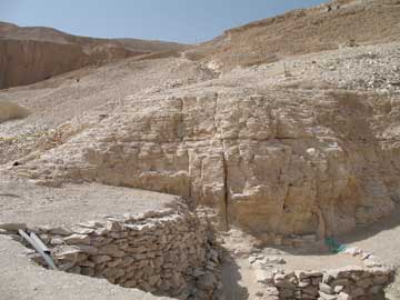 |
| Water follows fractures in the in the sandstone and shale, as seen in the center of this photo, in the Valley of the Kings, leading to deterioration of the fragile tombs. Photograph is by Katarin Parizek, PSU. |
The results of the ARTP GPR survey in relation to this tomb, now numbered KV 63, were made available to Schaden and Zahi Hawass of the Supreme Council of Antiquities in mid-2005, after Schaden’s team had found the tomb while mapping ancient workmen’s huts in the area. KV 63, which was excavated in 2006, did not turn out to be a multi-chambered royal burial tomb, much to the disappointment of all. Instead, archaeologists uncovered a single room off of an entrance shaft. It contained a cache of coffins, jars and mummification materials that were perhaps associated with another tomb nearby.
The second radar anomaly ARTP had mapped in 2000 was revealed to the press in July 2006, before the information was shared with the Egyptian authorities. Reeves dubbed it “KV 64.” His announcement has prompted much controversy and debate, not just over what the anomaly is, but also what approach should be taken to investigate it.
KV 64 is at a greater depth than the single-room KV 63, but has a similar radar profile. Based on a comparison of the GPR data from both sites, Reeves is convinced that it is a tomb with a layout like that of KV 63. Hawass, however, says it may simply be an anomaly in the bedrock, rather than a tomb shaft. With little GPR or other geophysical data to compare it to, exactly what KV 64 represents is the subject of much speculation.
The only way to settle the disagreement over the status of KV 64 — tomb or bedrock cavity — is to excavate, which is the second area of contention. Excavation is an inherently destructive process, and there is no way to go back and re-excavate a site. As the debate continues to rage, there are no immediate plans to begin work at KV 64.
One outcome of the debate over KV 64 and the results of the TMP’s earlier magnetometer studies is that they have drawn the attention of Egyptologists to the possible uses for geophysical prospecting techniques, such as helping to locate and protect sites before development or excavation begins. Long-term site plans could also be put into place where the most threatened areas are excavated first. A danger, however, is that the knowledge of where tombs are located might prompt another “digging” rush. Public interest and economic pressures might push the Egyptian government into allowing excavations that are aimed more at satisfying the curiosity of potential tourists than answering legitimate archaeological questions.
|
New maps key to preserving old tombs The valley receives little rain, yet even a little precipitation in the highlands can lead to flooding. In 1994, during the most recent severe flood, several tombs were inundated with water and debris; others were damaged when water seeped into the underlying shale, causing it to expand. By mapping the valley’s network of rock fractures, a father-daughter team from Pennsylvania State University hopes to help Egyptian authorities protect the tombs. Last year, photographer Katarin Parizek and her geologist father, Richard Parizek, trekked to the Valley of the Kings to map “fracture traces,” surface features indicating areas of fragmented rock beneath the ground. Katarin noticed that tomb passages often follow these structures, likely because builders found the digging easier. But these weak areas are also the pathways water chooses to follow when it rains, making the tombs vulnerable to water damage. Richard has used fracture traces to find groundwater and to site wells since the mid-1960s: Wells drilled along fracture traces have yielded 10 to 100 times more water than those drilled between traces, he says. Richard often brought his whole family along to help him in the field. Katarin absorbed her father’s enthusiasm, as well as a great deal of knowledge about geology. When Katarin toured the Valley of the Kings in 1987, she wasn’t looking for cracks in the rock. But she noticed that the entrances to many tombs were located along fracture traces similar to the ones her father had identified when she was young. “They just kind of popped out at me,” Katarin says. Katarin and Richard began intensively mapping the fracture traces in May 2006, measuring the width and depth of each fractured area, locating where fractures and tomb tunnels meet, and then correlating those meeting points with existing water damage. Katarin presented their data at the annual meeting of the Geological Society of America on Oct. 22, 2006. Water damage is not a new problem in the Valley of the Kings. Egyptologist Patricia Podzorski at the University of Memphis says that there is “clear evidence of flooding in ancient times — enough water that it caused serious damage in the tombs.” Workers have filled cracks and restored broken pillars, but the authorities have yet to address the source of the problem. Katarin compares the valley to a house: “If you don’t fix the roof, next rain you’re going to have more leaks coming through again.” In 2004, Egyptian authorities asked the Theban Mapping Project, an organization that has been mapping the extensive network of tombs in the valley for the past 28 years (see main story), to come up with a management strategy. The master plan lists flooding as a major threat and highlights the urgency of implementing measures to avoid future water damage. That’s where the Parizeks come in. “If you just channel water past the entrance of a tomb and don’t realize there are fracture zones nearby that connect with other tombs below, you could release the floodwater into what seems to be a safe zone only to have it seep down into the cracks,” Katarin says. The team hopes that their comprehensive fracture maps, which they will donate to the Theban Mapping Project, will help planners decide how to divert floodwaters around the tombs to protect these archaeological treasures. Because many tomb entrances are located on fracture traces, the Parizeks also speculate that their maps might help archeologists find new tombs. Podzorski, however, is skeptical. Fracture traces are “so numerous,” she says. “It’s faster to find out where a fracture trace is not than where it is.” |
Mallory is an archaeologist at Okanagan College in British Columbia, who specializes in the Ancient Near East and geoarchaeology. Her research is focused on trade and culture change during the Neolithic and Predynastic periods of Egypt.
