
|
 Subscribe

FEATURE
Tectonic Hypotheses of Human Evolution
M. Royhan Gani and Nahid DS Gani
 M. Royhan Gani and Nahid DS Gani |
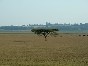
| The present-day vegetation of East Africa is a result of the uplift of the Wall of Africa between 7 million and 2 million years ago. |
Sometime around 7 million years ago, the land in East Africa began to rise in earnest, and life on Earth took a drastic turn. A creature began to evolve into a form that would eventually take over the world.
Exactly how humans originated and evolved is an intrinsic intellectual question. But one thing has become fairly clear: Tectonics was ultimately responsible for the evolution of humankind.
Any discussion of the evolution of life starts with Charles Darwin, and human evolution is no exception. More than a century ago, Darwin saw a link between the African arid savanna and human evolution, an idea that later became popular as the “savanna hypothesis.” However, in his original theory of natural selection, Darwin downplayed the role of the physical environment as a mechanism for evolution, stating instead that natural selection could drive evolutionary changes in the absence of any change in the physical environment or climate.
Over the last century, the impact of geomorphic and climatic change on evolution, particularly human evolution, has gained considerable momentum. Tectonics can be seen as the root cause of Earth’s changing and diverse landscapes, seascapes and their associated climates. The cyclic breakup and reassembly of the supercontinents Rodinia and Pangea can be explained simply by the existence of one or two superplumes (upwellings of abnormally hot rock from the core-mantle boundary) in the mantle. Only two superplumes exist today: one beneath Africa and the other beneath the Pacific. Perhaps, it is this African superplume that was ultimately responsible for driving human evolution in East Africa.
Humanity began in Africa. Genetic and fossil evidence suggest that between 33 million and 22 million years ago hominoids, or apes — a group that includes gibbons, orangutans, African apes (chimpanzees and gorillas) and hominins (ancient and modern humans) — began to evolve. Hominins and African apes (particularly chimps) are closely related. These two lineages split off between 7 million and 4 million years ago, as indicated by DNA and fossil evidence. Most paleoanthropologists agree that this split is the most critical juncture in human evolution, although fossil evidence from this period is rare. Much was happening in Africa at that time, however.
Tearing Apart
The African superplume has been brewing beneath eastern Africa for at least the last 45 million years. The earliest direct surface evidence of the rising hot plume-head is in northeast Africa’s Afar region, as seen by extensive volcanism around 30 million years ago. Consequent weakening of the lithosphere, Earth’s rigid outer layer, by excessive heating and mechanical stretching resulted in rifting in three directions in Ethiopia and in the eventual creation of the Gulf of Aden, the East African Rift and the Red Sea. Rifting causes subsidence that results in rift valleys, and Earth’s crust adjusts to this subsidence by raising rift shoulders on both sides of the valley. In East Africa, uplift of the narrow rift shoulders (tens of kilometers wide) were superimposed on the uplift of wide domes (hundreds of kilometers wide) linked to the plume-head pushing from underneath. The mode and tempo of these uplifts in East Africa were anything but simple.
Over the past 30 million years, the plume has created the East African Rift, a north-south elongated dynamic topography with isolated volcanic peaks such as Mount Kilimanjaro. Rifting in a few places throughout East Africa and propagated both northward and southward, from the Afar region in northern Ethiopia down almost to South Africa. The result was the formation of the “Wall of Africa,” which is about 6,000 kilometers long and 600 kilometers wide, and rises to more than five kilometers high.
This belt is the largest and longest-lived rift in the world, punctuated with freshwater lakes along the rift floors and dramatic relief that runs from 156 meters below sea level — Lake Assal in the Afar Depression, the lowest point in Africa — to 5,895 meters above sea level at Kilimanjaro, the highest point in Africa. Although the Wall of Africa started to form around 30 million years ago, recent studies show that most of the uplift occurred between 7 million and 2 million years ago, just about when hominins split off from African apes, developed bipedalism and evolved bigger brains.
Global Climatic Shifts
Over the last 15 million years, Earth has experienced a net cooling trend superimposed by repeated cooling-and-warming cycles — the so-called Milankovitch cycles related to Earth’s orbital forcing that controls the planet’s variable dose of solar radiation, with periodicities ranging from 20,000 to 100,000 years. The great ice ages, associated with a drier climate, started only between 3 million and 2.5 million years ago.
Because our early ancestors were primarily herbivores, scientists tend to focus heavily on past vegetation changes in East Africa to understand early hominin evolution, as alterations in type and distribution of plants would immediately impact an ape’s food system. Using carbon isotopes, researchers can determine the type of vegetation present in a region at a particular time in the geologic past, such as whether vegetation was wood-dominated or grass-dominated. Recent isotopic studies suggest that an important global shift from wood-dominated to grass-dominated ecosystems that occurred between 8 million and 4 million years ago was likely related to an increase in aridity and, to some extent, fires that cleared out large swaths of forest. No doubt these climate and climate-driven vegetation changes, again at the right time in the geologic past, were critical in hominin evolution. But were these changes that led to a progressive increase of aridity and consequential expansion of open grassland, a phenomenon known as East African aridification, primarily controlled by global (climate) or by local (tectonic) processes?
 M. Royhan Gani and Nahid DS Gani |
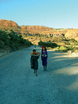
| For survival, these Ethiopian women walk daily for tens of kilometers on rough terrain to collect water and trade food. Perhaps early hominins developed bipedalism, an energy-saving mechanism for traveling long distances by walking upright, for similar reasons, as their food resources were getting widely separated because of the spreading savanna related to East African aridification. |
Thinking Locally
Léo Laporte and Adrienne Zihlman of the University of California at Santa Cruz were the pioneers in linking East African aridification to local tectonics. In 1983, they argued that African uplift and rifting threw the eastern part of the continent into a rain shadow, causing a spread of the savanna and the end of the rainforests that had dominated the landscape. Many subsequent studies have argued essentially the same thing. So far, probably the most convincing case was made by Pierre Sepulchre of the Laboratoire des Sciences du Climat et de l’Environnement Gif-sur-Yvette in France and his team in a recent atmospheric and vegetation modeling study. They found that reduction of East African present-day topography by just one kilometer would permit moist air to circulate across the region, increasing rainfall. The currently dry and grass-dominated landscape would thus transform into one of tree-dominated vegetation. If this rain shadow hypothesis is correct, the uplift history of the Wall of Africa is crucial in assessing East African aridification, and thus human evolutionary changes.
Again, the East African Rift uplift occurred sometime over the past 30 million years, with likely the most uplift occurring sometime after 7 million years ago. New research on the Ethiopian Plateau — perhaps the most prominent part of the wall and next to a significant hominin fossil site, the Afar Rift Valley — suggests that the plateau itself uplifted right in that time period. Analyzing how fast the Blue Nile carved a spectacularly deep canyon on the plateau, a true rival of North America's Grand Canyon, Nahid Gani and her team found that the Ethiopian Plateau uplifted more than a kilometer between 6 million and 3 million years ago.
Other studies have shown a similar trend elsewhere in the rift valley: The majority of the uplift of the Kenya rift-flank, currently rising to 3.4 kilometers high and constituting the central part of the Wall of Africa, occurred between 7 million and 2 million years ago. The Tanganyika and Malawi rift-shoulders, which reach 5.1 kilometers high and comprise the western branch of the wall, were mainly uplifted between 5 million and 2 million years ago. And the Karoo Plateau in South Africa, the southernmost extension of the wall, which currently rises to 3.4 kilometers high, was massively elevated during the past 5 million years. Clearly, the Wall of Africa grew to be a prominent elevated feature over the last 7 million years, thereby playing a primary role in East African aridification by wringing moisture out of monsoonal air moving across the region.
But, the uniqueness of the Wall of Africa is not so much that it is narrow and elevated, but rather that it is spatially variable with contrasting topography. The wall is breached in several places, such as the Turkana Depression, which has an average elevation of only 500 meters and sits between the Ethiopian Plateau in the north and the Kenya Dome in the south. Various rift-flanks and plateaus, in addition to isolated topographic features like volcanoes, likely reached threshold elevations at various times between 7 million and 2 million years ago, resulting in an overall aridification of the region that likely varied somewhat from place to place and from time to time. This view is supported by the finding that the expansion of grasses in East Africa was asynchronous and spatially heterogeneous over this time window, a finding that also goes in favor of local tectonic controls, rather than a global change, for the expansion of grass-dominated vegetation.
Hominin Cradle
Although fossils of hominoids, from which hominins evolved, are widely found in Africa and Eurasia, all of the early — greater than 3 million years old — known hominin fossil sites are located along the narrow belt of the East African Rift. The only exceptions are the oldest (6-million- to 7-million-year-old) “hominin” bones of Sahelanthropus tchadensis found farther west in Chad that, some argue, could be the common ancestor of humans and chimpanzees, rather than hominins.
Clearly, the physiography of East Africa drastically changed during the period when the first hominins evolved — from a near-flat forestland to a landscape with plateaus, volcanoes, mountains, deep rift valleys, freshwater lakes and vegetation patchwork ranging from closed woodland to desert grassland. But, what significance does this change bear on hominin evolution? To address this question, we must first understand what defines a hominin, or for that matter, a human. Paleoanthropologists agree that at least four major characteristics separate the hominins from the hominoids: changes in dentition (the development and shape of teeth), elaboration of culture, increase in brain size and bipedalism.
 M. Royhan Gani and Nahid DS Gani |
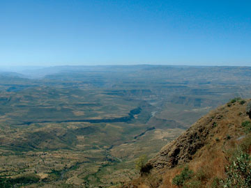
| The Blue Nile carved a spectacular 1.6-kilometer-deep canyon, a true rival of the Grand Canyon of North America. By studying when and how fast the river cut down into the plateau, we now know that the plateau rose more than a kilometer between 6 million and 3 million years ago. |
Not all of these traits are informative at this period of hominin evolution, however. Dental changes are often too complex to track successfully, elaboration of culture can be too subjective, and bigger brains appeared late in the game, around 2 million years ago. Thus we are left with bipedalism. Fossil evidence suggests that bipedalism developed between 7 million and 4 million years ago, which was also the time when hominins split off from the knuckle-walking African apes. Most scientists think that being able to walk upright on two legs is the defining hominin characteristic, and, perhaps, its development is the single most important event in human evolution.
Walking Tall
At least a dozen different hypotheses have been proposed to explain the evolutionary reasons for developing bipedalism. Perhaps the simplest and hence scientifically most reasonable explanation was offered by Peter Rodman and Henry McHenry of the University of California at Davis. They argued that as hominoid food resources became thinly dispersed due to the ever-expanding savanna, bipedalism evolved as a more energy-efficient way to travel between food resources that were becoming increasingly farther away from each other. And the reduction of tree cover is linked with overall aridification of East Africa related to the overall massive uplift of the Wall of Africa. Aridification particularly intensified after 6 million years ago, coinciding with the evolution of bipedalism.
The landscapes where early hominins evolved were not all deserts, however. Analyses of some hominin fossil sites suggest that these areas were isolated freshwater ponds surrounded by open forests, a place where hominins could return after a prolonged food search. Even the anatomy of some hominin bones, for example, the gorilla-like shoulder blade and chimp-like curved fingers of the 3.3-million-year-old Dikika baby (Australopithecus afarensis), investigated by Zeresenay Alemseged at the Max-Planck Institute for Evolutionary Anthropology in Germany and his team, suggests that some early hominins were not fully bipedal, instead spending some part of their time still climbing trees. And interestingly, computer simulations show that a hominin could perform up to 40 percent of its daily activities in trees and still benefit from being bipedal.
The asynchronous uplift and subsidence of the East African Rift resulted in a distinctly complex topography that was markedly variable both aerially, at a length-scale ranging from one kilometer to 1,000 kilometers, and temporally, at a time-scale ranging from 100 years to a few million years. Freshwater lakes within rift valleys were repeatedly created and destroyed by continuous morpho-tectonic adjustments of drainage divides. These variable, tectonics-driven environmental stresses are likely responsible — by thinning out food resources in a controlled way — for forcing hominins to branch off from the hominoids and develop energy-saving upright walking. Such stresses could also be responsible, at a later stage, for hominins developing a bigger brain — as a way to cope with these extremely variable and challenging landscapes. Perhaps, this topographic complexity even provided bipedal, omnivorous hominins with a tactical advantage, enabling them to hunt and hide in a high-relief terrain, as recently argued by Geoffrey King of the Laboratoire Tectonique, Institut de Physique du Globe Paris in France and Geoff Bailey of the University of York in the United Kingdom.
In the quest to better understand human origins, researchers have come a long way from the traditional research of finding and dating hominin fossils, to investigating the global climate drumbeat and finally to considering the tectonic rocking of local climates. However, we are still at a preliminary stage of untangling local climatic signals from global noises. Future studies directed toward a more precise understanding of the magnitude and timelines of uplift and subsidence of the East African Rift, and toward modeling the topography of the Wall of Africa to determine the role it played in changing the East African complex climate over the last 7 million years, would be certainly useful in answering the tantalizing question of how a hominoid became human.

