| Geotimes Home | Calendar | Classifieds | Subscribe | Advertise |
| Geotimes
Published by the American Geological Institute |
Newsmagazine
of the Earth Sciences
July 2000 |
Fire
New Mexico Winds up to 50 mph whipped a prescribed burn on
May 4 into a raging wildfire that destroyed more than 47,000 acres and
left more than 200 families homeless. In Los Alamos, the fire forced 25,000
people to evacuate. A small army of 1,262 firefighters managed to contain
the fire after a lengthy two-week battle, but 700 remained on guard after
spot fires from wind-blown embers flared up on May 26. More than 1,500
archaeological sites may have been scorched, including delicate sites on
the edge of Santa Clara Pueblo at Santa Clara Canyon. The fire, which the
National Park Service started in an effort to thin brush at Bandelier National
Monument, was expected to continue to smolder, smoke and flare up within
its 143-kilometer confines until New Mexicos summer rainy season, which
started early this month.
|
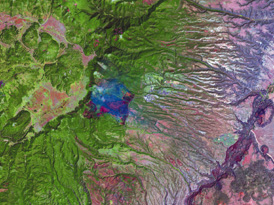
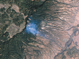
On May 9, from 427 miles in space, Landsat 7 acquired this image of Los Alamos, shown in true color (right) and in visible and infared (left). Images courtesy of Rob Simon, Earth Observatory, NASA/Goddard Space Flight Center. | |
Earthquakes
Indonesia A magnitude-7.5 earthquake devastated Sulawesi and
nearby islands on May 4. At least 46 people died, 254 were injured and
another 30,000 others were left homeless. The quake damaged 80 percent
of the buildings in Banggai. Fire burned dozens of houses and destroyed
a local market in Luwuk. A local tsunami with estimated wave heights of
up to six meters caused much of the damage east of Luwuk and on Peleng.
The temblor originated at 1.41 degrees south latitude and 123.62 degrees
east longitude. It occurred at a depth of 21.7 kilometers below the surface
and had a half-duration time of 16.4 seconds.
Taiwan At least four people were killed after several earthquakes
jolted the island on May 17. The first and most severe quake, measuring
a magnitude of 5.3, struck about 25 miles northeast of the Sun Moon Lake
resort area, about 95 miles south of Taipei. Five more moderate earthquakes
followed near Taichung County. A rockslide triggered by shaking buried
one victim. At the hot springs resort, a construction worker fell to his
death in a ravine when the tremor hit. Twelve people were reported injured
and 39 others stranded after landslides blocked mountain roads. After months
of tension between China and Taiwan, the quakes provoked a rare friendly
response: Chinas Association for Relations Across the Taiwan Straits
the agency that handles Taiwan relations offered its profound condolences,
the state-run Xinhua News Agency said.
Volcanoes
Alaska The Shishaldin Volcano showed an increase of low-frequency
events on May 15, but remained a level green, indicating normal seismicity
and fumarolic activity. In February the level had been raised to yellow
after steam plumes shot 3,000 feet above the crater. The Shishaldin Volcano
is one of the most active volcanoes in the Aleutian arc. It has erupted
at least 29 times since 1775. The cone has a base diameter of approximately
16 kilometers). The most recent eruptive period occurred last year in April
and May.
Ecuador Tungurahua Volcanos crater glowed in early May. Nearly continuous gas and occasional ash emissions erupted throughout the month, teasing scientists and residents of Ba~nos, who anticipated a violent explosion.
Hurricane
Tropical Storm Aletta reached minimum hurricane
strength of 75 mph on May 25, becoming the first hurricane of the 2000
eastern Pacific season. Aletta was centered approximately 355 miles south-southwest
of Acapulco, Mexico.
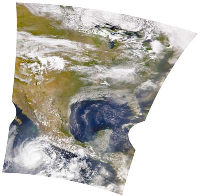 |
Image from: SeaWiFs Project,
NASA/Goddard Space Flight Center, and ORBIMAGE
|
Island
| Solomon Islands After nine years of quiet sleep, the shallow Kavachi seamount erupted, shocking local sea life and an international team of scientists studying sea floor volcanic activity and associated mineral formation in the Bismarck and Solomon seas north of Australia. Kavachi, in the Solomon Island chain of volcanoes, is only 30 kilometers from the boundary of the Indian and Australian tectonic plates. The new island-building volcano is a roughly conical feature rising from a sea floor depth of 1,100 meters. Kavachi is about eight kilometers in diameter at its base and has produced ephemeral islands at least twice in the past century. The team on the Australian Commonwealth Scientific and Industrial Research Organisation research ship Franklin made a comprehensive study of the eruptive activity, as the volcano ejected molten lava up to 70 meters above sea level and mushroomed sulfurous steam plumes to 500 meters. | 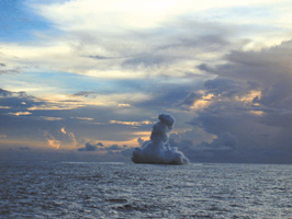
Image from: Australian Commonwealth Scientific and Industrial Research Organisation |
Associate Editor Christina Reed compiles Geophenomena.
 |
Geotimes Home | AGI Home | Information Services | Geoscience Education | Public Policy | Programs | Publications | Careers |