Click
here to pick up where
the print issue left off.
the print issue left off.

|
Click
here to pick up where
the print issue left off. |
 The past
year provided a wealth of exciting data returned by several spacecraft exploring
the solar system.
The past
year provided a wealth of exciting data returned by several spacecraft exploring
the solar system.
In October of 2001, the Mars Odyssey spacecraft joined the successful Mars Global
Surveyor in orbit around Mars. Odyssey carries the first gamma-ray spectrometer
and neutron detectors to map Mars, capable of detecting abundances of a number
of elements in the martian regolith. Initial results show that the regolith
poleward of 60 degrees south contains approximately 50 percent water within
the upper meter, as do some areas in the northern plains of the planet (Boynton
et al., Science online, May 30, 2002; 10.1126/science.1073722; Feldman
et al., Science online, May 30, 2002; 10.1126/science.1073541; Mitrofanov,
et al., Science online, May 30, 2002; 10.1126/ science.1073616). Odyssey
also carries the Thermal Emission Imaging System (THEMIS) instrument, which
will map the entire planet at infrared wavelengths with a resolution of 100
meters per pixel and with visible light images at 18 meters per pixel. THEMIS
is returning the first nighttime thermal images of the surface, which show variations
in the thermal inertia of materials. It is anticipated that the 100-meter-resolution
multispectral data will reveal variations in mineralogy previously obscured
by dust in images of poorer resolution. The result should be a complete mineralogical
map of Mars.
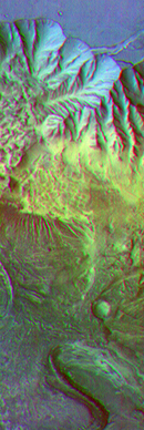
Different mineral composition of the
rocks, sediments and dust on the surface provide a colorful infrared image of
geologic layering on Mars. This image shows a portion of Candor Chasma, a canyon
within the great Valles Marineris system of canyons, at approximately 5 degrees
south latitude, 285 degrees east (75 degrees west) longitude. The area shown
is approximately 30 by 175 kilometers (19 by 110 miles). The image combines
exposures taken by Odyssey’s thermal emission imaging system at three different
wavelengths of infrared light: 6.3 microns, 7.4 microns and 8.7 microns.
NASA/JPL/Arizona State
University
The Mars Global Surveyor (MGS) craft is in the second year of its extended mission
and continues to collect meter-resolution images and topography of the planet.
From July to September 2001, dust storms obscured the majority of the planet
and imaging efforts were concentrated on the South Pole, where the atmosphere
was clear. A comparison of images of the carbon dioxide-rich ice cap showed
very fast sublimation rates of ice over the last two years (Malin et al., Science
v. 294, p. 2146). Topographic measurements showed that similar amounts of ice
sublimated seasonally from the northern cap as well (Smith et al., Science
v. 294, p. 2141). Such high sublimation rates may significantly alter atmospheric
pressures on Mars over hundreds or thousands of years, with consequences for
the stability of liquid water on the surface and the location and erosive power
of winds.
Another study models the amount of liquid water that may be produced by melting
of ground ice in the martian regolith when the planet is at high obliquity (105
year timescale), which results in increased surface temperatures and pressure.
This work suggests that recent gullies on Mars may be relicts from the last
era of high obliquity (Costard et al., ((Science)) v. 295, p. 110). In addition
to studies of martian hydrology, continuing analyses of MGS data improve models
of martian gravity, magnetics, atmosphere and geologic history. Several such
studies are included in the Oct. 25, 2001, issue of the Journal of Geophysical
Research--Planets (JGR-Planets).
Planning continues for selecting sites for the 2003 Mars Exploration Rovers.
A top candidate is an unusual, Texas-sized area of the surface containing grey,
crystalline hematite, which on Earth is often formed by precipitation from hydrothermal
fluids.
The Galileo spacecraft performed its last close flyby of Io in January of this
year, placing the craft on a trajectory to crash into Jupiter in 2003. Io continues
to erupt furiously, and the study of Galileo visible and near-infrared data
over several years reveals that Io's volcanoes erupt in varying styles: steady
and long-lived vs. short-lived, intense eruptions and ultrabasic vs. basic lavas
(evidence for sulfur flows remains ambiguous). The images also lend insight
into the tectonics of ionian mountains and mass wasting. The Dec. 25, 2001,
issue of JGR-Planets contains many of these studies. Analyses continue
on the surface morphology and magnetic fields of the other Galilean moons, each
of which may currently have or at one time had an underground ocean.
A recent study (Schenk, Nature v. 417, p. 419) uses impact craters to
constrain the thickness of the icy crust of Europa to a minimum of 19 kilometers,
which may preclude exchange between the ocean and the surface, and will make
future exploration of the europan ocean more difficult.
![]() On
Sept. 22, 2001, the Deep Space 1 mission passed by the nucleus of the comet
19P/Borrelly, returning visible and infrared data at a 200-meter resolution.
The young, morphologically variable surface contains no evidence of water or
hydrated minerals and has active dust jets (Soderblom et al., Science
v. 296, 1087). A comet is also the target of the Stardust mission, currently
on its way to intersect with comet Wild 2 in 2004, where it will collect particles
in the coma and return them to Earth in 2006. Sample return of solar wind particles
is the goal of the Genesis spacecraft, which was launched in August of 2001
and will return samples in 2004. These missions will significantly improve our
understanding of the chemical and isotopic composition of interstellar dust,
the outer solar system and the solar nebula. The curation and handling of these
samples will also pave the way for other sample return missions, particularly
those planned for Mars.
On
Sept. 22, 2001, the Deep Space 1 mission passed by the nucleus of the comet
19P/Borrelly, returning visible and infrared data at a 200-meter resolution.
The young, morphologically variable surface contains no evidence of water or
hydrated minerals and has active dust jets (Soderblom et al., Science
v. 296, 1087). A comet is also the target of the Stardust mission, currently
on its way to intersect with comet Wild 2 in 2004, where it will collect particles
in the coma and return them to Earth in 2006. Sample return of solar wind particles
is the goal of the Genesis spacecraft, which was launched in August of 2001
and will return samples in 2004. These missions will significantly improve our
understanding of the chemical and isotopic composition of interstellar dust,
the outer solar system and the solar nebula. The curation and handling of these
samples will also pave the way for other sample return missions, particularly
those planned for Mars.
We continue to analyze data from the Moon and Venus and of meteorite chemistry
to improve our knowledge of the context of the solar system. Terrestrial analogs
of martian surfaces were the topic of field trips in the Mojave desert in October
of 2001, sponsored by NASA and the Lunar and Planetary Institute. The planetary
community looks forward to the arrival of the Cassini spacecraft at the Saturn
system in 2004, where it will drop a probe (with cameras and a gas chromatograph/mass
spectrometer) into the atmosphere of Titan. The MESSENGER mission to Mercury
remains on track for launch in 2004 to explore this Moon-like world. It is anticipated
that the Pluto-Kuiper Belt Mission will launch in 2006 to explore what could
be the ninth planet. It looks to be another exciting decade in planetary geosciences
as we test our understanding of geologic processes on other worlds.
Back to index
 |
Geotimes Home | AGI Home | Information Services | Geoscience Education | Public Policy | Programs | Publications | Careers |