 Virginia's
Highlands
Virginia's
Highlands
Many East Coast residents, thoroughly saturated with the lush hardwood forests and rounded peaks of the central and southern Appalachian Mountains, may think they need to make the trip all the way to northern New Hampshire or Vermont to experience alpine landscapes and a rugged, mountainous topography. The Grayson Highlands, in southwestern Virginia, however, offers a closer and no less-scenic opportunity to break the uniformity of the Appalachians and learn about the geologic history of eastern North America.
The Grayson Highlands, with mountain meadows and rocky terrain often ensconced
in thick fog, are reminiscent of the Scottish moors and uplands. An average
elevation of about 5,000 feet and scattered clumps of spruce and fir trees give
the impression of being near the tree-line. The region contains some of Virginia's
highest mountains, including the tallest, Mount Rogers, at 5,729 feet. Wild
ponies wander throughout the area, which is laced with hiking trails.
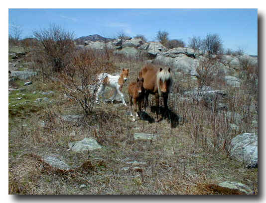
Two herds of free-roaming wild ponies wander among the high country. The ponies shown here are exploring the "Crest Zone." Image courtesy of USDA Forest Service.
Hiking is by far the best way to get a feel for the region's geology, but for those pressed for time, a scenic byway (state Route 58) cuts across the southern section of the highlands. The relatively small Grayson Highlands State Park is located along the byway and has spectacular views out over the highlands. The visitor center offers guided hikes, which provide some information on the natural history and cultural significance of the area. Picnic facilities and campsites are also available.
The real gem of the highlands is the Lewis Fork Wilderness, 10,000 acres of primitive backcountry with more than 400 miles of trails. It contains many of the highest peaks and is shrouded in red spruce and Fraser fir forests at the highest elevations. An area called the "Crest Zone," including Wilburn Ridge, Stone Mountain and Pine Mountain, offers some of the most stunning scenery, with wind-swept rocky ridges and wide-open grassy fields.
 The Grayson Highlands
owes its scenery and elevation to the hard volcanic bedrock. The highlands are
underlain by 750-million-year-old, erosion-resistant rhyolite — a volcanic
rock derived from melted continental crust. In modern occurrences, it is often
associated with continental extension.
The Grayson Highlands
owes its scenery and elevation to the hard volcanic bedrock. The highlands are
underlain by 750-million-year-old, erosion-resistant rhyolite — a volcanic
rock derived from melted continental crust. In modern occurrences, it is often
associated with continental extension.
Geologists have used the presence of rhyolite in the Mount Rogers area to help
make the case for the extension and ultimate rifting of the North American continent
750 to 570 million years ago. That rifting eventually led to the opening of
the Iapetus Ocean, a predecessor of the Atlantic Ocean. The sediments deposited
in the Iapetus Ocean today make up many of the rocks in the Appalachian Mountains.
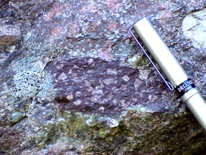
Due to variation in chemical composition,
rhyolites in the Mount Rogers area range in color from dark purple, seen here,
to almost white. Bright pink phenocrysts (large crystals in a fine-grained matrix)
of feldspar stand out against the dark Backgroud. Image courtesy Jon Tso and
Dan Gilliam.
Some of the most accessible rhyolite exposures are on top of Haw Orchard Mountain in Grayson Highlands State Park and on Whitetop Mountain, to the west of the park. Also, some excellent outcrops along the Elk Garden Ridge trail lead toward Mount Rogers. The observant hiker might also notice volcanic tuffs and breccias (angular volcanic fragments embedded in a fine-grained ash matrix) interspersed amongst the massive rhyolites.
When it comes time to rest, visitors can head down to Damascus, a small, quaint mountain town about 10 miles west of Mount Rogers. Damascus bills itself as "Trail Town, U.S.A.," and is regarded as one of the most hiker-friendly locations along the Appalachian National Scenic Trail, which passes through both Damascus and the Grayson Highlands. This quiet, ex-logging town makes it is easy to forget the blistered feet and even easier to let the region's explosive volcanic past fade from the imagination.
Jay
Chapman
Geotimes summer intern
Links:
Grayson Highlands State Park
Mount Rogers National Recreation Area
Mount
Rogers Area Geologic Hisotry
Mount
Rogers Geologic Field Trip Guide
Read more Travels in Geology
 |
Geotimes Home | AGI Home | Information Services | Geoscience Education | Public Policy | Programs | Publications | Careers |