 Geological
mapping provides critical information for protecting drinking water, identifying
resources, designing facilities, dealing with hazards, and understanding earth
history and processes. Only 20 percent of the United States, however, has been
mapped at the scale needed for land-use decisions. Conferences this year, however,
highlighted rapid innovation in this field.
Geological
mapping provides critical information for protecting drinking water, identifying
resources, designing facilities, dealing with hazards, and understanding earth
history and processes. Only 20 percent of the United States, however, has been
mapped at the scale needed for land-use decisions. Conferences this year, however,
highlighted rapid innovation in this field.
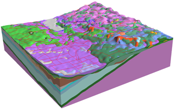
This 3-D geological map of the Winnipeg
region was produced by Manitoba Geological Survey and Geological Survey of Canada.
Courtesy of Harvey Thorleifson.
At the fall meeting of the Geological Society of America (GSA) in Seattle, for example, a poster session on "Geological mapping: key to successful management of water and land resources" attracted 73 abstracts — the largest session at the largest GSA meeting in history. In Poland in November 2003, participants in a NATO-sponsored Advanced Research Workshop highlighted innovative techniques for new mapping. The methods seek to preserve existing data, facilitate technology transfer, and deliver relevant, standardized and customizable geological map information to the widest possible range of users, with information on varying degrees of confidence.
Governments are acknowledging the critical need for geological mapping. On April 28, 2004, the 1992 National Cooperative Geologic Mapping Act, which launched the U.S. Fedmap, Statemap and Edmap programs, was introduced for reauthorization. In Canada, the Cooperative Geological Mapping Strategies produced by the National Geological Surveys Committee focused on mapping needed to preserve competitive advantage in mineral exploration investment. Nongovernmental policy positions, such as the GSA statement on the value of geologic mapping, bolstered these efforts.
Activities have also focused on coordinating information management. In the United States, the National Geologic Map Database has been linked to efforts in Canada, universities and the private sector. The project is using an incremental approach to achieve consensus while making progress on crucial priorities such as terminology development. Concurrently, initiatives such as the International Union of Geological Sciences Commission on the Management and Application of Geoscience Information (CGI), the Canadian Geoscience Knowledge Network and projects such as Geon are crucial mechanisms for development of standards.
Communications programs are also effectively promoting mapping efforts. This year, the American Geological Institute (which publishes Geotimes) published "Meeting challenges with geologic maps," an impressive booklet presenting examples of how geologic maps are helping to delineate ecosystems, protect against hazards and find resources. Also published this year was the superb Britain beneath our feet, a British Geological Survey (BGS) atlas that illustrates the relevance of mapping.
Progress from paper to digital, from plan-view to 3-D, and from static to dynamic
is changing our attitudes on what constitutes a map and how broad the user community
can be. BGS has been particularly active in customizing map products for varying
user groups. In the United States and Canada, a series of 3-D mapping workshops
has demonstrated a paradigm shift as polygons on paper are becoming 3-D solids,
depicting subsurface materials both onshore and offshore, with material properties
quantitatively specified. These developments demonstrate that geological mapping
is steadily progressing, allowing the client base to progressively broaden and
be more effectively served.
Back to index
 |
Geotimes Home | AGI Home | Information Services | Geoscience Education | Public Policy | Programs | Publications | Careers |