
 Of the hundreds
of active volcanoes that currently are rumbling around the world, the United
States and its territories contain 169. An assessment of the risks and hazards
associated with those volcanoes has led U.S. researchers to suggest a plan of
action for avoiding future disasters, including threats to airplanes and populations
living around these features.
Of the hundreds
of active volcanoes that currently are rumbling around the world, the United
States and its territories contain 169. An assessment of the risks and hazards
associated with those volcanoes has led U.S. researchers to suggest a plan of
action for avoiding future disasters, including threats to airplanes and populations
living around these features.
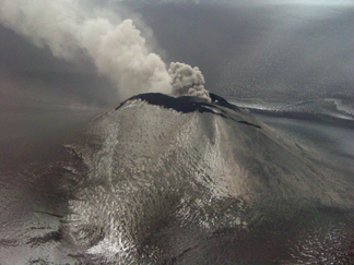
An ash plume drifts from the Veniaminof
volcano, photographed during an observational flight on Jan. 11, 2005. Located
in Alaska’s Aleutian island chain in the northern Pacific, it is one of
many U.S. volcanoes in the path of major airline flights. Courtesy of USGS/K.L.
Wallace.
“The threat itself isn’t the whole story,” says Marianne Guffanti
of the U.S. Geological Survey (USGS), a co-author with two other USGS volcanologists
of the report; it’s also about how well-monitored the volcanoes are. The
research team examined the activity of all U.S. volcanoes and their histories,
determining that the majority of the most threatening volcanoes sit in the Marianas
Islands in the northern Pacific, Alaska’s Aleutian Islands, the Pacific
Northwest and California — and some are watched more closely than others.
For example, California’s Long Valley Caldera has long been rumbling with
earthquakes — indicating movement of magma at depth — and the volcano’s
activity is well-tracked by an intricate network of GPS monitors and seismometers,
all constantly watched by geologists and volcanologists. “The threat is
mitigated by that monitoring,” Guffanti says.
However, volcanoes in the Aleutians or the Commonwealth of the Marianas remain
relatively unwatched, according to the USGS report. These volcanoes sit in the
flight path of commercial and military planes (the air force base at Guam near
the Marianas, for example), and if any of these Pacific volcanoes suddenly ramped
up their activity, the consequences could be dire. Planes that fly through ash
clouds suffer extreme damage at great cost, with possible threats to passengers’
lives (see Geotimes, October 2004).
The USGS report’s authors propose a series of necessary steps, from setting
up monitoring centers that function “24/7” to how to distribute information,
all to be incorporated into a National Volcano Early Warning System, or NVEWS.
Guffanti says that the costs of such measures would amount to $15 million a
year, including monitoring systems for three or four high-threat, under-monitored
volcanoes, in addition to the $25 million such programs already receive annually,
such as the Cascades Volcano Observatory.
“There are just a lot more people living near volcanoes,” as population
densities change globally, says Lee Siebert of the Smithsonian Institution’s
Global Volcanism Program, which provided data for the report but was not involved
in it. But communities differ vastly from place to place. In the Cascades Range,
for example, some large volcanoes lie near large population centers and could
inflict “major” damage even at great distances, from ashfall and lahar
or debris flows. The isolated Aleutian volcanoes, on the other hand, “are
very remote to population centers, and consequently pose very little threat
to people on the ground,” Siebert says, but “because they are situated
along major air traffic routes, they pose a potential threat to passengers.”
The report, Siebert says, is important for prioritizing which volcanoes need
more attention, even though he agrees with the authors that a detailed assessment
would take much more time. “Time is of the essence in a volcanic crisis,”
Siebert says. “Adequate monitoring at U.S. volcanoes would allow forecasting
of potential eruptions that would give scientists and civil authorities a wider
time window to deal with a volcanic crisis.”
“Right now there are only a few of the mountains actually being monitored
to the point that we feel comfortable with,” says George Crawford, manager
for the Earthquake Program of the state of Washington. Mount Rainier, for example,
has an extensive warning system for lahars, which are mudflows that could ensue
from a large landslide or eruption and threaten around 50,000 people (see Geotimes,
April 2004). “If you have 24 hours, 7 days a week coverage, it allows
you to really move quickly.”
Guffanti says that monitoring will help geologists interpret volcanic unrest
that is not a threat as well. “We want people to live in geologically active
areas and neither overreact nor underreact,” she says. “Over-reacting
costs time and peace of mind; underreacting costs lives.”
Naomi Lubick
Links:
"An ashen threat to aviation safety,"
Geotimes, October 2004
"Paths of
Destruction: The Hidden Threat at Mount Rainier," Geotimes, April
2004
NVEWS
report: "An Assessment of Volcanic Threat and Monitoring Capabilities
in the United States: Framework for a National Volcano Early Warning System"
 |
Geotimes Home | AGI Home | Information Services | Geoscience Education | Public Policy | Programs | Publications | Careers |