Geotimes

Untitled Document

Geophenomena
An ashen threat to aviation safety
Volcano refuge ends
An
ashen threat to aviation safety
 Earlier this
year, Bill Rose flew past an ash cloud erupting from Fuego, one of Guatemala’s
several active volcanoes. Although the pilot “knew how to handle it,”
says Rose, a volcanologist at Michigan Tech, and the flight landed smoothly, other
planes have not been so fortunate.
Earlier this
year, Bill Rose flew past an ash cloud erupting from Fuego, one of Guatemala’s
several active volcanoes. Although the pilot “knew how to handle it,”
says Rose, a volcanologist at Michigan Tech, and the flight landed smoothly, other
planes have not been so fortunate.
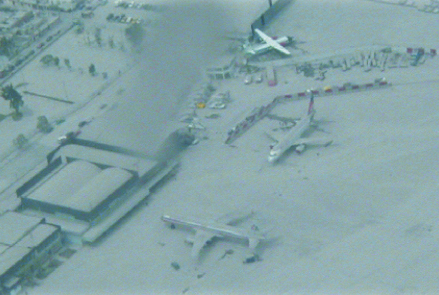
In 1999, Guagua Pichincha volcano in Ecuador explosively erupted, covering the
nearby Quinto airport with ash. Roughly 300 flights pass over active Ecuadorian
volcanoes daily, carrying more than 10,000 passengers and millions of dollars
in cargo. Now, concerned parties are getting together to help limit the volcanic
risk to aviation. Image courtesy of Hugo Yepes, Instituto Geofisico-EPN.
A KLM flight from Amsterdam to Anchorage entered an ash cloud from Redoubt volcano
in 1989, losing power to all four engines and plummeting 14,000 feet before the
pilots could restart the engines. The 231-passenger plane limped into Anchorage
safely, but cost $80 million to repair. In 1982, a British Airways flight lost
power to all of its engines and descended 25,000 feet before the engines could
be restarted, after passing through an ash cloud from Galunggung volcano in Indonesia.
The 1991 eruption of Mount Pinatubo sent ash out as far as 5,000 miles and as
high as 100,000 feet, damaging 20 large jets. In the past two decades alone, nearly
100 commercial aircraft have reported encounters with volcanic ash clouds.
To date, no one has died in an encounter between airplanes and volcanic ash clouds,
which consist of sand- to dust-sized jagged particles of rock and glass. But with
millions of passengers and billions of dollars of cargo flying over volcanoes
each year and the Federal Aviation Administration projecting air traffic over
the volcano-dense Pacific to continue to rise more than 5 percent annually, scientists
and aviation authorities are working to implement a system to alert airlines to
the whereabouts of drifting volcanic ash clouds.
Following the Redoubt incident, interest in aviation volcanic hazards suddenly
intensified, says Rose, who has been investigating volcanic ash fallout since
the 1970s. He has seen great advances in monitoring tools, including satellites
that have mapping sensors to detect increased levels of ash and volcanic gases
and thermal sensors to gauge heat production. Remote-sensing instruments and ground-based
radar are also beginning to provide more complete data on ash plume heights and
wind directions, Rose says — all of which have provided scientists much more
complete information to pass along to pilots and air traffic controllers.
Such communication was the primary topic at a volcanic ash conference held in
June in Alexandria, Va., which brought together volcanologists, meteorologists,
airline pilots and executives, air traffic dispatchers and controllers, and policy-makers
from all over the world. In the past decade, several monitoring centers have formed
to work together to provide volcanic ash warnings. Nine regional Volcanic Ash
Advisory Centers (VAACs) watch for volcanic eruptions and issue warnings when
volcanic ash clouds are detected, says Mark Ruminski, a satellite meteorologist
with the Washington VAAC in Maryland. The VAACs use satellite equipment and work
with volcano observatories (there are more than 60 around the world), meteorological
offices, media outlets and others to issue ash advisory statements, using “whatever
information we can get our hands on,” Ruminski says.
At the Alaska Volcano Observatory, which reports volcanic activity to the Anchorage
VAAC, scientists monitor more than 80 volcanoes in the North Pacific using satellites
and seismic instruments, says Tom Miller, a volcanologist with the observatory.
The primary indicator of volcanic unrest that the scientists watch for, he says,
is earthquake activity — an increasing number of quakes, and what type and
how deep those quakes are.
 Many volcano
observatories worldwide use some sort of alert-level notification system to communicate
the degree of restlessness at a volcano or when an eruption occurs, but these
systems vary from country to country and even within a country. In the United
States, different volcano observatories have developed and used different alert
systems based on populations at risk, both in the air and on the ground, says
Cynthia Gardner with the Cascades Volcano Observatory in Washington. The International
Civil Aviation Organization recently adopted a color-coded alert system similar
to the Alaska Volcano Observatory’s, which begins with green for a quiet
volcano and then ramps up to yellow, orange and red for increasing levels of danger
to aviation.
Many volcano
observatories worldwide use some sort of alert-level notification system to communicate
the degree of restlessness at a volcano or when an eruption occurs, but these
systems vary from country to country and even within a country. In the United
States, different volcano observatories have developed and used different alert
systems based on populations at risk, both in the air and on the ground, says
Cynthia Gardner with the Cascades Volcano Observatory in Washington. The International
Civil Aviation Organization recently adopted a color-coded alert system similar
to the Alaska Volcano Observatory’s, which begins with green for a quiet
volcano and then ramps up to yellow, orange and red for increasing levels of danger
to aviation.
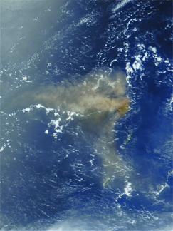
On May 10, 2003, the Anatahan Volcano in
the Northern Mariana Islands erupted in a huge plume of volcanic ash that spread
hundreds of miles across the Pacific Ocean. After a brief respite, Anatahan began
erupting again in March 2004, and in April, the Emergency Management Office of
the Mariana Islands placed the 9-kilometer-long island, which is located about
320 kilometers north of Guam, “off-limits” until further notice and
directed aircraft to pass upwind of the volcano. Image courtesy of Jacques Descloitres,
MODIS Rapid Response Team, NASA/GSFC.
Regardless of alert levels, the airlines require quick notification of an eruption,
ideally within five minutes, and then continual updates regarding the height,
current location and expected track of the ash plume, says Leonard Salinas, program
manager for flight dispatch and safety for United Airlines. Then, the pilot and
the dispatcher make the call whether to divert the plane or land elsewhere. In
the United States, local air traffic controllers may decide to close airspace
up to 60 miles around a volcano. But to avoid placing the plane and passengers
in more danger, pilots and dispatchers have to consider many factors in making
the decision, he says.
“You have to worry about crossing air traffic routes, which requires close
coordination between air traffic control, the pilot and the dispatcher,”
Salinas says. Also, airplanes are loaded with enough fuel to get them from takeoff
to destination, with only a small amount of extra fuel, dependent on conditions
prior to flight takeoff. Thus if the eruption occurs while en route, fuel, in
addition to weather and airport availability, must be taken into account in making
any decisions. Another consideration for the airlines, he says, is that it can
cost more than $100,000 to divert international flights around erupting volcanoes.
Safety, however, is the number one priority, and the best way to increase safety
is to reduce confusion through more efficient communication, Gardner says.
It is important, says Rick Wunderman of the Smithsonian Institution’s Global
Volcanism Program, that pilots and flight crews learn how to handle themselves
if they encounter volcanic ash clouds, such as Rose’s pilot did in Guatemala.
Threats to aviation from volcanic ash are “kind of like terrorism. It’s
not something that we often confront, but we ought to be trained to react quickly,”
Wunderman says.
Although the number of volcanic ash and airplane encounters has gone down in recent
years, even one encounter is too many, says Marianne Guffanti of the U.S. Geological
Survey in Reston, Va., and one of the primary organizers of the June conference.
“An encounter indicates that some part of our mitigation strategy didn’t
work. We’ll never be able to completely eliminate the risk,” but limiting
it is certainly achievable, she says.
Megan Sever
Links:
Volcanic
Ash Conference
Global
Volcanism Program
"Today's volcano risks,"
Geotimes Web Extra, May 24, 2004
"The Infrasound Renaissance,"
Geotimes, June 2004
Back to top
Volcano
refuge ends
 In
1995, thousands of people began to flee the tiny island of Montserrat when the
Soufrière Hills volcano began to erupt. Many refugees went to Britain,
the island’s colonial ruler, but a few hundred people came to the United
States to live with relatives or begin a new life. Now, the Department of Homeland
Security is ending their “temporary protected status” and asking them
to leave.
In
1995, thousands of people began to flee the tiny island of Montserrat when the
Soufrière Hills volcano began to erupt. Many refugees went to Britain,
the island’s colonial ruler, but a few hundred people came to the United
States to live with relatives or begin a new life. Now, the Department of Homeland
Security is ending their “temporary protected status” and asking them
to leave.
Montserrat, located southeast of Puerto Rico, is one of many small islands in
the Lesser Antilles — an island arc formed by the Atlantic Plate subducting
beneath the Caribbean Plate. Most of the volcanoes in the region are steep-sided,
andesitic stratovolcanoes and have explosive eruptions.
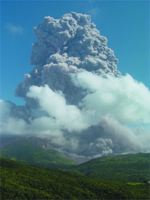
An explosion and partial collapse of
the Soufrière Hills volcano on Montserrat on March 4 sent ash clouds
up 20,000 feet. Since volcanic activity began in 1995, the United States has
offered Montserrat residents safe haven, but that protection is now ending,
despite potential future volcanism there. Image courtesy of Barry Voight.
The eruption that began in 1995 was well-monitored and few people were injured,
although it rendered two-thirds of the island uninhabitable and displaced close
to 8,000 people. “We lost about 95 percent of our housing,” says Richard
Aspin, a spokesman for the Governor’s Office in Montserrat.
Today, the island is still rebuilding. Aspin says that because the volcano has
recently quieted down, a large part of the island is opening back up for habitation.
Once complete, about 500 homes will open up, he says, but “the roads leading
to the area are badly damaged, and a new bridge needs to be built above an old
riverbed, because every time it rains, volcanic debris washes down from the
slopes.” There is a waiting list of about 900 local families for the new
housing, he says, and anyone returning to Montserrat from the United States
would be added to the bottom of that list.
Homeland Security officials acknowledge that it may be unsafe or implausible
for expatriate Montserrat nationals to return to the island, but cite the continued
danger as the reason for ending their temporary protected status. “Although
the conditions in Montserrat continue to warrant concern, the Secretary [Tom
Ridge] has determined that the volcanic eruptions can no longer be considered
temporary in nature,” reads the notice posted online July 6. “Scientists
say that eruptions of the type that have occurred at Soufrière Hills
generally last 20 years, but the volcano could continue to erupt sporadically
for decades.”
Scientists at the Montserrat Volcano Observatory agree that it is difficult
to determine exactly when volcanic activity has stopped. The last major event
took place on July 12, 2003, says Peter Dunkley, acting director of the observatory.
“A very large, active lava dome collapsed, producing large pyroclastic
flows and devastating pyroclastic surges, as well as a series of explosions
over the following days,” he says. “There was even a tsunami at the
climax of the event.”
Since then, activity has become increasingly intermittent and in the past few
months, the volcano has been “very quiet,” Dunkley says. But “it
is too early to say whether the current period of quiescence merely represents
a pause in the eruption,” he says, “or whether it represents the end
of the eruption.” Meanwhile, Montserrat nationals living in the United
States have until the end of February to find somewhere else to go.
Jay Chapman
Geotimes intern
Back to top
Untitled Document
