Alaska's Seward Highway serves as an access point to arguably some of the best skiing, camping, hunting and backpacking in the country. But to witness myriad geologic splendors, visitors need not venture far from the road.
 July and
August are good months to visit the highway, as the weather is warm and the
roads are clear. Designated as a National Scenic Byway and one of 15 "all-American
roads," Seward Highway begins in Anchorage and winds 127 miles before connecting
to the town of Seward. A shorter 50-mile segment, however, from Anchorage to
Portage, can easily fill an entire day of roadside stops, hikes and photographs.
And it also happens to follow along a famous fjord that holds some of the most
extreme tides in the world: the Turnagain Arm.
July and
August are good months to visit the highway, as the weather is warm and the
roads are clear. Designated as a National Scenic Byway and one of 15 "all-American
roads," Seward Highway begins in Anchorage and winds 127 miles before connecting
to the town of Seward. A shorter 50-mile segment, however, from Anchorage to
Portage, can easily fill an entire day of roadside stops, hikes and photographs.
And it also happens to follow along a famous fjord that holds some of the most
extreme tides in the world: the Turnagain Arm.
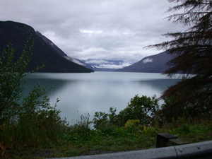
Turnagain Arm (shown here at high tide) is an Alaskan fjord that boasts a tidal bore — a unique steep wall of water. Devoid of ice during the summer months, the arm is easily accessible along the first 50 miles of Seward Highway, where you can stop and wait at various points for the abrupt tidal rises. Courtesy of Igor Smolyar and NOAA.
Turnagain Arm is one of two branches fed by the terminal end of the 150-mile-long Cook Inlet. Carved by glaciers over thousands of years, the arm now measures about 10 miles wide at the mouth near Anchorage, and narrows down to nothing about 40 miles southeast. When the rising tides of Cook Inlet are forced into this limited space, a steep wall of water up to 6 feet high — called a tidal bore — advances at speeds up to 12 miles per hour over the entire length of Turnagain Arm. The event draws a crowd twice daily to witness the only regularly occurring tidal bore in the United States.
About 15 miles out of Anchorage, McHugh Creek at mile 111, marked by a waterfall visible on the other side of the highway, affords the first place to pull over and watch for the tidal bore (without blocking traffic). Also across the highway, a trail leads into Chugach State Park and boasts spectacular viewpoints all the way up to the 4,301-foot-tall McHugh Peak. But for a closer view of the tidal bore, continue to Beluga Point at mile 110 and use their spotting scopes, or forge ahead to mile 96, where an outcropping of bedrock at Bird Point is the perfect place to await the wave. And in accordance with the names, beluga whales, bald eagles and other wildlife are occasionally in view from these spots.
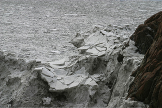
At low tide on Turnagain Arm, water once at highway-level is reduced to a small channel, exposing treacherous mud and silt flats deposited by the bore. Although a trail at Bird Point leads down to the flats, visitors not familiar with the area would be best to stay off the flats; locals tell stories of people and animals becoming stuck in the muck and drowning when the rising tide and approaching wall of water washes over them.
To maximize the tidal-bore experience, timing is everything. The tidal change on a typical day is about 30 feet, but the tidal bore that precedes it may not always be the 6-foot-tall wall preferred by surfers. It may even be difficult to see what sometimes appears like only an approaching ripple.
|
|
|
|
The best time to view a large tidal bore is within the five-day window around a new or full moon, when there is the greatest difference between high and low tides. Next, check a tide chart and find the predicted time for the low tides in Anchorage. The tidal bore usually reaches Beluga Point one-and-a-half hours after that time, and Bird Point two-and-a-half hours after low tide in Anchorage. Depending on wind and tide conditions, the timing may vary, so arrive early. It takes the bore about five hours to travel the entire length of Turnagain Arm, so observers can watch it once, drive south and catch it again.
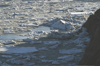
Low tide in Turnagain Arm (upper right) strands ice (in the winter) and silt along the fjord. At the same location (below right), ice resumes its journey down the fjord after the tidal bore brings a large influx of water. Levels of water in Turnagain Arm can fluctuate by 30 feet. Courtesy of Kathryn Hansen.
If you are quick enough to snap a picture of the wave on its first pass, you can instead take the Girdwood turnoff at mile 90 for a change of pace. Here, you can see remnants of the 1964 magnitude-9.2 Good Friday earthquake that caused the land to drop between 6 and 12 feet, flooding the area with saltwater that displaced residents and created a "ghost forest" of dead trees. Relics of the region's mining days also remain, although Girdwood has transitioned into a resort community complete with restaurants, shops and abundant adventure-tour companies.
Girdwood might also be a nice alternative to Anchorage for a place to spend a night or more. Alyeska Prince Hotel offers luxury accommodations — when longer fall nights once again allow the Northern Lights to be visible, guests can ask for a wake-up call to be certain they don't miss a show. Other lodges, hotels, and bed and breakfasts also provide less pricy alternatives.
Although Girdwood may be best for superb skiing during winter months at the Alyeska Ski Resort, summer offers excellent mountain biking, hiking, rafting, golfing, nature watching and, of course, the best time to observe the geology usually hidden beneath the snow. It is also the last place to fill up the gas tank before continuing on to Portage.
 Glaciers
should be on your must-see list, so return to Seward Highway and continue to the
end of Turnagain Arm. Take the exit at mile 78 for about five-and-a-half miles
to the 800-foot-deep Portage Lake, carved out by a glacier of the same name. The
Begich-Boggs Visitor Center shows a short film about glaciers
titled Voices of the Ice, after which curtains open up to reveal enormous
windows with a view of the lake, mountains and glacier. Unfortunately, Portage
glacier has receded more quickly than experts expected when the center was built
in 1985 and is no longer visible. Burns Glacier is the only one evident from shore
without taking advantage of a boat tour onto the lake.
Glaciers
should be on your must-see list, so return to Seward Highway and continue to the
end of Turnagain Arm. Take the exit at mile 78 for about five-and-a-half miles
to the 800-foot-deep Portage Lake, carved out by a glacier of the same name. The
Begich-Boggs Visitor Center shows a short film about glaciers
titled Voices of the Ice, after which curtains open up to reveal enormous
windows with a view of the lake, mountains and glacier. Unfortunately, Portage
glacier has receded more quickly than experts expected when the center was built
in 1985 and is no longer visible. Burns Glacier is the only one evident from shore
without taking advantage of a boat tour onto the lake.
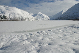
Temperatures are cold enough in winter to freeze over the 800-foot-deep Portage Lake. By summer, however, icebergs are all that remain, and visitors can take a boat tour up to the foot of the glacier that carved the lake over thousands of years. Courtesy of Kathryn Hansen.
Despite the disappearing glaciers and quicksand-like mud, a trip down the Seward
Highway is refreshing; you can still visit pristine landscapes and potentially
dangerous natural phenomena without being fenced out.
Kathryn Hansen
Geotimes intern
Links:
Map
of Seward Highway along Turnagain Arm
Alaska.org
with the best dates and times to view a significant tidal bore
Alaska
Natural History Association with directions and hours for the Begich, Boggs
Visitor Center
Tide
tables for Anchorage
NOAA/NOS
moon phase calendar
Bore
Riders Club with pictures of surfers catching the wave
Girdwood
highlights and accommodations
Kenai
Fjords National Park is home to the active Exit Glacier, and is accessible
by foot
 |
Geotimes Home | AGI Home | Information Services | Geoscience Education | Public Policy | Programs | Publications | Careers |