
| Do you have slides and photos you've
collected from field work or vacations? Every month, we'd like to feature one of your photos from anywhere in the world and invite other readers to guess where it was taken. Look every month in the print Geotimes for a new photo. Following are clues, answers and winners from past issues. |
 |
| Send answers for the July 2005 Where on Earth? contest,
which appears in the print magazine, to Geotimes by July 28 (or postmarked
by this date). From those answers, Geotimes staff will draw the names
of 10 people who will win Where on Earth? T-shirts. And from those 10 names,
we will draw the names of two people who will win a Brunton
compass.
Click here
to submit a guess for this month's Where on Earth?
contest. Submit
photos for Where on Earth? |
|
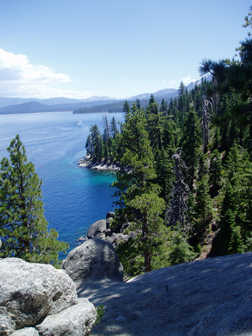
Clues: 1. The area is composed almost entirely of a massive salt-and-pepper-colored granite batholith, underlain by active faults. Huge granite slabs line the many hiking trails in the area. 2. This location is the only place that ever freezes over within the larger body of water and was named because of its gem-like color. More than 60 streams flow into the larger body of water but only one flows out. 3. This bay contains the only island to be found in the more than 190-square-mile water-filled basin. The island is a 150-foot-high granite upthrust, topped by sparse vegetation and remains of a stone structure carried out to the island in the 1920s.
Name the location. Scroll down for the answer |
| Answer: Check back next month for the answer to and winners of the June Where on Earth? in Geotimes. |
|
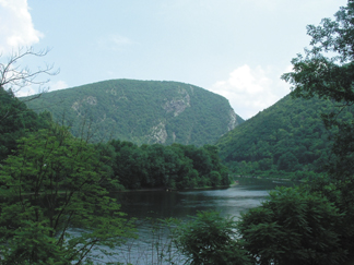
Clues: 1. The main rock formation in this area, of Silurian age, is full of pure quartz, making it highly resistant to erosion. Nonetheless, the deep mountain pass pictured here was carved out of a flat river plain over the past several million years by one of the few remaining undammed rivers in the region. It is one of many ravines formed by wind or water in the high ridges of a long mountain chain. 2. During the most recent ice age, glaciers reached just south of this area and have left behind telltale signs. 3. The park surrounding this ravine is more than 109 square miles and offers outdoor recreational opportunities, including hiking, canoeing and kayaking. Visitors will see remnants of past inhabitants: from native campsites and colonial homesteads to copper mines that were active as recently as the early 1900s.
Name the feature. Scroll down for the answer |
| Answer: The Delaware Water Gap National Recreation Area spans the border between Pennsylvania and New Jersey. Travelers along U.S. Route 209 pass through this spot. Image courtesy of Donald Smith. |
May 2005
Winners
Jeremy Apgar (Wantage, N.J.)
Steve Dutch (Green Bay, Wis.)
Tom Hawisher (Savoy, Ill.)
Charles Hutchinson (Tucson, Ariz.)
Hugh Rance (Flushing, N.Y.)
Bruce Sloane (Sperryville, Va.)
Daniel Snare (Golden, Colo.)
David Speidel (Forest Hills, N.Y.)
Liane Stevens (Waltham, Mass.)
Jeanne Thibeault (Spencer, Mass.)
 |
Geotimes Home | AGI Home | Information Services | Geoscience Education | Public Policy | Programs | Publications | Careers |