
|
 Subscribe

Answer Archive
To submit an answer to the current Where
on Earth? click
here.
To offer photographs for Where
on Earth? send an E-mail message to earth@earthmagazine.org.
2001: January February March April May June July August September October November December
2002: January February March April May June July August September October November December
2003: January February March April May June July August September October November December
2004: January February March April May June July August September October November December
2005: January February March April May June July August September October November December
2006: January February March April May June July August September October November December
2007: January February March April May June July August September October November December
2008: January February March April May June July August
August 2008
|
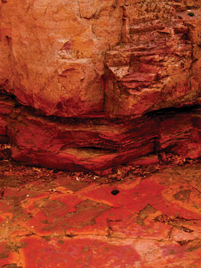
Clues: 1.
This quarry is the most famous source of catlinite, the malleable red stone that Native Americans used to make ceremonial pipes and effigies. The once red clay was turned to stone after compression between layers of hard quartzite. 2.
The Sioux, Crow, Blackfoot, Ojibwa, Dakota, Pawnee and Lakota tribes all traveled hundreds of kilometers to this site to quarry the sacred red stone. The quarry itself was also sacred — a green zone among warring tribes — and is still sacred today. Native Americans retain exclusive quarrying rights. 3.
The quarry was an important landmark for pioneers traveling west on the Oregon Trail. Pioneers carved their names and the date, still visible today, into the hard Sioux quartzite rock surrounding the quarry. Give the quarry’s name and its location. Scroll down for the answer |
| Answer: The quarries at Pipestone National Monument in Minnesota are a source of catlinite, a red stone used by Native Americans to make ceremonial items. Thanks to Marie Grogan of Wauwatosa, Wis., for the following clue corrections: Inscriptions in the rock overlooking the quarries were carved by members of an 1838 U.S. government expedition led by scientist Joseph Nicollet, not by settler pioneers along the Oregon Trail; also, the names Sioux, Dakota and Lakota refer to the same people, not different tribes. Photo is by Mary Caperton Morton. |
August 2008 Winners
Gary Carnaghi (Tulsa, Okla.)
Martha Carr (Atlanta, Ga.)
Will Harridge (Marengo, Ill.)
Curtis Hudak (Stillwater, Minn.)
David Probert (Strathmore, Wellington, New Zealand)
John T. Schulenberg (Kerrville, Texas)
Laurie S. Severson (Duluth, Minn.)
Harry L. Siebert (Dolores, Colo.)
John D. Vitek (College Station, Texas)
Beverly F. Vogt (Portland, Ore.)
July 2008
|
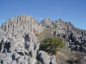
Clues: 1.
This ancient observatory, discovered in 2001, is composed of giant stones arranged to precisely track the movement of the sun and moon throughout the year. The site is about 3,800 years old, dating to the Bronze Age. 2. The observatory also tracks the autumnal and vernal equinoxes and winter and summer solstices, and has a marker indicating the movements of the constellation Pleiades. 3.
The site is one of the five oldest observatories in the world, according to NASA. Name the observatory and its location. Scroll down for the answer |
| Answer: Macedonia’s megalithic Kokino Observatory is one of the oldest in the world, about 3,800 years old. The giant stones are arranged to track the movements of the sun and the moon, as well as the equinoxes in autumn and spring. One marker also tracks the movements of the constellation Pleiades. In a NASA list of ancient observatories, Kokino is joined by Great Britain’s Stonehenge, New Mexico’s Chaco Canyon and Peru’s Macchu Picchu. Photo is by Panovska Sanja. |
July 2008 Winners
Jim Berg (Bismarck, N.D.)
Richard Bonello (Price, Utah)
Frank Cressy (Bakersfield, Calif.)
David McMullin (Wolfville, Nova Scotia)
Pete Modreski (Lakewood, Colo.)
Jim Motyka (Taftville, Conn.)
Bill Siesser (Nashville, Tenn.)
Kaeti Stoss (Rochester, N.Y.)
Brook Stuber (Decatur, Ga.)
Anne Thompson (Vancouver, British Columbia)
June 2008
|
Clues: 1.
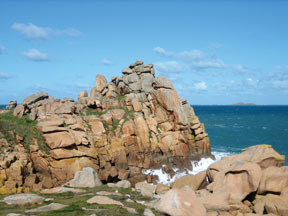
These 300-million-year-old, pink-colored boulders, which are often deformed and eroded into interesting shapes, can be seen by hikers trekking along a 14-kilometer-long coastal footpath that runs along a northern coastline of their host country. More of the boulders are visible under the waves, or have crumbled to form small, sandy pink beaches. 2. The footpath was created in 1791 for guards watching for smugglers, and now winds around clifftops and through fern forests and several resort towns along the windswept coast. 3.
According to local legend, the seaside grottoes along this coastline are inhabited by 900-year-old mythical sprites, who (legend has it) emerge at night to dance around fires. Name the coast along which these rocks are found, and the host country. Scroll down for the answer |
| Answer: The Côte de Granit Rose (the Pink Granite Coast) stretches from Plestin-les-Grèves to Louannec on the northern coast of Brittany, France. Visitors can inspect the tumbles of granite boulders, eroded by wind and water into strange shapes, from a 14-kilometer-long footpath along the coastline. The coarse-grained granite, which intruded 300 million years ago into 2-billion-year-old gneiss, gets its rosy color from an abundance of large grains of pinkish alkali feldspar. Photo is by Mo Small. |
June 2008 Winners
Christopher A. Anderson (Green Bay, Wis.)
Claude E. Bolze (Sapulpa, Okla.)
Jerry Dolence (Reno, N.V.)
Charles R. Gilchrist (Clifton Park, N.Y.)
Ann Proske (Lubbock, Texas)
William C. Robinson (Lubbock, Texas)
Jennifer Standish (Bainbridge Island, Wash.)
Mike Sweet (Houston, Texas)
Don Whitley (Houston, Texas)
Debbie Ziegler (Hannibal, Mo.)
May 2008
|
Clues: 1.
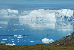
The glacier that calved these giant icebergs is one of the fastest and most active glaciers in the world, flowing 19 meters per day and disgorging more than 35 cubic kilometers of ice per year into a fjord — enough to supply New York City’s annual water requirements. The glacier is part of a UNESCO World Heritage Site. 2.
The glacier lies 250 kilometers north of the Arctic Circle, not far from one of the largest towns in its host country. The region may have been settled as much as 3,500 years ago. Because it is easy to get to, scientists have been studying the glacier for 250 years . 3. The icebergs in the photograph have been grounded within the fjord on a submerged terminal moraine (a pile of unconsolidated rocks and debris that marks the maximum advance of a glacier). They may remain there for years until they are broken up by the force of the glacier or other icebergs. Name the glacier and the UNESCO site. Scroll down for the answer |
| Answer: Sermeq Kujalleq, one of the fastest glaciers in the world, flows into Greenland’s Ilulissat Kangerlua (also called Jakobshavn Icefjord) at a rate of 19 meters per day. Ilulissat Kangerlua was awarded UNESCO World Heritage Site status in 2004. Many of the giant icebergs in the icefjord, some the size of city blocks, are moored on a submerged terminal moraine. Photo is by Bruce Sloane. |
May 2008 Winners
Antonio Arribas (Castle Rock, Colo.)
Les Beard (Oak Ridge, Tenn.)
Charles R. Bentley (Madison, Wis.)
Tony Bollasina (St. Louis, Mo.)
Sandy Deiber (Carol Stream, Ill.)
Russell P. Kennedy (Gaithersburg, Md.)
James Miller (Schaumburg, Ill.)
Mike Ranck (Morrisville, N.C.)
John R. Reid (Fort Collins, Colo.)
Mike Stickney (Butte, Mont.)
April 2008
|
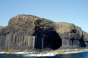
Clues: 1.
Found on an uninhabited island, this giant seaside cave (which has been said to be as tall as a cathedral) was named for one of its country’s mythical heroes. 2.
The walls of the cave were formed by the same ancient basaltic lava flow as a more famous site in a nearby country, where the cooling lava produced similar geometrically shaped formations.
3. Previously given a different name for the musical sounds of the waves echoing through it, the scenic cave has been visited by royalty, has served as the inspiration for artists, musicians and writers, and, more recently, even inspired a rock song. Name this site and its location. Scroll down for the answer |
| Answer: Fingal’s Cave, on the uninhabited Isle of Staffa in Scotland, is a giant seaside cave that is part of a National Nature Reserve. Fingal (or Fionn mac Cumhaill in Irish mythology) is the hero of an old Gaelic poem; according to the legend, Fionn built a path, or causeway, across the sea from Ireland to Scotland to fight an enemy. The legend corresponds with the geology. Photo is by Diane Kightlinger. |
April 2008 Winners
Tom Baillieul (Columbus, Ohio)
Charles F. Berkstresser (Sacramento, Calif.)
Tom Hanley (Midland, Ga.)
Jacq Marie Jack (Atlanta, Ga.)
Milton R. Marks (Lake Oswego, Ore.)
Bill Romey (East Orleans, Mass.)
Brian Salem (Tijeras, N.M.)
Daniel B. Sanger (North Huntingdon, Pa.)
Kevin Shelton (Columbia, Mo.)
Jaye R. Stanley (Houston, Texas)
March 2008
|
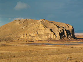
Clues: 1.
In 1805, as Lewis and Clark continued their Corps of Discovery expedition across North America, they came upon a hill that their guide Sacagawea identified as a landmark marking the way to her people’s summer retreat — very good news for the travelers, who were anxious to locate it. The hill was named for its resemblance to an animal. 2.
The landmark hill, an uplifted block of limestone, was exposed after the sediments around it eroded. It is part of the Mission Canyon Formation and rises above a local river flood plain that bears the same name as the landmark. 3. The limestone formation’s 300-meter-thick base forms the largest artesian aquifer in the United States, and is recharged by precipitation and surface water. The formation also contains many fossils of crinoids and bryozoans, which were abundant when it was deposited. Name this landmark and its location. Scroll down for the answer |
| Answer: Beaver’s Head Rock in western Montana is a limestone exposure of the Mississippian Canyon Formation. In August 1805, as Lewis and Clark continued their travels across North America, their guide Sacagawea identified the rock as marking the way to her people’s (the Shoshone) summer retreat. That was good news to the explorers, who were anxious to find horses to help them cross the mountains. Photo is by Joe Scyphers. |
March 2008 Winners
Lynne Dickman (Missoula, Mont.)
Patrick Druckenmiller (Fairbanks, Alaska)
Rick Farrand (Denver, Colo.)
Barbara Gauthier-Warinner (Interlochen, Mich.)
Nancy Lamm (Montrose, Colo.)
Nancy Piltch (Olmsted Falls, Ohio)
Annika Swanson (Baker City, Ore.)
Tyler Treece (Stillwater, Okla.)
Ken Von Buettner (Omaha, Neb.)
G. D. Webster (Pullman, Wash.)
February 2008
|
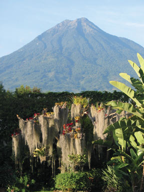
Clues: 1.
This volcano, part of a chain of volcanoes associated with the subduction of a tectonic plate, is a classic stratovolcano that likely formed during the Holocene. Its symmetrical cone is made up of sequential layers of lava flows, ash and mudflows. The volcano towers more than 2,100 meters above a historical city. 2.
The volcano has been inactive in historical times, although heavy rains can produce swift debris flows down its steep sides that endanger several cities situated within 10 kilometers of its slopes. Following one such lahar, which destroyed a nearby city in the 16th century, the volcano — once named for the flowers that grew in its rich soil — was given a new name. 3. The volcano’s slopes are currently farmed for a stimulating beverage. Name this volcano and its location. Scroll down for the answer |
| Answer: Guatemala’s Volcán de Agua (Volcano of Water) was once called Hunapú, or “place of flowers,” but was renamed in 1541 by Spanish conquistadors when a swift-moving lahar, or mudflow, buried the original capital of Guatemala. Coffee farms now carpet the volcano’s lower slopes. Photo is by Jim Berg. |
February 2008 Winners
Alison Davis (Gainesville, Fla.)
Wayne Greer (Corpus Christi, Texas)
Michael Guebert (Upland, Ind.)
John H. Hall Jr. (Shenandoah, Texas)
Mike Maysey (San Clemente, Calif.)
Christina McDonald (Winnipeg, Manitoba)
Anthony Monasterio (Golden, Colo.)
Ann Proske (Lubbock, Texas)
Roland Rueber (Eureka, Calif.)
Christy Shorey (Gainesville, Fla.)
January 2008
|
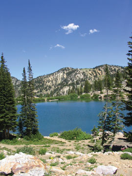
Clues: 1. This hidden lake, at an elevation of about 2,800 meters, is nestled in alpine meadows that are abundant with wildflowers in the late summer. The lake is reachable by a short, easy hike within a tree-named canyon sculpted by a glacier sometime in the last 25,000 years. 2. The unconventional spelling of this lake’s name is the result of a misspelling of its more traditional name on a mining claim from the mid-1800s — and the name stuck. 3. The mountain range that contains the lake is about 257 kilometers long. According to some sources, the mountain range got its name from an Indian word for a high mountain pass. Name the lake and its location. Scroll down for the answer |
| Answer: Cecret Lake in the Wasatch Mountains of Utah is an alpine lake that received its unusually spelled name from a mining claim in the mid-1800s. The lake, at an elevation of 2,800 meters, is hidden within a canyon carved by a glacier. Photo is by Mark Stephenson. |
January 2008 Winners
Claude E. Bolze (Sapulpa, Okla.)
Jan E. Callister (Draper, Utah)
Charles Cannon (Oregon City, Ore.)
Thomas R. Fisher (Golden, Colo.)
Diane M. Lightwood (Reno, Nev.)
William Pariseau (Salt Lake City, Utah)
Charles C. Roll (Gansevoort, N.Y.)
Roy Spitzer (Longmont, Colo.)
Jim Sukup (Indianapolis, Ind.)
Jarett Zuboy (Golden, Colo.)
2000: January February March April May June July August September October November December
2001: January February March April May June July August September October November December
2002: January February March April May June July August September October November December
2003: January February March April May June July August September October November December
2004: January February March April May June July August September October November December
2005: January February March April May June July August September October November December
2006: January February March April May June July August September October November December
2007: January February March April May June July August September October November December
2008: January February March April May June July August
