
|
 Subscribe

Where on Earth? Answer Archive
To submit an answer to the current Where
on Earth? click
here.
To offer photographs for Where
on Earth? send an E-mail message to earth@earthmagazine.org.
2001: January February March April May June July August September October November December
2002: January February March April May June July August September October November December
2003: January February March April May June July August September October November December
2004: January February March April May June July August September October November December
2005: January February March April May June July August September October November December
2006: January February March April May June July August September October November December
2007: January February March April May June July August September October November December
2008: January February March April May June July August
December 2007
|
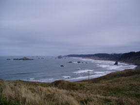
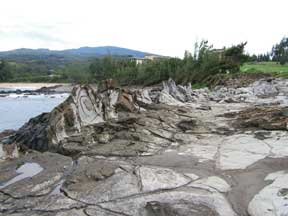
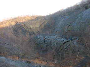
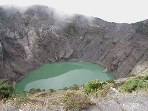
Clues: 1. This regional park claims to be the westernmost point on the mainland of its host country, but another site a few hundred kilometers north also claims that distinction. Whale-watching, clamming, sport fishing and scientific research are popular activities. 2. This site sits on several faults and is near where three tectonic plates meet; subduction here is causing some of the world’s highest rates of coastal uplift at 2.5 centimeters per 30 years. The rocks here range from 180-million-year-old dark-colored Jurassic conglomerates at the base of the cliffs and in the sea stacks to 7-million-year-old white sands and silts at the top of the cliffs, which gave the site its name. 3. After the numerous reefs and offshore islands were determined dangerous to the maritime culture off the coast, a lighthouse was constructed here in the 19th century. The lighthouse is the oldest original tower in the region and has one of the oldest continuously operating lights in the region. Name this site and location. Scroll down for the answer |
| Answer: Cape Blanco, in Cape Blanco State Park along Oregon’s southern coast, is the westernmost point in Oregon and claims to be the westernmost point in the contiguous United States, although so do Cape Flattery, Wash. (at low tide), Cape Alava, Wash. (at high tide) and Cape Mendocino in Humboldt County, Calif. The lighthouse on the cape, the oldest in Oregon, was constructed in 1870 to warn ships away from the cape’s offshore reefs. Photo is by Megan Sever. |
December 2007 Winners
Andrew Alden (Oakland, Calif.)
Glen Dodd (Traverse City, Mich.)
Donna Goss (Harbor, Ore.)
Mark Grivetti (Santa Barbara, Calif.)
Herb Meyer (Divide, Colo.)
Paula LaPoint (Chapel Hill, N.C.)
Paul Segovis (Rexford, N.Y.)
Todd Smith (Onalaska, Wis.)
Shelli Swanson (Baker City, Ore.)
Chris Thurner (Denver, Colo.)
November 2007
|
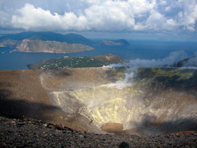
Clues: 1. This island with an influential name is part of an archipelago named to honor an important god (who was also said to reside here). Another ancient legend holds that this island was the site of a different god’s fiery work. 2. The archipelago of which this island is a part, now a UNESCO World Heritage Site, was once the site of a famous battle between two ancient empires. 3. A volcano was once the central feature of a nearby separate islet that is now connected to this island by an isthmus. The main island hosts several other stratovolcano cones, one of which (its large crater is pictured here) last erupted more than a century ago. The island has also lent its name to a type of explosive eruption that occurred there. Name the crater and the island. Scroll down for the answer |
| Answer: Vulcano Island in the Aeolian Islands off of Sicily, Italy, was named for Vulcan, the Roman god of fire, who was said to live and work his forge within the volcano. The island has lent its name to all volcanoes, and also to a “Vulcanian” type of eruption, which begins with a noisy explosion after a long period of dormancy, followed by the ejection of lava bombs and rocks, as well as ash and pumice. Vulcano’s Gran Cratere last erupted in 1889-1890. Photo is by Trina Riegel. |
November 2007 Winners
Mark Avery (Lansing, N.Y.)
Daniel Bernoulli (Basl, Switzerland)
Charles Cannon (Oregon City, Ore.)
Lee A. Copp (St. Clair Shores, Mich.)
John Hora (Madison, Wis.)
Sandra Lilligren (Clarkston, Wash.)
David Pratt (Queensbury, N.Y.)
Sandra Ramsey (Quincy, Calif.)
Daniel Snare (Golden, Colo.)
Deb Ziegler (Hannibal, Mo.)
October 2007
|
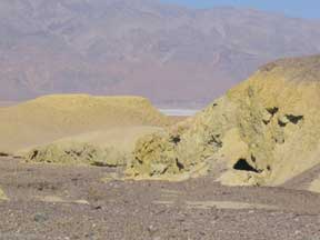
Clues: 1. The eroding hills of a Pliocene formation fill this canyon, named for the brightly colored sediment that covers the hills. 2. The canyon, found in a valley of extremes, was originally settled by miners looking for gold but contains a different kind of mineral treasure. One of the region’s first operations to process the mineral is situated near this canyon and was built in the late 19th century. 3. The formation’s silty mudstones, which predate the valley, were originally deposited in lakebeds, but faulting and volcanism in the region during the Tertiary formed new mountains and valleys, washing the sediment into the canyon and mixing it with volcanic ash to form the mineral-rich formation. Name the canyon and its location. Scroll down for the answer |
| Answer: Mustard Canyon in Death Valley, Calif., is named for the mustard-colored hills of the eroding Furnace Creek Formation. The canyon is home to remnants of the Harmony Borax Works, and rumor has it that parts of the Star Wars movies were filmed here. Photo is by Heather Brown. |
October 2007 Winners
Richard Bonello (Price, Utah)
Thomas Bugo (Diamond, Nev.)
L. David Carter (Sequim, Wash.)
David Eckhardt (Masonville, Colo.)
Heather Gang (Pahrump, Nev.)
Michael Machette (Denver, Colo.)
Ted Reeves (Ontario, Calif.)
Jamie Smith (Los Gatos, Calif.)
Neil Turner (Fulshear, Texas)
Sandra Underwood (Bozeman, Mont.)
September 2007
|
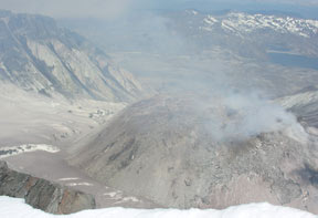
Clues: 1.This stratovolcano is one of the host country’s most active explosive volcanoes, and is arguably its most infamous. In the past, however, it has not produced the country’s largest eruptions. Researchers have found that the region that hosts this volcano holds evidence of “supervolcano” eruptions in the geologic record. 2. This volcano is building a composite lava dome inside its crater. In April, researchers measured the lava dome at almost 93 million cubic meters. It has been growing at an average rate of almost 0.3 cubic meters per second. 3. The largest-known eruption of this volcano — which was named in the late 18th century by a British explorer — was given a Volcanic Explosivity Index (VEI) of 5. Name the volcano and its location. Scroll down for the answer |
| Answer: The lava dome growing in the crater of Washington’s Mount St. Helens had grown to about 93 million cubic meters when this photo was taken in May 2007. The stratovolcano is one of America’s most active explosive volcanoes, and erupted catastrophically in May 1980. That eruption killed 57 people and became both the deadliest and most economically destructive volcanic event in the history of the United States. Photo is by Bob Carson. |
September 2007 Winners
Gena DeAragon (Spokane, Wash.)
Andrew Freed (El Paso, Texas)
Ben Frieman (Inver Grove Heights, Minn.)
Craig Goodknight (Grand Junction, Colo.)
Adam R. Goss (Gainesville, Fla.)
Karin Jennings (Bozeman, Mont.)
Jennifer B. Leinart (Spokane Valley, Wash.)
Ken Simonton (Decatur, Ga.)
Mark Sweeney (Vermillion, S.D.)
Rich Zinkl (Grand Junction, Colo.)
August 2007
|
Clues: 1.On the western side of this volcanic island, the lava is different from the rest of the lava on the island: It is lighter in color, denser and is fine-grained. It has been further bleached by years of ocean spray. This particular flow marked one of the last lava flows on this island, more than 200 years ago. 2. Wave energy against the flowing lava caused the lava to harden in an upward, jagged formation. This area was named for the jagged points of this formation that look like the teeth of fiery mythical beasts. 3. The site lines the edge of a golf course and resort; golfing is a popular activity in this area thanks to the beautiful landscape and weather that hovers around 27 degrees Celsius (80 degrees Fahrenheit) year-round. Name this point and its location. Scroll down for the answer |
| Answer: The jagged formation at Makalua-puna Point, Kapalua in West Maui, Hawaii (better known as Dragons Teeth) was created by one of the last lava flows on the island, which was subsequently shaped into a teeth-like ridge by wind and the sea. Visitors reach the point by taking a five-minute hike through a golf course. Photo is by Tracey Ford. |
August 2007 Winners
Karen Berry (Wheat Ridge, Colo.)
Michael Foster (Houston, Texas)
Paul Franks (Tulsa, Okla.)
David Goldak (Andover, Kan.)
Wallace Judd (Denver, Colo.)
Adam Rawe (Jacksonville, Ill.)
William Robinson (Lubbock, Texas)
Lisa Rossbacher (Marietta, Ga.)
Mike Snyder (Santa Clarita, Calif.)
David Swanson (Baker City, Ore.)
July 2007
|
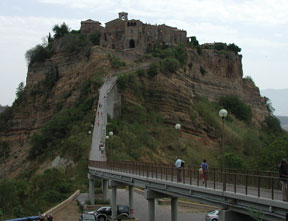
Clues: 1.This village has existed for more than 2,500 years. The population used to be much greater than today’s mere 15 residents, as the 430-meter-high (more than 1,400 feet) village was once an important stop along an ancient road that connected to a number of trade routes throughout the region. 2. This village and the sedimentary tufa hill it sits on are slowly eroding away, due to wind and the two rivers that cut through the surrounding valleys. The natural bridge that once connected the village to its slightly bigger sister town has also eroded away. Now the only way to get to this village is to park at the base of the pinnacle and hike up a footbridge that is 1.6 kilometers (1 mile) long. 3. The greater region is often called the “Green Heart” of the host country, in reference to its lush river valleys and medieval hill towns. The village itself is often called “The Dying City.”
Name the village and its location. Scroll down for the answer |
| Answer: Civita di Bagnoregio is a tiny little town of 14 or so residents (depending on who you ask), perched atop an eroding hillside in Umbria, Italy. It is only accessible by a footbridge that connects it to its bigger sister city, Bagnoregio. Civita is said to have first been settled by Etruscans some 2,500 years ago. Photo is by Adam Boggs. |
July 2007 Winners
Francesca Ghisetti (Dunedin, New Zealand)
Rusty Johnson (Tulsa, Okla.)
Tom Kartrude (Florence, Ore.)
Bill Laprade (Seattle, Wash.)
Jimmy Lawhon (Bryant, Ark.)
Lloyd Litwin (Saskatoon, Saskatchewan)
Rick Sibson (Dunedin, New Zealand)
Ellen Thomas (New Haven, Conn.)
Gregory Vandeberg (Grand Forks, N.D.)
Jill Yeomans (Santa Barbara, Calif.)
June 2007
|
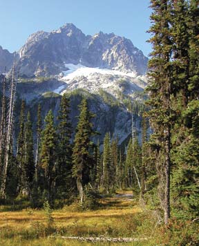
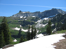
Clues: 1.This granite mountain, which formed about 90 million years ago during the Cretaceous period, is located in a volcanically active range but isn’t volcanic itself. At 2,970 meters (more than 9,400 feet), it is the second highest non-volcanic peak in this region. 2. The peak shares its name with a small range within the larger volcanic range. This mountain is the highest peak in the smaller range; however, it is less known for its overall elevation than for its craggy cliffs, at least one of which rises about 1,525 meters (5,000 feet) in just over 3 kilometers (2 miles). It is most notable for its sheer granite face that towers above a glacier. 3.This prominent peak can be seen from the summits of many other peaks in this region, and is a popular hiking spot, especially during the summer months, as the ascent does not traverse glaciers and can be done in a day.
Name the mountain and its location. Scroll down for the answer |
| Answer: Mount Stuart lies within the Stuart Range in the Cascades in Washington. It is the highest peak in the Stuart Range. Photo is courtesy of Kathryn Hansen. |
June 2007 Winners
Bruce Bjornstad (Richland, Wash.)
Sandra Cannon (Vista, Calif.)
Bruce Garbaccio (Sierra Madre, Calif.)
Chris Higgins (Davis, Calif.)
Neal Jacques (Burien, Wash.)
Ryan Keeler (Cary, Ill.)
Chuck Park (Bellingham, Wash.)
Charles Roll (Gansevoort, N.Y.)
Mike Stickney (Butte, Mont.)
Bruce Weertman (Seattle, Wash.)
May 2007
|
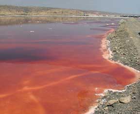
Clues: 1.This 104-square-kilometer saline, alkaline lake near a vast volcanic crater is recharged by volcanic hot springs. The natural trona, an evaporite mineral, gives the lake its pink color. Companies lining the lake collect the minerals and process them into soda ash, which is used for glassmaking. 2. Thanks to the vast salt flats that surround the lake and keep predators away, during the dry season, thousands of pink flamingoes are also known to color the lake. 3. This lake, at the southern end of an ancient and still spreading rift valley, is shown in the film The Constant Gardener, though in the film the lake is called by another name. In a local language, the name of the lake actually means “salt.”
Name the lake and its location. Scroll down for the answer |
Answer: Lake Magadi is the southernmost lake in the Kenyan Rift Valley. The alkaline lake, located near the Ngorongoro crater, is fueled by volcanic hot springs. The lake appears pink or red, thanks to the halophilic aerobic archaebacteria that live in the saline water (not due to the natural trona, as we stated in the original clues). Photo is by Alex Guth. |
May 2007 Winners
Jim Berg (Bismark, N.D.)
Jerry Dolence (Reno, Nev.)
Tom Hawk (Orland Park, Ill.)
Chris Huenink (San Antonio, Texas)
Kathy Lehtola (Hillsboro, Ore.)
Christopher Schuberth (Marlton, N.J.)
Charles Sehulster (Crompond, N.Y.)
Susan Soloyanis (Cascade, Colo.)
Tara Stolz (Vandalia, Ohio)
Nick Taranick (Twin Peaks, Calif.)
April 2007
|
Clues: 1.This convex fold structure has long been used as a natural laboratory for structural geology students, as it so clearly illustrates the folds and thrust belts of this valley and ridge province. The jumbled sedimentary and metamorphic rocks date to a mountain building event from 350 million to 300 million years ago. 2. This structure, named after the part of the body of the animal it resembles, is visible thanks to a strip mine. Some cliff-like parts of the massive structure are up to 21 to 24 meters high. The name of this region also comes from an animal, albeit a different one. 3. Since the mine that exposes this structure closed, rumor has it that it has been frequently used for target practice, offroad bicycling, hiking and illicit drinking, as well as a geology lab.
Name this feature and its location. Scroll down for the answer |
| Answer: Most geology students and geologists in the Northeast will recognize the Whaleback anticline in the Bear Valley strip mine near Shamokin, Pa., thanks to the many field trips to the site to study structural geology. Photo is by Sam Schon. |
April 2007 Winners
Diane Anderson (Enola, Pa.)
Eric Brosius (Levittown, Pa.)
Megan Crocker (Geneva, N.Y.)
Shelley Judge (New Concord, Ohio)
Anne Lutz (Harrisburg, Pa.)
Noel Potter (Carlisle, Pa.)
Jason Sheasley (Ponte Vedra Beach, Fla.)
Maria Skidmore (Warrington, Pa.)
Kara Stetler (Easton, Pa.)
John Stimac (Charleston, Ill.)
March 2007
|
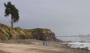
Clues: 1.These bluffs are part of a local park that borders a larger state park famous for its beaches. The smaller park got its name from the natural petroleum product seeping out of the cliffs. The bluffs are at the coast of a community named for a native “carpentry shop,” where the natives built fancy seagoing canoes and sealed them with the natural substance that was oozing out of the cliffs. 2. The bluffs are permeated with this petroleum product, which originated in shale in the late Miocene period. The sticky substance has impregnated overlying Pleistocene alluvial deposits that show pebbly layers and cross-bedding. Both formations are exposed in the bluffs along the beach. 3. Fossilized Pleistocene birds and plants have been found at this site, and not far away, this same formation famously sealed the fates of many large Pleistocene mammals. The park itself is just a few kilometers from one of the best surfing areas in the host region.
Name the park and its location. Scroll down for the answer |
| Answer: Tar frequently leaks out of the beach and bluffs in Tar Pits Park in Carpinteria, Calif., near Carpinteria State Park in Santa Barbara County. Spanish visitors named the area after the large seagoing canoe-building enterprise, or carpentry shop, that the Chumash tribe had along the beach. Photo is courtesy of Edward Grew. |
March 2007 Winners
Angela Chandler (Little Rock, Ark.)
Ann Coppin (Westminster, Calif.)
Fred Guthrie (Crossville, Tenn.)
Ralph L. Horak (Plano, Texas)
Drew Mayerson (Camarillo, Calif.)
Karin Rice (Long Beach, Calif.)
Lew Rosenberg (Tijeras, N.M.)
Neil Sanvordenker (Santa Barbara, Calif.)
Robert Seklemian (Denver, Colo.)
Jay Smerekanicz (New Boston, N.H.)
February 2007
|
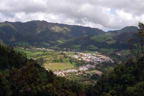
Clues: 1.This village is located in a caldera in a string of nine volcanic islands that form where three tectonic plates come together. The host island for this village and caldera — which share a “hot” descriptive name — is known for the verdant color of its lowland fields and meadows and highland forests. 2. The volcano that formed this particular caldera is a historically active stratovolcano. It last erupted in the 1600s, causing significant damages and fatalities. Volcanic eruptions on the host island chain have been rumored to be remnants of Atlantis. 3.This village and caldera are particularly known for a tradition in which locals cook casserole-type meals in holes in the ground that are heated by geothermal activity. Following the meals, visitors often bathe in the hot mud pits or hot springs.
Name the village and caldera, and their location. Scroll down for the answer |
| Answer: The village and caldera of Furnas share the same name. Furnas is located on São Miguel, one of nine volcanic islands in the Azores Island chain in the Atlantic Ocean, about 1,500 kilometers off the coast of Portugal. One tradition involves cooking by burying casseroles of meats and vegetables in the geothermally heated ground. Photo is by Jay Gregg. |
February 2007 Winners
Raili Aumo (Ojakkala, Finland)
Alison Davis (Gainesville, Fla.)
Nancy Hernandez (Gainesville, Fla.)
Ross Jones (Libertyville, Ill.)
Dave Kuentz (Oxford, Ohio)
Ralph Langenheim (Urbana, Ill.)
Candy Martinez (Fremont, Calif.)
Christy Shorey (Gainesville, Fla.)
Bill Siesser (Nashville, Tenn.)
Elizabeth Widom (Oxford, Ohio)
January 2007
|
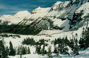
Clues: 1. This feature is a long, narrow ridge that formed when two glaciers carved into opposite sides of the same mountain. It separates two glacial valleys in an icy national park that used to host some 150 glaciers. This “wall” is one of the more prominent features in the park. 2. The exposed sedimentary rocks in the park range from 1.6 billion to 800 million years old, and are virtually unaltered. Hikers can often see ripple marks, mud cracks and impressions of raindrops that are hundreds of millions of years old. 3. Though carved by ice, the name of this feature evokes a more summery, green feel. An 84-kilometer-long road that carves through the park traverses this feature. Vehicle restrictions abound, however, as do seasonal restrictions. Sometimes, cross-country skiing is the only way to get around.
Name the feature and its location. Scroll down for the answer |
| Answer: One of Glacier National Parks (in Montana) more recognizable features, Garden Wall is a great example of an arête, a long, narrow ridge carved on both sides by glaciers. It is viewable from the Going to the Sun Road, which winds through the park. Photo is by Larry Fellows, courtesy of the Earth Science World Image Bank. |
January 2007 Winners
Cherie Arrow (Yellowknife, Northwest Territories)
Marie Grogan (Wauwatosa, Wis.)
Christopher Howard (Russellville, Ark.)
William Lukens (Sandpoint, Idaho)
Randall Mattzela (Cibolo, Texas)
John Murray (Teulon, Manitoba)
Joyce Norton (Grayslake, Ill.)
Chris Scott (Brentwood, Tenn.)
Tim Scrivner (Ava, Mo.)
Larry Smith (Butte, Mont.)
December 2006
|
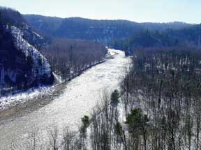
Clues: 1. The creek that incised this 20-kilometer-long valley, 90 to 120 meters deep into Devonian-aged shales and siltstones formed some of the deepest gorges in this region. The valley was shaped by post-glacial headwater erosion at the end of the last ice age and continues to deepen as the creek winds its way from mountains, across a fertile plain to a great lake. 2. In the early 1800s, the region reportedly hosted a shale mine, lime kilns, sawmills, and a few oil and gas wells. Today, however, this valley hosts wildlife and conservation sanctuaries, surrounded by old growth forests. 3. Whitewater rafters, paddlers and fishermen love this valley. So too, do nudists — in the same valley, there is a nudist beach and swimming spot. It may not be legal to swim or be nude in the area, but rumor has it the site has been noted for its au natural swimming and sunbathing for more than 100 years.
Name this valley and its location. Scroll down for the answer |
| Answer: The Zoar Valley in western New York is actually a series of deep gorges and valleys carved by the Cattaraugus Creek as it winds its way to Lake Erie. Zoar Valley is one of the largest remaining old growth forests in the eastern United States. Photo is by David Pratt. |
December
2006 Winners
Claude Bolze (Sapulpa, Okla.)
Todd Bown (Rochester, N.Y.)
David Goldak (Andover, Kan.)
Jeff Over (Geneseo, N.Y.)
Paul Segovis (Rexford, N.Y.)
Mark Svereika (Cortland, N.Y.)
Jill Tarabula (Williamsville, N.Y.)
Joshua Trott (Cumberland, Md.)
November 2006
|
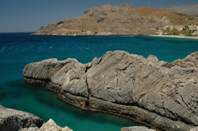
Clues: 1. Twenty-five million years ago, this bay’s host island was connected to the mainland. By 8 million years ago, a sea had grown up around it, turning it and many nearby locales into islands. Millions of years of uplift and subsidence, and sea-level rise and fall, have left the island rugged and difficult to pass, with some 3,000 caves and caverns and more than 100 gorges and bays, including the one seen here. 2. This location is prone to natural hazards. An earthquake in A.D. 365 caused massive uplift of the western half of the island, including the Mesozoic limestone visible in the picture. The quake also caused considerable damage to both cities on the island and far away via a tsunami. Even longer ago, a nearby volcanic eruption that blanketed the region in ash gave rise to the myth of a people and society that mysteriously vanished. 3. This popular bay on the southern part of the island is well-known for its cave diving and fishing opportunities, as well as centuries’ worth of archaeological ruins high atop the mountains and in the caves and caverns — including a famed monastery of St. John the Theologian, just above the water in the surrounding mountainsides.
Name this location. Scroll down for the answer |
| Answer: Damnoni Bay is located on the southern side of Crete, in Greece. The bay itself is popular for fishing and cave-diving. We accepted answers of Damnoni Bay and Crete. We realize that we stumped our readers this month, with many respondents giving answers of various bays on the Greek island of Patmos, which is a bit north of Crete. Photograph is by Karl Wegmann. |
November
2006 Winners
Lauren Leavitt (Delmar, N.Y.)
Gabby Wusserzug (Glenmont, N.Y.)
David Weekes (Richland, Wash.)
George Wallerstein (Seattle, Wash.)
October 2006
|
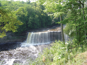
Clues: 1. A 200-square-kilometer state park shares the name of this waterfall, which cascades nearly 15 meters down and measures more than 60 meters across. At its maximum, a flow of more than 50,000 gallons of water per second has been recorded. This region has many waterfalls, due to harder Ordovician-aged dolomite overlying softer, eroded-away Cambrian-aged sandstones. 2. These “upper” falls are often called the root beer falls, due to the color of the water. The brownish water is caused by many different kinds of dissolved solids in the water, including organic materials such as tannic acids — the remains of the cedar, maple and hemlock forests surrounding the river. 3. Attracted by an abundance of fish and wildlife, including moose, deer and bears, natives lived along the shores long before lumberjacks settled the area in the late 1800s. During the thriving lumber industry, the river carried millions of logs to downstream lumber mills.
Name these falls and their location. Scroll down for the answer |
| Answer: Upper Tahquamenon Falls in Tahquamenon Falls State Park, near Paradise, Mich., in the Upper Peninsula, is often called Root Beer Falls because of the color of the water that flows down the Tahquamenon River. Upper Tahquamenon Falls is one of the largest waterfalls east of the Mississippi. Photo is by Brad Keelor. |
October
2006 Winners
Julie Angel (Champaign, Ill.)
Richard Bates (Baraboo, Wis.)
Claude Bolze (Sapulpa, Okla.)
Cheryl Carlton (Oakley, Mich.)
David Goldak (Andover, Kan.)
William Hansen (Marinette, Wis.)
Jack McCaw III (Lovington, N.M.)
Jeff Paetz (Westerville, Ohio)
Robby Tateo (Delmar, N.Y.)
Gabby Wusserzug (Glenmont, N.Y.)
September 2006
|
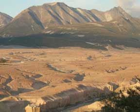
Clues: 1.Early in the 20th century, a National Geographic explorer named this remote and desolate volcanically formed valley for the many smoking fumaroles he saw. The valley no longer emits smoke and ash, but the name remains, as does evidence of a cataclysmic eruption several years prior to the explorer’s visit. 2.Dozens of earthquakes, some up to magnitude 7, preceded the eruption here that buried more than 100 square kilometers of previously lush greenery with ash and pumice up to 215 meters deep. 3. This valley is part of a national park, which today hosts more than a dozen active volcanoes, as well as the world’s largest population of protected brown bears.
Name this valley and its location. Scroll down for the answer |
| Answer: National Geographic explorer Robert Griggs named the Valley of Ten Thousand Smokes in Katmai National Park during a visit there following the 1912 eruption of Novarupta Volcano. The eruption buried 65 square kilometers (40 square miles) of lush green land beneath volcanic deposits up to 200 meters (700 feet) deep. Photo is by Ulli Limpitlaw. |
September
2006 Winners
David Bohaska (Port Republic, Md.)
James Elison (Bakersfield, Calif.)
Tony Limke (Cincinnati, Ohio)
Joyce Macbeth (Willow, Alaska)
Kenny Megginson (Petersburg, Va.)
Joe Scyphers (Bozeman, Mont.)
Richard Smith (Nathrop, Colo.)
Travis Stallings (Lancaster, Calif.)
Mike Sweet (Houston, Texas)
Ann Youberg (Tucson, Ariz.)
August 2006
|
Clues: 1.Part of a national park, a sulfur-rich lake rests in one of four craters found atop this peak, the country’s tallest active volcano, at more than 3,400 meters above sea level. 2.The volcano was named for both its noisy rumbling and its trembling, and has erupted multiple times over the last 300 years. A recent period of activity, ending a 20-year hiatus, began at the volcano on the day of a U.S. president’s official visit to the country and lasted for two years. 3. On a very clear day, two oceans reportedly may be visible from this volcano’s summit.
Name the volcano and its location. Scroll down for the answer |
| Answer: Volcán Irazú is the highest volcano in Costa Rica. Its most famous eruption began on March 19, 1963, the day U.S. President John F. Kennedy arrived in Costa Rica for a visit. Part of a national park, the volcano’s summit is a popular tourist spot, with a road leading to the top. Photo is by Sandy Colbert. |
August
2006 Winners
Anne Jefferson (Corvallis, Ore.)
Paula LaPoint (Chapel Hill, N.C.)
Cathy Lash (Santa Ana, Calif.)
Erin Martin (Browns Summit, N.C.)
Kenneth Nye (Marietta, Ga.)
David Pasta (Sugar Land, Texas)
John Reid (Fort Collins, Colo.)
C. Rooney (Butte, Mont.)
Sarah Swanson (Baker City, Ore.)
Jill Tarabula (Williamsville, N.Y.)
July 2006
|
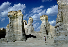
Clues: 1.In a region famed for its flatness and tornadoes, these spires and pinnacles appear to rise out of nowhere. Remnants of a Cretaceous-aged sea, these sedimentary “monuments,” which stand 21 meters high, formed through wind and water erosion and are held together by harder layers within the soft white rock. 2.The area is extremely rich in Cretaceous fossils, including swimming marine reptiles such as plesiosaurs and mosasaurs. 3. These formations are popular with tourists and geologists alike. They are the region’s first national natural landmark and are located on private property. Early pioneers used the monoliths as a landmark.
Name the site and location. Scroll down for the answer |
| Answer: Monument Rocks, also called Chalk Pyramids, is located in Gove County, Kan., and was the first landmark chosen by the Department of the Interior as a national natural landmark. Photo is by Jerome Wyckoff. |
July 2006 Winners
Ken Ferrone (Concord, Calif.)
William Gilliland (Topeka, Kan.)
Jerry Lineback (Lebanon, N.H.)
Ronald McDowell (Morgantown, W.V.)
Brian O’Neill (New Orleans, La.)
Joy Pochatila (Alexandria, Va.)
Karen Ritter (Wichita, Kan.)
Sofia Tangalos (Buffalo, N.Y.)
Bryan Tapp (Tulsa, Okla.)
Gregory Vandeberg (Grand Forks, N.D.)
June 2006
|
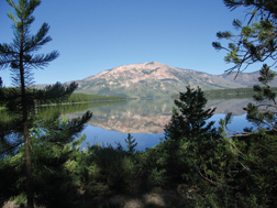
Clues: 1.This lake and mountain, located in the backcountry of an immensely popular national park, are only accessible via a 13-kilometer hike from a trailhead. The trails usually do not even open until mid-summer due to heavy bear activity. 2.The lake, either named after its shape or a local hunter who frequented the region in the 1800s, is a popular fishing destination. The mountain at 3,142 meters high, was originally named for the color of the volcanic rocks that form its slopes. That original name now applies to the entire mountain range encompassing this mountain, and this highest peak in the small range has been renamed. 3. A significant portion of this area burned almost two decades ago, so the hike to the mountain and lake offers a good look at nature in recovery.
Name the mountain and its location. Scroll down for the answer |
| Answer: In the backcountry of Yellowstone National Park, Heart Lake laps at the base of Mount Sheridan, which used to be known as Red Mountain. Photo is by Miriam Pinsker. |
June 2006 Winners
Erik Bachmann (Bozeman, Mont.)
Bob Czaja (Tucson, Ariz.)
Meagan DeRaps (Bozeman, Mont.)
Mark Duigan (Baltimore, Md.)
L. Duane Dungan (Cape Coral, Fla.)
Shaul Hurwitz (Menlo Park, Calif.)
Eloise Kendy (Helena, Mont.)
Tim Martin (Browns Summit, N.C.)
J. Brad Stephenson (Oak Ridge, Tenn.)
Kermit Witherbee (Shepherdstown, W.V.)
May 2006
|
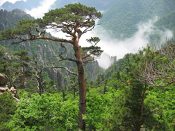
Clues: 1.Translated from its original native name into English, this mountain, one of the tallest in its home country, shares its name with a popular jewel. 2.The largely granitic mountain has weathered over time to create thousands of unique rock formations, including stone pillars, sharp cliffs and deep ravines. The 10,000-plus formations are thought to have cultural and spiritual significance for this region. The mountain also features deep ponds and waterfalls. 3. A major source of tourism for the region, with as many as 1 million people reported to have visited last year, this mountainous area will soon host a family resort complex, complete with an 18-hole golf course, skiing, several hotels and restaurants, as well as armed guards.
Name the mountain and its location. Scroll down for the answer |
| Answer: Kumgangsan, also known as Diamond Mountain, is the second tallest mountain in North Korea. The touristy area surrounding the mountain, complete with golf courses and a planned ski resort, is being developed by Hyundai Asan. More than 1 million people have visited the area since it opened to foreign tourists in 1998. Photo is by Ryan Serote and is courtesy of Katie Donnelly. |
May
2006 Winners
Christine Horner (Green Bay, Wis.)
Andrew McNeil (Buffalo, N.Y.)
David Pratt (Queensbury, N.Y.)
Charles Roll (Gansevoort, N.Y.)
Linda Weekes (Richland, Wash.)
Scott Williams (Florissant, Mo.)
Deb Ziegler (Hannibal, Mo.)
April 2006
|
Clues: 1.This mountain’s name is based on the color and type of rock that composes it. The small mountain range in which this mountain is located and the surrounding wilderness area also derive their names from the rock. 2.Volcanic, tectonic and glacial activity have extensively shaped the region in which this 2,100-meter-tall mountain is located. 3. The surrounding wilderness area, first set aside in 1931, is well-known among spelunkers for its numerous caves and among fishermen for its dozens of lakes chock-full of trout. Although some visitors to the area have reported sightings of Bigfoot, people are more likely to see black bears and deer.
Name the mountain and its location. Scroll down for the answer |
| Answer: Black Marble Mountain in Marble Mountain Wilderness Area is located in Klamath National Forest in Northern California. The area hosts one of the largest deposits of marble west of the Mississippi, and is a popular spelunking destination. Photo is courtesy of David Lindberg. |
April
2006 Winners
Barbara Anne am Ende (South Riding, Va.)
Jim Baichtal (Thorne Bay, Alaska)
Sandra Cannon (Oceanside, Calif.)
Matthew Mabey (Salem, Ore.)
Charles Roll (Gansevoort, N.Y.)
Beth Pratt-Situala (Ellensburg, Wash.)
Jeffrey Schaffer (Napa, Calif.)
David Weekes (Richland, Wash.)
Phil Woodward (Redding, Calif.)
David Ziegler (Hannibal, Mo.)
March 2006
|
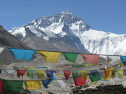
Clues: 1. This mountain is the tallest in its host mountain chain and is one of 14 mountains in the world taller than 8,000 meters. 2. The mountain has many layers of different rocks, beginning with metamorphic schist and gneiss at the base, which is topped by granite. The summit is composed of sedimentary rocks that are the remnants of an ancient sea dating back to 325 million years ago. 3. Despite its pristine look and remote location, some researchers estimate that in less than half a century, dozens of tons of glass, plastic and metal trash have been collected at this site. The host government began a cleanup plan in the 1990s, and has already removed several tons of trash.
Name the mountain. Scroll down for the answer |
| Answer: Mount Everest in the Himalayas is the world’s highest mountain, at about 8,850 meters (29,035 feet). In Tibet, the mountain is called Sagarmatha, and in Nepal, it is called Chomolungma. The mountain is still rising at a rate of about 2.5 centimeters per year. Photo is courtesy of Bob Carson. |
March 2006 Winners
Matteo Brestuglia (Perugia, Italy)
Jason Buck (Eureka, Calif.)
R. James Gauthier-Warinner (Chantilly, Va.)
Laxman Gurung (Berea, Ky.)
Alan Haight (Sunriver, Ore.)
Marilyn Hurst (Madison, Wis.)
Harvey Leifert (Washington, D.C.)
Pragnyadipta Sen (Manhattan, Kan.)
Rochelle Van Erem (De Pere, Wis.)
George Wallerstein (Seattle, Wash.)
February 2006
|
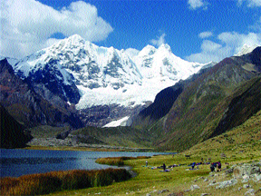
Clues: 1. A 12- to 15-day trek circumnavigates the 50-kilometer-long mountain range that is home to the glacially carved valley and moraine-blocked lake pictured here. Located in the northern part of the host country, the range is part of a much larger volcanic mountain range that runs the length of a continent. 2. Many peaks here have nearly vertical walls with overhanging ice, making them incredibly difficult to ascend. One of the highest peaks in this range was immortalized in a recent movie about two climbers’ perilous trek to the summit. 3. The name of this circuit trek and range means “weasel” (an indigenous animal of the region) in the local native language.
Name the range and location. Scroll down for the answer |
| Answer: The Cordillera Huayhuash in northern Peru, on Laguna Jahuacocha, is on the Huayhuash Circuit, a rough hike that circumnavigates the range. The circuit is a popular 12- to 15-day hike that people typically take with the help of donkeys. The photo is courtesy of John Garver. |
February
2006 Winners
Richard Bild (Albuquerque, N.M.)
Nick Burgess (Portland, Ore.)
Richard Ipri (West Point, N.Y.)
Karen Knuuti (Stockton Springs, Maine)
Venkat Peechara (Pearland, Texas)
Mike Stander (Ann Arbor, Mich.)
Amy Strobel (Purcellville, Va.)
Jerry Thompson (Marysville, Wash.)
Catherine Webster (Pryor, Okla.)
Debbie Ziegler (Hannibal, Mo.)
January 2006
|
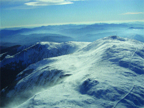
Clues: 1. At about 1,915 meters above sea level (just over a mile high), this mountain is one of the highest points along a famous and arduous hiking trail. It boasts some of Earth’s most severe weather, with an average temperature in July only reaching about 48 degrees Fahrenheit and record wind speeds topping 350 kilometers per hour. 2. The mountain shares its name with an early leader of the host country
— all of the 3. The mountain range began as sediments in a shallow sea several hundred
million years ago. The range was extensively shaped by glaciers during
the last ice age. Today, significant freeze-thaw fracturing continues
to break up the rocks in the range.
Name the mountain. Scroll down for the answer |
| Answer: Mount Washington tops the Presidential Range, which is part of the White Mountains in New Hampshire. The mountain holds the world record wind speed of 272 kilometers per hour, observed in April 1934. The Appalachian Trail traverses the entire Presidential Range. Photo is courtesy of Erik Williams. |
January
2006 Winners
James Carroll (Norwood, Mass.)
Nelia Dunbar (Socorro, N.M.)
Dean Dunn (Washington, D.C.)
Leonard Espinosa (Okemos, Mich.)
Michael Fontana (Livingston, N.J.)
Linda Lewis (Richardson, Texas)
Barbara Lloyd (Port Townsend, Wash.)
Gordon McKeague (Galena, Ill.)
Brenda Rutstein (New City, N.Y.)
Karl Wegmann (Bethlehem, Pa.)
2000: January February March April May June July August September October November December
2001: January February March April May June July August September October November December
2002: January February March April May June July August September October November December
2003: January February March April May June July August September October November December
2004: January February March April May June July August September October November December
2005: January February March April May June July August September October November December
2006: January February March April May June July August September October November December
2007: January February March April May June July August September October November December
2008: January February March April May June July August
