
|
 Subscribe

Where on Earth? Answer Archive
To submit an answer to the current Where
on Earth? click
here.
To offer photographs for Where
on Earth? send an E-mail message to earth@earthmagazine.org.
2001: January February March April May June July August September October November December
2002: January February March April May June July August September October November December
2003: January February March April May June July August September October November December
2004: January February March April May June July August September October November December
2005: January February March April May June July August September October November December
2006: January February March April May June July August September October November December
2007: January February March April May June July August September October November December
2008: January February March April May June July August
December 2005
|
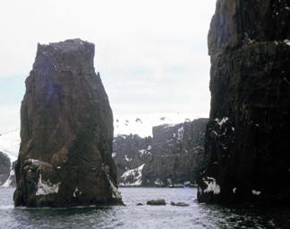
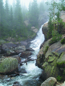
Clues: 1. This photo was taken in 1965, prior to a volcanic eruption that somewhat changed the surrounding landscape. This particular area, however, remains unique in shape and scope today — it marks the only entrance to an intermittently active, mostly submerged volcano. At one point along the channel, where it is less than 60 meters wide, the water is deep enough for a large ship to pass, leaving little room for error. 2. Early visitors named this feature after a wind-making device operated by the god of the seas, likely because of the sound of the wind whistling through the narrow channel. 3. Cruise ships often pass through this feature to reach the inner harbor
waters — the caldera — of this island, which are warm enough
for swimming despite being surrounded by near-freezing waters year-round.
Name this feature and its location. Scroll down for the answer |
| Answer: Neptunes Bellows is the 230-meter-wide entrance to Port Foster, the bay at the center of a volcanic caldera called Deception Island in the South Shetland Islands in Antarctica. The photo is courtesy of Carlos Frey. |
December
2005 Winners
Richard Berg (San Diego, Calif.)
Bob Carson (Walla Walla, Wash.)
Travis Cox (Arlington, Texas)
William Crawford (Bryn Mawr, Pa.)
Stephen Desrosiers (Fryeburg, Maine)
Joe Eastman (Athens, Ohio)
Lura Joseph (Mahomet, Ill.)
Bret Leslie (Vienna, Va.)
David Pratt (Queensbury, N.Y.)
John Schulenberg (Kerrville, Texas)
November 2005
|
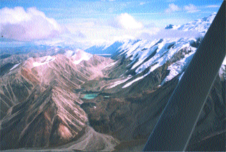
Clues: 1. This feature shares its name, which means “high one” in a native language, with a mountain and with a national park that is larger than the state of Massachusetts. The park and mountain, however, were first named after the host country’s former leader. 2. This feature stretches 2,100 kilometers and is a result of the collision of two tectonic plates. The two ridges on either side of the landform reflect different rock formations. 3. Bands of nomadic natives traversed the area for thousands of years,
with Caucasian settlers first visiting in the 1800s to prospect for gold.
Name the feature and its location. Scroll down for the answer |
| Answer: The Denali Fault system, as pictured here, runs 2,100 kilometers across Alaska and is one of the longest strike-slip fault systems in the world. On Nov. 3, 2002, a 7.9-magnitude earthquake shook the area and was felt as far away as Louisiana. Photo is courtesy of Elle S. Warloe. |
November
2005 Winners
Nancy Ferry (Edgewood, Wash.)
Evan Finkle (Delmar, N.Y.)
Kurt Hollocher (Schnectady, N.Y.)
Andrew Kerr (Golden, Colo.)
Carla Montgomery (DeKalb, Ill.)
Alan Powers (Anchorage, Alaska)
Timothy Shevlin (Pittsburgh, Pa.)
Patti Sutch (Mountain View, Calif.)
Mike Sweet (Houston, Texas)
Ryan Twomey (Slingerlands, N.Y.)
October 2005
|
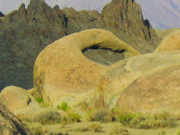
Clues: 1. These outcrops are the well-weathered remains of a metamorphosed volcanic rock about 150 to 200 million years old and a granitic rock about 90 million years old. The rock formations lie at the base of one sculptured mountain chain and in the shadow of another; the valley is visibly scarred by a strong earthquake that rocked the area in the 1870s. 2. This area has been the backdrop for many famous Western movies as well as television commercials. One of the roads in the area is even known as “Movie Road.” 3. Prospectors sympathetic to the losing side of a civil war named the area after an important warship that wreaked havoc on supply ships from the victorious side. Miners who sympathized with the winning side of the war then named several nearby features after the ship that sank the warship.
Name this location. Scroll down for the answer |
| Answer: The Alabama Hills in Southern California form the gateway to the Sierra Nevada and to Mount Whitney, the highest point in the range. The well-weathered boulders of the Alabama Hills sharply contrast with the rugged Sierras. Photo by Heather Brown. |
October 2005 Winners
Walter Borowski (Richmond, Ky.)
John Harper (Pittsburgh, Pa.)
Alec Hrynyshyn (Orem, Utah)
Howard Level (Ventura, Calif.)
Bob Niblack (Rocklin, Calif.)
Katrina Pekar (Manhattan, Kan.)
Bobby Rasband (Temecula, Calif.)
Jeff Ritchie (Wichita Falls, Texas)
David Sams (Sunol, Calif.)
Robin White (Placitas, N.M.)
September 2005
|
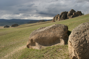
Clues: 1. This national park, created in 1993, is one of the most visited sites in the host country. Popular activities include hiking and horseback riding in the summer and dogsled racing in the winter, when temperatures can reach well below zero. 2. The park is best known for its stark glacially carved granite rock formations, craggy pine-covered mountains, and expansive grasslands filled with rhododendron and edelweiss in the summertime. 3. The park abuts a mountain range and protected area that is almost
completely uninhabited by humans, but is home to several endangered species,
including moose, bears and weasels. The protected area is believed to
be the birthplace of a legendary nomadic warrior from the 13th century.
Name the park. Scroll down for the answer |
| Answer: Gorkhi-Terelj National Park in Mongolia is about 80 kilometers from Ulaanbaatar, Mongolia’s capital city, and is a popular tourist destination. The park lies on the edge of the Khentii Mountains, where Genghis Khan allegedly was born. Photo is by Wayne Ostlie. |
September 2005
Winners
Hossein Ahvari (Newport Beach, Calif.)
Ashley Archer (Russellville, Ark.)
Dan Barth (Glenmont, N.Y.)
Les Beard (Oak Ridge, Tenn.)
Richard Blank (Spokane, Wash.)
Silvana Denza (The Woodlands, Texas)
Lisa Fisher (Golden, Colo.)
Edward Grew (Orono, Maine)
Kyle Niehaus (Glenmont, N.Y.)
Deborah Peoples (Delaware, Ohio)
August 2005
|
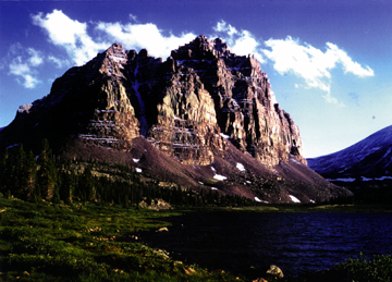
Clues: 1. This 4,000-meter-tall mountain, named for its distinctive color and turreted architectural form, is carved from Proterozoic quartzite that was buried by an ancient sea and then thrust up again. During the last ice age, the area was extensively shaped by glaciers, which left behind hundreds of lakes, including the one in the foreground that shares the name of the mountain. 2. The mountain range that surrounds this feature runs east to west more than 200 kilometers, and is a popular backpacking area. From a parking area at the end of a long, unpaved forest road, a rugged 15-kilometer trail leads up to the lake and base of the mountain. 3. Some of the best dinosaur fossil hunting opportunities in the host country are nearby.
Name the location. Scroll down for the answer |
| Answer: Red Castle Mountain, and Red Castle Lake in its shadow, are located in the Uinta Mountains, which run 200 kilometers east-west across northern Utah. Photo is courtesy of Wallace R. Hansen. |
August 2005 Winners
Mike Antolik (Cocoa Beach, Fla.)
Geoff Bedell (Oakley, Utah)
Jan Callister (Draper, Utah)
Jerry Dolence (Reno, Nev.)
Diane Doser (El Paso, Texas)
Jim Ferguson (Nashville, Ind.)
John Garver (Schenectady, N.Y.)
John Keith (Sterling, Va.)
Robert Rogers (Evergreen, Colo.)
Jim Sukup (Carmel, Ind.)
July 2005
|
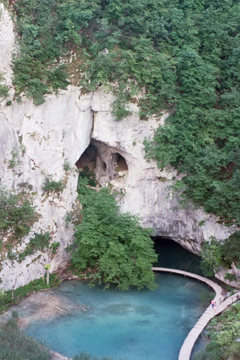
Clues: 1. The term karst came from this part of the world, which is known for its incredible Mesozoic-aged limestone and dolomite sinkholes and caves. Half of the topography of the host country is karst. 2. This park boasts cascading waterfalls up to 80 meters tall and many interconnected lakes. Through a symbiotic relationship, calcite-producing algae create dams and barriers between the lakes made of travertine, a precipitated mineral. 3.The location is a UNESCO World Heritage Site and is the host country’s
first national park, declared in the mid-20th century.
Name the park. Scroll down for the answer |
| Answer: Plitvice Lakes National Park (Plitvicka Jezera) is located in Croatia. The park is known for its travertine dams and barriers that create spectacular waterfalls and an abundance of lakes. Photo courtesy of Ksenija Namjesnik-Dejanovic. |
July
2005 Winners
Antonio Arribas (Reno, Nev.)
Shannon Bell (Fredericksburg, Va.)
Scott Coles (Ashland, Wis.)
Sandy Deiber (Carol Stream, Ill.)
Alejandro Franco (The Woodlands, Texas)
Sandee C. La Boda (Kelso, Wash.)
Nancy Rorick (Sandy, Ore.)
Michael Rowe (Corvallis, Ore.)
Julie Urban (Brookfield, Wis.)
June 2005
|
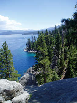
Clues: 1. The area is composed almost entirely of a massive salt-and-pepper-colored granite batholith, underlain by active faults. Huge granite slabs line the many hiking trails in the area. 2. This location is the only place that ever freezes over within the larger body of water and was named because of its gem-like color. More than 60 streams flow into the larger body of water but only one flows out. 3. This bay contains the only island to be found in the more than 190-square-mile water-filled basin. The island is a 150-foot-high granite upthrust, topped by sparse vegetation and remains of a stone structure carried out to the island in the 1920s.
Name the location. Scroll down for the answer |
| Answer: Emerald Bay on the western side of Lake Tahoe is a National Natural Landmark and a California State Park. The glacially carved turquoise bay is surrounded by granite cliffs. Fannette Island, located in the bay, is the only island in Lake Tahoe. Photo by Megan Sever. |
June 2005 Winners
Richard Cohoon (Russelville, Ark.)
Fred DeWiel (Calgary, Alberta)
David Gius (Dixon, Calif.)
Pamela Gore (Decatur, Ga.)
Don Lindsay (Bakersfield, Calif.)
Karen Locke (Santa Clara, Calif.)
Larry OBrien (Middletown, N.Y.)
Steve Sittler (Granger, Ind.)
Michael Starbuck (Rolla, Mo.)
Dana Willis (Winnemucca, Nev.)
May 2005
|
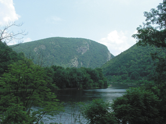
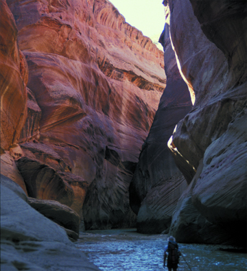
Clues: 1. The main rock formation in this area, of Silurian age, is full of pure quartz, making it highly resistant to erosion. Nonetheless, the deep mountain pass pictured here was carved out of a flat river plain over the past several million years by one of the few remaining undammed rivers in the region. It is one of many ravines formed by wind or water in the high ridges of a long mountain chain. 2. During the most recent ice age, glaciers reached just south of this area and have left behind telltale signs. 3. The park surrounding this ravine is more than 109 square miles and offers outdoor recreational opportunities, including hiking, canoeing and kayaking. Visitors will see remnants of past inhabitants: from native campsites and colonial homesteads to copper mines that were active as recently as the early 1900s.
Name the feature. Scroll down for the answer |
| Answer: The Delaware Water Gap National Recreation Area spans the border between Pennsylvania and New Jersey. Travelers along U.S. Route 209 pass through this spot. Image courtesy of Donald Smith. |
May 2005
Winners
Jeremy Apgar (Wantage, N.J.)
Steve Dutch (Green Bay, Wis.)
Tom Hawisher (Savoy, Ill.)
Charles Hutchinson (Tucson, Ariz.)
Hugh Rance (Flushing, N.Y.)
Bruce Sloane (Sperryville, Va.)
Daniel Snare (Golden, Colo.)
David Speidel (Forest Hills, N.Y.)
Liane Stevens (Waltham, Mass.)
Jeanne Thibeault (Spencer, Mass.)
April 2005
|
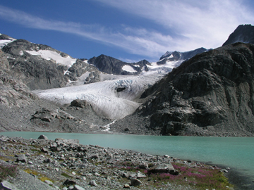
Clues: 1. This glacial lake is surrounded by two shrinking glaciers, one that shares the name of the lake and one that sounds like something that would appear in a house, rather than in nature. 2. In the mid-1800s, a British surveyor named a dominating volcanic mountain peak in the park after a famous 19th century Italian soldier; the park now shares the name with the peak. 3. The main hiking trail leading up to this lake ascends 1,200 meters (almost 4,000 feet) over 7 kilometers (about 4.4 miles), and passes a 300-meter-high (nearly 1,000-foot-high) waterfall along the way. Legend has it that loggers and fishermen created the trail hundreds of years ago.
Name the lake and park. Scroll down for the answer |
| Answer: Wedgemount Lake in Garibaldi Provincial Park in British Columbia is surrounded by the Wedgemount and Armchair glaciers. It is a popular hiking destination, with a 7-kilometer-long trail that climbs 1,200 meters and takes four to six hours each way. Photo by Naomi Lubick. |
April 2005
Winners
Brian Cooper (Huntsville, Texas)
Ben Haravitch (Hemlock, N.Y.)
Jim Jackson (Portland, Ore.)
Anne Jefferson (Corvallis, Ore.)
Bob Kahn (Falls Church, Va.)
Hannah Meckler (Delmar, N.Y.)
Rose Pool (Corpus Christi, Texas)
Norman Smith (Lincoln, Neb.)
Jeff Spooner (Rolla, Mo.)
Ken Sprenke (Moscow, Idaho)
March 2005
|
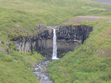
Clues: 1. This waterfall is the most popular attraction in the second oldest national park in the host country. The national park used to be a manor farm, and the estate was later owned by a church and then royalty. Ruins of a farmhouse still remain in the park. 2. The river and waterfall cut through broad columns of basalt, which can be seen surrounding the falls in the shape of an ampitheater. It is from the basalt that the waterfall gets its name, not the color of the water. 3. An overlook on the main trail to the waterfall offers broad views of an outwash plain that has evidence of many glacial floods caused by volcanic activity.
Name the waterfall and its location. Scroll down for the answer |
| Answer: Svartifoss Falls, also known as “black waterfall” for the large columns of basalt behind and flanking the falls, is located in Skaftafell National Park in southern Iceland. Skaftafell was a manor farm and local assembly site in the Middle Ages, and the farmhouse still remains. Photo by Peter Gill. |
March 2005
Winners
Karen Berry (Wheat Ridge, Colo.)
Christine Bevc (Boulder, Colo.)
Peter Forman (Altamont, N.Y.)
Julian Gray (Marietta, Ga.)
Paul Hoskin (Ellensburg, Wash.)
Eloise Kendy (Helena, Mont.)
Joshua Rosenfeld (Granbury, Texas)
Scott Salentine (Wauwatosa, Wis.)
Richie Williams (West Falmouth, Mass.)
James Zambito (Buffalo, N.Y.)
February 2005
|
Clues: 1. This feature bears a characteristic that John W. Powell recognized in the early 20th century: a gap in the rock record between ancient granite and overlying sandstone. 2. This feature takes its name from a native word for a vibrant-colored fruit. 3. The world’s longest cable tram runs up the side of this mountain to a total elevation higher than 10,000 feet. In the 40 years the tram has been running, it has carried more than 8 million people to the peak and back.the feature and its location.
Name the feature and its location. Scroll down for the answer |
| Answer: The Great Unconformity at Sandia Peak near Albuquerque, N.M., is where approximately 300-million-year-old limestone and sandstone directly overlay 1.8-billion-year-old granites. “Sandía” is Spanish for “watermelon” and may refer to the mountains’ pink hue at sunset. Photo by Lisa Pinsker. |
February
2005 Winners
John Bahl (Baltimore, Md.)
Alicia Dekle (Albuquerque, N.M.)
G. Thomas Farmer (Las Cruces, N.M.)
Devinne Funk (Fort Edward, N.Y.)
John Keller (Denver, Colo.)
Richard Lozinsky (Fullerton, Calif.)
Tim Martin (Greensboro, N.C.)
Bob Mozer (Remsenburg, N.Y.)
Karin Rice (Long Beach, Calif.)
Scott Tinker (Austin, Texas)
January 2005
|
Clues: 1. In the 1960s, this landslide raged into an artificial lake behind
a new hydroelectric dam, creating a tidal wave that wiped out several
towns and killed more than 2,000 people. A movie was made about the landslide. 3. The oldest human settlements in this region date to 7000 B.C. Many
different empires have ruled this region at one time or another, leaving
a multicultural environment behind. Name the landslide and location. Scroll down for the answer |
| Answer: The Vajont (or Vaiont) landslide occurred off Mount Toc in the Dolomite Mountains of Northern Italy on Oct. 9, 1963. The mountainside collapsed into the reservoir behind the new Vajont Dam, displacing water that then surged over the dam and flooded villages in the valleys downstream. Photo is courtesy of Matteo Brestuglia. |
January 2005 Winners
Carlos Albrizzio (Encinitas, Calif.)
Anne Argast (Fort Wayne, Ind.)
Daniel Bernoulli (Basel, Switzerland)
Mark Chen (Oklahoma City, Okla.)
Kaushal Desai (Springfield, Ill.)
Gina Iwahashi (Sacramento, Calif.)
Sid Perkins (Washington, D.C.)
William Robinson (Lubbock, Texas)
Mike Tuohy (Buford, Ga.)
Kimo Zaiger (Somis, Calif.)
December 2004
|
Clues: 1. The area surrounding this 25-foot-high waterfall has undergone multiple mountain-building events. The falls erode the granite that intruded into this national park’s predominately metamorphic (slate, schist and gneiss) mountain range following the first building event. 2. During the Cretaceous and Jurassic, dinosaurs roamed this area, which was then a balmy tropical wetland. During the last several ice ages, glaciers filled the mountain valleys, leaving behind a creek flowing into these provincially named falls. 3. Weather changes frequently in the park. Sunny summer mornings often give way to fierce afternoon thunderstorms. This picture was taken in August. That afternoon, a snowstorm struck high on a nearby peak popular with hikers.
Name the feature and location. Scroll down for the answer |
| Answer: Alberta Falls in Rocky Mountain National Park is one of the most popular tourist attractions in the park, as it is an easy hike from the Glacier Gorge Junction Trailhead. Photo courtesy of Ehren Rudolph. |
December 2004
Winners
Kirby Cockerham (Greenwood Village, Colo.)
Silvana Denza (The Woodlands, Texas)
Ken Finger (Berkeley, Calif.)
Lawrence Gilbert (Dayton, Ohio)
Jim Kirchner (Tawas City, Mich.)
David McMullin (Wolfville, Nova Scotia)
William Pegram (Arlington, Mass.)
Charles Roll (Gansevoort, N.Y.)
Donald Schwert (Fargo, N.D.)
Adam Tschida (Boulder, Colo.)
November 2004
|
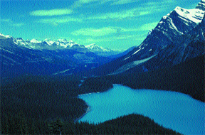
Clues: 1.This natural lake lies within one of the oldest national parks in the
world. The town that shares the same name as the park sprung up after
discovery of nearby hot springs. 3. The area’s annual temperatures range from 30 degrees Celsius
in the summer to negative 30 degrees Celsius in the winter. Name this lake and its location. Scroll down for the answer |
| Answer: Peyto Lake is in Banff National Park, which is Canada's oldest national park and is bounded on the west by several hundred miles of the Continental Divide. An argument over the ownership of nearby hot springs led to the protection and development of Banff National Park in the late 1880s. Photo courtesy of Edith Chasen. |
November 2004 Winners
Bob Fleischer (Schenectady, N.Y.)
Ken Fulton (Aberdeen, Ohio)
Kenneth Markwell (St. Joseph, Mo.)
Nancy Piltch (Olmsted Falls, Ohio)
John Reid (Fort Collins, Colo.)
Andy Ritter (Williams, Ind.)
Norman Smith (Lincoln, Neb.)
Brad Stevenson (Oak Ridge, Tenn.)
Catherine Webster (Pryor, Okla.)
Jeff Wilson (Santa Monica, Calif.)
October 2004
|
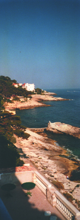
Clues: 1. Between one of the world’s highest mountain chains and a sea, this narrow region extends through three countries in just a few kilometers. 2. The average annual temperature is 16 degrees Celsius, with rain falling on average fewer than 60 days per year, and the sun shining 7 hours per day. 3. Blood-red sandstone cliffs are famous throughout, but in the area’s native language, the region is actually named for the stunning color of its water.
Name the region. Scroll down for the answer |
| Answer: A beach at Cap d’Ail in France is part of the Côte d’Azure, or the Riviera, which is a narrow strip of land between the Alps and the Mediterranean. The Riviera encompasses bits of France, Italy and all of Monaco. Photo by Catherine Rudolph. |
October
2004 Winners
1. William Smith (McLean, Va.)
2. Louise Berryhill (Marietta, Ga.)
3. Harry Siebert (Dolores, Colo.)
4. Ben LeFebvre (San Francisco, Calif.)
5. Don Lindsay (Bakersfield, Calif.)
6. Wesley Krawiec (Saltsburg, Pa.)
7. Andrew Alden (Oakland, Calif.)
8. Rainer Schaefer (Jülich, Germany)
9. Mary Ann Czechowski (Doylestown, Pa.)
10. Daniel Malloy (Everett, Mass.)
September 2004
|
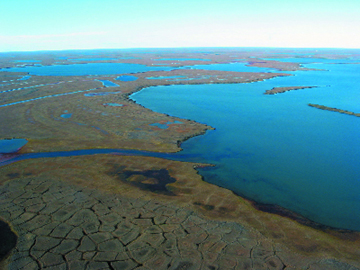
Clues: 1.This lake is part of the largest block of publicly owned land in its
host country, and is home to nesting habitats for thousands of loons,
ducks, geese and swans, as well as a large mammalian herd. 3. In a native tongue, the name of this lake refers to its considerable
size. Name this lake and its location. Scroll down for the answer |
| Answer: Teshekpuk Lake is located on Alaska’s North Slope in the National Petroleum Reserve-Alaska. “Teshekpuk” means “the largest lake of all” in the native Inupiat tongue. This vast network of wetlands provides calving grounds for caribou as well as homes for numerous birds. Photo courtesy of the Bureau of Land Management, Alaska. |
September 2004 Winners
1. Jerry Brown (Woods Hole, Mass.)
2. R. Morgan Button (Cincinnati, Ohio)
3. Helen Delano (Middletown, Pa.)
4. John Gallway (Menlo Park, Calif.)
5. David Lindberg (Eureka, Calif.)
6. Mike Mitchell (Anchorage, Alaska)
7. David Munoz (McKinleyville, Calif.)
8. Rick Saltus (Denver, Colo.)
9. David Stanley (Anchorage, Alaska)
10. David Swanson (Baker City, Ore.)
August 2004
|
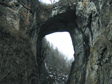
Clues: 1. This limestone feature is a remnant of an extensive karst system. The collapse of a great cavern, excavated by an underground stream, led to its isolation. 2. This feature and the surrounding land (more than 150 acres) were privately bought in 1774 for what would today be $19. It remains privately owned to this day and is not far from mountainous wine country. 3. Herman Melville refers directly to this feature in Moby Dick, comparing it to the great white whale as it leaps from the water.
Name this feature and location. Scroll down for the answer |
| Answer: Natural Bridge in Virginia is a limestone arch located near Lexington, Va. Surveyed by George Washington and once owned by Thomas Jefferson, it now has a major road (Route 11) running over it. Photo courtesy of Lisa Pinsker. |
August 2004 Winners
1. Donald Smith (Sparta, N.J.)
2. Angela Cross (Virginia Beach, Va.)
3. Bob Carson (Walla Walla, Wash.)
4. Katie Weller (Alexandria, Va.)
5. James Head (Providence, R.I.)
6. Verle Emanuelson (Bernville, Pa.)
7. Brendan Cox (Centreville, Va.)
8. Sandra Colbert (St. Petersburg, Fla.)
9. Anne Lutz (Harrisburg, Pa.)
10. Carol Peterson (Virginia Beach, Va.)
July 2004
|
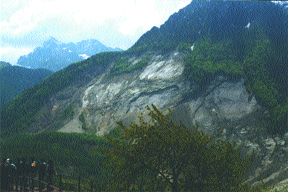
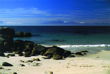
Clues: 1.Charles Darwin first described the 600-million-year-old granite pictured
in the foreground. The granite, intruded by dolerite dikes, is mined for
kaolin, which is used locally for making china and paper. 3. The area is well-known for its storms and rough seas, which legends say are caused by a mythical giant that is angry about the loss of a love. Since a Portuguese explorer first sailed to this location in the 15th century, the seas have claimed more than 25 large ships. Name this location. Scroll down for the answer |
| Answer: Froggy Pond, a renowned diving spot, is part of False Bay near the Cape of Good Hope and Cape Town, South Africa. The Cape granite is on the beach in the foreground, with the Hottentot Mountains in the background. Photo courtesy of Jay Gregg. |
July
2004
Winners
1. Peter McCorquodale (Berkeley, Calif.)
2. Jacqueline Shea (Pittsburgh, Pa.)
3. Elizabeth Pegram (Arlington, Mass.)
4. Martin Jackson (Austin, Texas)
5. Mike Wilson (Irene, South Africa)
6. Ryan Bennett (Springfield, Ill.)
7. Richard Hunter (Houston, Texas)
8. Tom Hawisher (Savoy, Ill.)
9. Richard Smith (Nathrop, Colo.)
10. Linda Lewis (Richardson, Texas)
June 2004
|
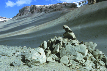
Clues: 1. The dominant rock in this location is granodiorite gneiss, and the capstone layer on the mountains is dolerite. The vertical relief in the picture is about 700 meters. 2. Discovered in the early 20th century, this site was thought lifeless until the late 1970s. 3. No rain has been recorded in this Mars-like landscape over the past 2 million years. A salty lake in this location shares its name with a famed Casanova. Name this location. Scroll down for the answer |
| Answer: Wright Valley is one of Antarctica’s McMurdo Dry Valleys. It is located in the Transantarctic Mountains and hosts Don Juan Pond, the world’s saltiest lake. Photo courtesy of Kurt Cuffey. |
June
2004
Winners
1. Michael Starbuck (Rolla, Mo.)
2. Robert L. Edwards (Boulder, Colo.)
3. Julie Palais (Arlington, Va.)
4. Bruce Malfait (Alexandria, Va.)
5. Charles C. Plummer (Sacramento, Calif.)
6. Charles R. Bentley (Madison, Wis.)
7. Linda Hansen (Arlington, Mass.)
8. Jonathan Berg (DeKalb, Ill.)
9. Richard E.A. Ipri (West Point, N.Y.)
10. Donald Schwert (Fargo, N.D.)
May 2004
|
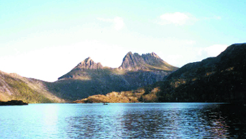
Clues: 1. Huge dolerite sheets covering this site mark a tug-of-war between two plates during the breakup of Gondwana. 2. Part of a world heritage wilderness area, the site boasts many hiking trails — going through temperate rainforests, quartzite beaches, glacial lakes and subalpine fields. The host island is famed for a nocturnal, terrier-sized whirlwind of a creature. 3. This feature was named in the early 19th century for a type of bed. Name this site and location.
Scroll down for the answer |
| Answer: Cradle Mountain in Cradle Mountain/Lake St. Clair National Park in Tasmania. Photo courtesy of Kimmo Kosonen. |
May 2004 Winners
1. Alan Marshall (Nedlands, Western Australia)
2. Christian Cicimurri (Clemson, S.C.)
3. Paula Stine (Decatur, Ill.)
4. Jay Smerekanicz (Manchester, N.H.)
5. Dick Jackson (Austin, Texas)
6. Curt Frischkorn (Santa Fe, N.M.)
7. Jason Buck (Eureka, Calif.)
8. Thomas Laudon (Oshkosh, Wis.)
9. O. Kelly Murphy (Long Beach, Calif.)
10. Les Beard (Oak Ridge, Tenn.)
April 2004
|
Clues: 1. Seven different geologic sandstone formations mark this feature, revealing
200 million years of geologic history. Large crossbeds exhibit colorful
banding in yellow, orange, pink and red caused by the precipitation of
manganese, iron and other oxides. 2. The silt-laden river that has sculpted this feature is named for a native word meaning “muddy water,” referring to the frequent flash floods during which tributaries run reddish-orange. 3. Ancient petroglyphs, campsites and ruins indicate that early people traveled here more than 700 years ago. In more recent times, the feature has served as a backdrop to many movies, including one about an infamous outlaw. Name the feature and its location. Scroll down for the answer |
| Answer: Paria Canyon in Utah and Arizona. Photo submitted by Keith Meldahl. |
April 2004 Winners
1. Kenneth Nye (Lawrenceville, Ga.)
2. Gil Mull (Santa Fe, N.M.)
3. Sandra Cannon (Oceanside, Calif.)
4. Stanton Cox (Clements, Calif.)
5. Art Johnson (Kenner, La.)
6. Thomas McGuire (Cave Creek, Ariz.)
7. Edith Chasen (Woodhaven, N.Y.)
8. Charlie Roll (Gansevoort, N.Y.)
9. Richard Smith (Nathrop, Colo.)
10. Lisa Rossbacher (Marietta, Ga.)
March 2004
|
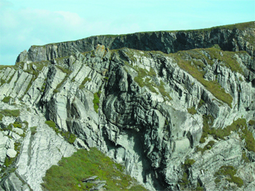
Clues: 2. Viewed from the bridge, this feature is found in a pervasive sandstone unit of Devonian age that is somewhat misleading in nomenclature. 3. The feature hosts a 100-year-old lighthouse that is rumored to be the last light seen by the Titanic.
Name the feature and its location.
Scroll down for the answer |
| Answer: Mizen Head, County Cork, Ireland; Photo by Ken Franklin, Phoenix, Ariz., and courtesy of RJ Gauthier-Warinner in Arlington, Va. |
March 2004 Winners
1. Bryan Huff (Champaign, Ill.)2. Mindi Snoparsky (Philadelphia, Pa.)
3. Michael Summers (Petersburg, Ill.)
4. Sandra Cannon (Oceanside, Calif.)
5. Charles Roll (Gansevoort, N.Y.)
6. Paul Black (Albany, Calif.)
7. Charles Sprague (Richardson, Texas)
8. Sean O’Connor (Medford, Mass.)
9. David McMullin (Wolfville, Nova Scotia)
10. Michael Barton (Bozeman, Mont.)
February 2004
|
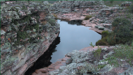
Clues: 2. The waterfall’s name comes from the metal that gives the stratigraphic rocks a pinkish hue. The metal thus hints at the presence of oxygen when these Mesoproterozoic rocks deposited. 3. The park is located in a country well-known for its mineral and agricultural resources. Recently, the country has been a formidable negotiator affecting conditions for U.S.-led efforts to create a free trade zone in the Americas.
Name the national park. Scroll down for the answer |
| Answer: Chapada Diamantina in Bahia State, Brazil. Photo by Kristina Brody. |
February 2004 Winners
1. Andrew Alden (Oakland, Calif.)
2. Brett Bersche (Springfield, Ill.)
3. Marcelo A. T. de Oliveira (Florianópolis, Brazil)
4. Jerry Dolence (Reno, Nev.)
5. Milton Fonseca (Sacramento, Calif.)
6. John A. Harper (Pittsburgh, Pa.)
7. Kimmo Kosonen (Kammenniemi, Finland)
8. Peter McCorquodale (Berkeley, Calif.)
9. Mary Ohren (Portola, Calif.)
10. Ann Proske (Lubbock, Texas)
January 2004
|
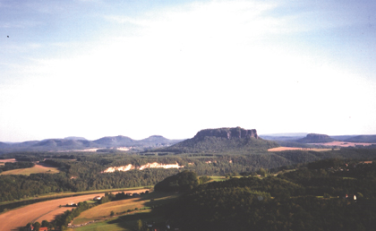
Clues: 2. Cretaceous seas left behind the sandstone that makes up these cliffs, which are now part of a national park. The same sandstone was used to build a famous gate located in this country's current capital city. 3. The bombing of a nearby city inspired a 1969 novel that was turned into a movie in 1972.
Name the park and the region. Scroll down for the answer |
| Answer: Both the park and the region are known as Saxon Switzerland (Sächsische Schweiz), which is located in Germany just southeast of Dresden (the firebombing of which in February 1945 killed over 130,000 people and was the subject of Kurt Vonnegut's Slaughterhouse 5) on the border with the Czech Republic. The gate built of the Elbe sandstone is the Brandenburger Tor, symbol of German reunification in 1989. |
January 2004 Winners
1. J. Marc Coolen (Hagerhill, Ky.)
2. Scott P. Cooper (Albuquerque, N.M.)
3. Candy Martinez (Fremont, Calif.)
4. William J. Pegram (Arlington, Mass.)
5. Daniel Phelps (Lexington, Ky.)
6. Christina Poulos (Binghamton, N.Y.)
7. Chris Scott (Brentwood, Tenn.)
8. Adam Smith (Summershade, Ky.)
9. Norman D. Smith (Lincoln, Neb.)
10. Rebecca Widing (Barre, Mass.)
2000: January February March April May June July August September October November December
2001: January February March April May June July August September October November December
2002: January February March April May June July August September October November December
2003: January February March April May June July August September October November December
2004: January February March April May June July August September October November December
2005: January February March April May June July August September October November December
2006: January February March April May June July August September October November December
2007: January February March April May June July August September October November December
2008: January February March April May June July August
