
|
Geophenomena Rumbles in Indonesia Mount St. Helens rising Rumbles in Indonesia
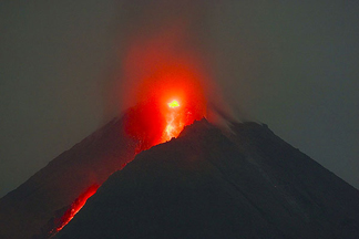
Lava flowed down the slopes of Indonesia’s Mount Merapi, one of the world’s most active volcanoes, on May 27, just one hour before a damaging earthquake would strike the nearby district of Bantul, killing thousands of people. Photograph is by Tom Pfeiffer/www.VolcanoDiscovery.com. The country’s volcanologists have kept a close watch on restless Mount Merapi for the past five years — a period of unusual quiet for the volcano, which has historically rumbled into life every one to two years, says geologist John Pallister of the joint U.S. Geological Survey (USGS)-USAID Volcano Disaster Assistance Program. Last August, Indonesian scientists at nearby Yogyakarta’s Volcano Technology Development and Education Agency, located 30 kilometers south of the volcano, noted increased seismic activity at the volcano. Activity increased again in April, followed by thick white sulfur dioxide smoke that billowed 400 meters into the air, accompanied by streams of lava flowing down the mountain’s sides. By May, a glowing dome of lava rapidly growing at the volcano’s peak indicated the type of eruption that might come: Instead of a single massive explosion, the dome could collapse, sending searingly hot ash and steam clouds known as pyroclastic flows speeding down the volcano’s flanks. This type of eruption is typical of this volcano, so much so that it is known as a “Merapi style of volcanism,” says geologist Jim Vallance of the USGS Cascades Volcano Observatory in Vancouver, Wash. “The good news is [these types of eruptions] don’t produce the widespread damage of more explosive events,” Pallister says. “But the focused impacts are deadly.” During the volcano’s most recent major eruption in 1994, for example, the flows reached temperatures of up to 600 degrees Celsius and sped down the mountain at more than 100 kilometers per hour, killing 66 people. Merapi’s deadliest recorded eruption occurred in 1930, killing 1,369 people. Many of the Javanese people living on Mount Merapi’s fertile slopes, however, were skeptical of the volcano’s danger. From May until June, the volcano, looming more than 2,900 meters above central Indonesia, continued to send both lava and the pyroclastic flows, locally called wedhus gembel or “shaggy goats,” down its slopes. Authorities have most feared a large-scale collapse of the dome at the summit, which could feed larger flows that might sweep into more populous villages, Pallister says. That concern prompted Indonesian scientists to raise the danger alert to its highest level in May, leading to mandatory evacuations of 22,000 villagers within a hazard zone extending to about 12 kilometers from the summit. After the dome partially collapsed on June 9, relieving some of the pressure, authorities dropped the alert level one notch — only to raise it again June 14 as the volcano erupted another series of pyroclastic flows, the first to reach as far as the volcano’s closest villages. Many villagers, who had begun to return home, fled again. Also complicating monitoring efforts at Merapi has been recent seismic activity. On May 26, a magnitude-6.3 earthquake struck nearby Bantul, leaving about 5,700 people dead, thousands more injured and 200,000 homeless. Although the ultimate source of both seismic and volcanic activity in Indonesia is the same — the Indo-Australian plate diving underneath the overlying Eurasian plate — researchers are unsure how closely the Bantul earthquake and Merapi eruption are connected, or how the two events might interact. The earthquake’s epicenter was just southwest of Yogyakarta, close enough to Merapi that some scientists feared that the tectonic activity might trigger a collapse of the volcano’s lava dome, or was an indication of an imminent major eruption. Indeed, seismologists monitoring Merapi have noted a higher frequency of heat clouds at the volcano since the quake, including the June 6 event, which sent pyroclastic flows up to 2.5 kilometers from the summit. “It’s really hard to define, because the earthquake occurred close enough to the volcano that there may be some kind of causal link between the two,” says Jim Dewey, a geologist at the USGS Earthquake Hazards Program in Denver, Colo. Earthquakes can precede eruptions, but rising magma can also trigger earthquakes, he says. “Historically, there’s just no clear pattern that enables us to sort that out.” Carolyn Gramling Links: Mount St. Helens rising
Before part of it collapsed on May 12, this fan-shaped slab of volcanic rock, shown here on May 9, reached a height of about 100 meters (300 feet) within Mount St. Helens’ crater. Photograph is by Dan Dzurisin, Cascades Volcano Observatory, USGS . On May 12, however, the formation — already close to 100 meters high and 100 meters wide — became unstable and partially collapsed, losing about two-thirds of itself in the rockfall, says Larry Mastin, a geologist at the U.S. Geological Survey’s Cascades Volcano Observatory in Vancouver, Wash. On May 29, a magnitude-3.1 earthquake coincided with a second large rockfall, followed by a plume of steam and ash shooting up to 6,000 meters (20,000 feet) into the air. What’s left, Mastin says, is a “small, tooth-shaped remnant of the old fin,” mostly covered with dark dust and debris. “But we can see, visibly, that it’s still growing,” he says. And with less weight holding it down, the formation’s growth rate has probably accelerated since its collapse, pushed insistently upward by a continuous supply of lava from within the volcano. The growing rock is the seventh formation to appear in the crater since September 2004, when low-level seismic activity signaled that the mountain was reawakening. Although the rock fin and other formations show that Mount St. Helens is far from dormant, scientists do not take them as signs of an imminent explosive eruption, akin to the 1980 blast that killed 57 people and blew the side off the mountain. Compared with Indonesia’s currently rumbling Mount Merapi (see story above), the emerging lava at Mount St. Helens’ dome contains relatively little pressurized gas, reducing the potential for highly explosive eruption, Mastin says. Carolyn Gramling
|
 |
Geotimes Home | AGI Home | Information Services | Geoscience Education | Public Policy | Programs | Publications | Careers |
 Subscribe

 In
recent months, geologically active Indonesia has endured a one-two punch
from natural disasters. From May to June, the country was on high alert
for a major eruption from Mount Merapi volcano — which on June 6
poured waves of lava and superheated clouds of gas down its upper slopes.
Only 30 kilometers away, a powerful earthquake rocked the district of
Bantul on May 26, leaving thousands dead and hundreds of thousands homeless
— and leading researchers to speculate about a possible link between
the two events.
In
recent months, geologically active Indonesia has endured a one-two punch
from natural disasters. From May to June, the country was on high alert
for a major eruption from Mount Merapi volcano — which on June 6
poured waves of lava and superheated clouds of gas down its upper slopes.
Only 30 kilometers away, a powerful earthquake rocked the district of
Bantul on May 26, leaving thousands dead and hundreds of thousands homeless
— and leading researchers to speculate about a possible link between
the two events. 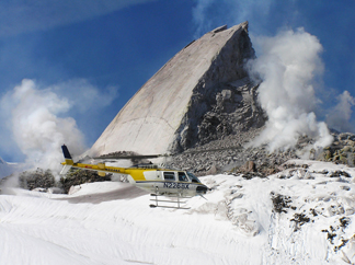 Mount
St. Helens has been growing a spine. Since mid-October 2005, a giant fin-shaped
slab of hot volcanic rock has emerged from the volcano’s crater,
rising more than 1 meter per day.
Mount
St. Helens has been growing a spine. Since mid-October 2005, a giant fin-shaped
slab of hot volcanic rock has emerged from the volcano’s crater,
rising more than 1 meter per day.