
|
 Subscribe

FEATURE
Riding the Wilson Cycle
Paul Silver
Plate tectonics was originally a theory about oceans. It described oceans opening and closing: how oceanic crust is created at mid-ocean ridges during seafloor spreading and how it is consumed at trenches by subduction. Apparently unique to the terrestrial planets (Earth, Mars, Venus and Mercury), plate tectonics is also a particularly efficient style of mantle convection, a relentless machine driven by Earth’s heat. But the theory itself, first proposed in the 1960s to supersede the older theory of continental drift and to include the newer concept of seafloor spreading, has since expanded in scope. As scientists develop increasingly better techniques to investigate crustal and mantle processes, they are also developing new, groundbreaking ways of thinking about this most fundamental geological theory.
 AGI/NASA |
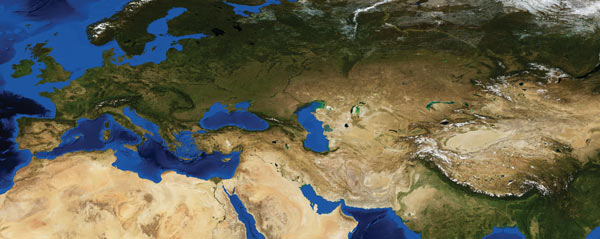
| The Alpine-Himalayan belt, which includes the European Alps, the Zagros Mountains in Iran, and the Himalayas, stretches from Spain to Indonesia and is the result of the closure of the Tethys Ocean over the last 250 million years. The closure of the Tethys and the resulting mountains is a classic example of part of the Wilson Cycle. |
One of the most significant advances appeared in a seminal 1966 Nature paper by J. Tuzo Wilson, in which he expanded the theory of plate tectonics to include the continents. While the original theory explained that the present-day Atlantic Ocean Basin formed when North America split apart from Eurasia, and South America from Africa, Wilson proposed that the formation of this basin was actually part of an ongoing cycle — in fact, that the Atlantic Ocean had previously closed and then reopened.
This alternating ocean opening and closing, continental breakup and continental collision — now termed the Wilson Cycle — is arguably the single most important principle in continental evolution, providing an elegant explanation for the semi-periodic creation of mountain chains throughout Earth’s history. But while the original oceanic component of plate tectonic theory is fairly mature, the Wilson Cycle and its implications are, by comparison, relatively unexplored. Some of the most exciting lingering questions include the evolution of continents and the operation of plate tectonics itself. New research is significantly adding to this picture.
Making mountains, making heat
When two continental plates collide, mountains will form. The Tibetan Plateau, the world’s highest plateau, represents the quintessential example of such a continental collision. It also represents the most dramatic success of the Wilson Cycle in describing the evolution of continents. The Wilson Cycle explains the high topography and thick crust of mountain chains such as the 10,000-kilometer- (6,200-mile-) long Alpine-Himalayan chain, the greatest continental topographic feature on the planet. Where these two continental plates collided, one would expect the crust to be much thicker — and indeed, for roughly a million square kilometers beneath the Tibetan Plateau, the crust is about twice as thick as average continental crust.
 Courtesy of Earth Sciences and Image Analysis Laboratory, NASA Johnson Space Center (ISS007-E-16057) |
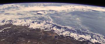
| The Tibetan Plateau (foreground) and Himalayas (middle), as seen from the International Space Station, are an example of a Wilson Cycle collision. |
So far, so good. But other aspects of Tibetan Plateau tectonics remain a mystery. The crust is part of a thicker lithosphere that includes the upper mantle, whose relatively cold temperatures give it increased plate-like strength compared to the hotter mantle below. Like the crust, the upper mantle portion of the lithosphere beneath the plateau should thicken as the continental plates collide, which should make the lithospheric mantle colder and stronger. Yet, the upper mantle in this region, in contrast, appears not only to be weak, but is also relatively hot, as evidenced by the low seismic velocities in the uppermost Tibetan mantle and the presence of active volcanism throughout much of the plateau. That is hardly what we would expect from thickened, cold lithosphere.
This unexpected heat, common to many mountain-building regions, has been termed the orogeny paradox. More than four decades after Wilson’s paper, this paradox still prevents us from declaring victory in understanding this particular collision. To resolve this discrepancy, researchers have hypothesized that the lithosphere deforms in ways that are more complex than the uniform shortening and thickening idealized by some deformation models.
Such complex lithospheric deformation might occur for a number of reasons: The crust and mantle could separate, or “delaminate,” due to the inherent instability of the cold, dense upper mantle overlying the warmer, more buoyant mantle below. Or, large-scale “channelized” flow of ultra-low viscosity material in the relatively hot, weak lower crust might be prying apart crust from mantle.
A robust method to evaluate how the lithosphere actually deforms involves comparing patterns of deformation observed at the surface with those in the mantle. Global Positioning System (GPS) measurements show the degree of surface displacement and enable us to map deformation at Earth’s surface, while seismic anisotropy — how seismic waves move at different speeds in different directions — reveals deeper mantle deformation.
Along those lines, there has recently been an explosion of both mantle seismic anisotropy and GPS data for central Asia as well as advances in their joint analysis. In a study performed by C-Y Wang, L. Flesch and myself (submitted to Geology in 2007), we found that Tibet and the surrounding regions clearly exhibit uniform (referred to as “vertically coherent”) crust and mantle lithospheric deformation, rather than the more complex styles of deformation suggested above. This result, while bringing us full-circle back to our simplest ideas about how the lithosphere deforms during a continent-continent collision, does not help us to resolve the orogeny paradox — particularly the question of why there is excess heat in the upper mantle after a Wilson Cycle collision. Indeed, we have now eliminated most of the proposed solutions. Consequently, we must search for another means of heating the uppermost mantle during the mountain-building process.
One possibility is that the deformation itself is the source of that heat. In a 1996 Earth and Planetary Science Letters paper, Chris Kincaid of the University of Rhode Island and I created a very simple model that suggested this would work, although more detailed and realistic modeling of the central Asian collision is still needed. But if this is the answer, the stresses of mountain building would have to be much higher than is normally assumed. At present, the stresses applied to Tibetan lithosphere appear to be low — but the collision has been in progress for about 50 million years, which has already dramatically weakened the lithosphere. Models simulating the plateau’s evolution over time suggest that the stresses in the past may have been 10 times greater, and therefore capable of generating significant heat.
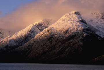 Photo by Michael Collier |
| The building of the Alps triggered the processes that raised the Andes. As seen here, the Patagonian Andes rise above Seno Union west of Puerto Natales, Chile. |
How the Alps helped make the Andes
The Wilson Cycle also has a longer-range effect on mountain building. On the other side of the world from the Himalayas lies another great mountain chain, the 14,000-kilometer- (8,700-mile-) long cordillera that forms the western backbone of the Americas and includes the Andes. These mountains were not caused — at least not directly — by a Wilson-esque continent-continent collision, however.
Cordilleras can form where an oceanic plate subducts beneath a continental plate, such as the Nazca Plate sliding beneath South America. But unlike the collision of two continental plates, whether a cordillera will form is not governed by how quickly the two plates converge. Instead, the determining factor is whether the overlying plate moves toward its own subduction zone, forming a cordillera, or away from it, forming a marginal basin in the overlying plate.
Although its impact is not obvious, the Wilson Cycle nevertheless plays a central role in this process, because both continental collision and continental breakup can change the velocity and direction of the overlying plate. After the Atlantic Ocean began to open, first in the north, and later in the south, the North and South American continents moved more quickly westward and the cordilleras soon began to grow. In addition, Africa’s collision with Eurasia 35 million years ago produced the Alps and abruptly stopped the motion of the African Plate, while simultaneously causing the South American Plate to move more quickly to the west, due to the coupling of both plates to mantle convection below, as Ray Russo, Carolina Lithgow-Bertelloni and I showed in a 1998 paper in Nature. That increase in westward motion, in turn, increased the intensity of mountain building in the Andes: Thus, it appears that the Alps helped make the Andes — and, more generally, that cordilleras are really just the other side of the Wilson Cycle.
The incredible shrinking continents
Many geologists take a “uniformitarian” view that, on balance, the deformation produced by the Wilson Cycle of continental breakup and collision neither grows nor shrinks the area of continents. This view is comforting, in a way: It holds that the Wilson Cycle just rearranges continental fragments while plate tectonics cools the planet, and leaves no other lasting effect.
A simple reflection on breakup and collision, however, suggests that this is not true. When continents break apart, the total area does not change much: There is a minor amount of stretching, after which the continent “breaks,” the seafloor spreads and oceanic crust forms. There is no further effect on actual continental area.
Collisions are fundamentally different, however. When two continents crumple together, the land is effectively shortened across thousands of kilometers. Shortening of land, such as that which occurred when the Alpine-Himalayan chain formed, can occur on scales and at rates that are an order of magnitude larger than the stretching from the breakup of continents, as well as the extension observed in continental rift zones (such as the North American Basin and Range Province and the East African Rift).
As Brian Hahn, a geology graduate student at Stony Brook University, and others show in a paper submitted to Earth and Planetary Science Letters, we can even quantify this extension-versus-shortening today using GPS, and then correct that for the likely effect over a full Wilson Cycle. The impact is dramatic. Over a full cycle — about 500 million years — the land area is expected to shrink about 25 percent. If this went on for a few Wilson Cycles, a supercontinent would end up looking like a skyscraper.
And yet this obviously does not happen, because continental area appears not to have changed much since the end of the Archean (about 2.5 billion years ago) and we see no such skyscrapers. Erosion and sedimentation are the likely balancing processes. Obtaining a real balance, however, requires that we relax the definition of “continent” to include taking oceanic lithosphere, adding continental sediments on top and calling that a continent.
Over time, these “imposter” continents, such as the accretionary belts of westernmost North America, have become a progressively larger fraction of the total amount of continent, compared to “true” continental crust made by igneous processes. There is, consequently, a basic asymmetry to the Wilson Cycle that is responsible for a gradual, yet fundamental, shift in the makeup of continental crust and upper mantle, which increasingly shifts the ratio of “true” continents to “imposters.”
Turning the wheel
Plate tectonics and the Wilson Cycle, in their idealized forms, reflect the world views of two great geologists: the uniformitarian, “present-is-the-key-to-the-past” vision of Charles Lyell; and the eternal cycling of uplift and erosion espoused by James Hutton. The plate tectonic conveyer belt that creates and consumes oceanic crust appears eternal, operating early in Earth’s history much as it does today — indeed, we are still actively searching for its beginning. Likewise, Wilson’s original conception suggested endless repetition: The Atlantic opened, closed and reopened in about the same place — and I am sure that he expected it to close again in the future.
Cycles are attractive as they provide a compact description of history. But in fact they actually deny history, as eloquently argued in Stephen Jay Gould’s book “Time’s Arrow, Time’s Cycle.” If it were true, there would be little difference between the first and second Atlantic Ocean openings, or between the formation of successive mountain ranges. These are merely different turns of the same wheel.
The real Wilson Cycle, however, is less than perfect, and its flaws actually make it more interesting. As we have seen, this cycle appears to be a source of heat and magmatic activity that is paradoxically present in so many collision zones. It reaches across ocean basins through its interaction with the convecting mantle to create cordilleras along the way. The Wilson Cycle’s asymmetry of breakup and collision is gradually transforming what we call continents into an odd kind of plate that is more oceanic than continental. And finally, there appears to be more than one way to close an ocean basin — such as closing the Pacific instead of the Atlantic, as Brendan Murphy of St. Francis Xavier University and Damian Nance of Ohio University discuss in a 2004 paper in American Scientist. Such issues are the subject of ongoing study, and could ultimately lead to new ideas that change the way we think about how plate tectonics has operated throughout Earth’s history. Riding the Wilson Cycle can be a wild ride, indeed.

