
|
 Subscribe

FEATURE
X-ray Eyes in the Sky
Carolyn Gramling
Satellite Roll Call Print Exclusive
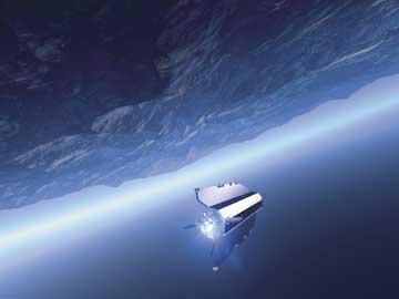 ESA |
| An artist’s conception of GOCE (Gravity Field and Steady-State Ocean Circulation Explorer) as it measures Earth’s gravity from orbit. |
Earth, viewed from space, may conjure up an iconic image of a friendly blue planet, perhaps obscured with clouds and storms, nostalgically and lovingly photographed by homesick astronauts. In recent years, increasingly detailed satellite pictures of this watery, windswept world have graced everything from weather maps to screensavers, but have been mostly limited to images of Earth’s exterior. Now, scientists are working on the next generation of low-orbiting satellites that they hope will see far past the planet’s surface and into its interior, to better understand the structure and composition of Earth’s crust, mantle and core.
Scientists have many ways of studying the planet’s surface and atmosphere from both ground and space, but looking into its interior is “much more difficult,” says Roger Haagmans, a geophysicist at the European Space Agency’s Earth Sciences Division. “Looking inside the Earth, it’s like you’re blindfolded, just feeling with your hands,” he says.
To look deep into Earth from space may seem counterintuitive, but scientists are excited by satellites’ potential to view the whole planet in a way that ground-based instruments cannot. Orbiting Earth singly or in fleets, satellites can cover a lot of ground, making them uniquely able to observe spatial and temporal changes at large scales.
Although peering directly inside the planet isn’t possible, Earth’s gravity and its magnetic field can offer a window into this inner world. Gravity anomalies, read by satellite, can tell of dynamic changes in Earth’s crust such as volcanism and earthquakes, and can also reveal deeper structural variability in the planet, while changes to its magnetic field may reveal patterns of circulation in the mantle and core. By combining these satellite data with the high-resolution data from smaller-scale land-bound instruments, scientists hope to develop a richer, more detailed understanding of Earth’s interior.
The Power of Attraction
Gravity attracts us, as bodies of matter, to Earth and, on a much smaller scale, it to us. Such gravitational attraction is proportional to mass. Earth’s mass is disproportionately distributed across the planet, however. In addition to its constantly shifting tectonic surface, the planet’s own rotation causes it to bulge at the equator and get flatter at the poles. As a result, this power of attraction is also disproportionate across the globe.
These slight variations in gravitational pull define an oddly shaped version of Earth called a “geoid,” a bumpy globe with bulges and pockets that represents how the surface of the planet would hypothetically look if it happened to be entirely covered with water. Because the geoid is related to gravity variations, it bears little resemblance to the familiar topographic surface of Earth — and, in fact, provides a different way of looking deeper into Earth’s inner structure.
Over the past decade, a handful of satellite missions — some still ongoing — have been launched to better measure Earth’s gravitational field, and now provide new, detailed images of Earth’s geoid, revealing features that would have been undetectable from the planet’s surface.
NASA’s Gravity Recovery and Climate Experiment (GRACE) was launched in 2002 and consisted of a pair of twin satellites that measured the gravity field of Earth and assessed its variability in both space and time, creating monthly maps of the gravitational field throughout the mission’s lifetime. The two satellites flew in tandem, keeping track of the precise distance between them (about 220 kilometers, or 137 miles) and thereby measuring the pull of gravity across the planet: Whenever one satellite would pass over a high- or low-gravity region, it would respond to the change in gravity’s pull slightly before the trailing satellite. Such differences in response slightly alter the distance between the two satellites, and scientists use those changes to measure the gravity field.
GRACE’s satellites recently helped solve the mystery of a region of unusually low gravity in Canada. In the 1960s, the first maps of Earth’s gravity fields showed a low-gravity anomaly across a large swath around Hudson Bay. Why the anomaly existed remained ambiguous, however, until geophysicist Mark Tamisiea of the Harvard-Smithsonian Center for Astrophysics in Cambridge, Mass., and his team used four years of GRACE data to study the problem.
Publishing May 11 in Science, Tamisiea and his colleagues revealed that the Laurentide Ice Sheet, which once pressed weightily down on a broad region extending from the Arctic through eastern Canada and the northern part of the Midwestern United States, had left a deep impression in Earth’s crust from which the land surface is still rebounding.
That depression and the ongoing uplift, the team found, contribute to less than half of the low gravity anomaly. They then inferred that the rest of the anomaly is likely due to mantle convection, where flow of molten material in the mantle shifts tectonic plates not only horizontally but also vertically. That motion, they wrote, drags continents downward like rafts atop sinking water currents. That sinking decreases the mass in that area, and therefore changes the gravity signal. Although theorized for four decades, the mantle’s gravitational signal would have been difficult to detect directly without the precision of the GRACE data.
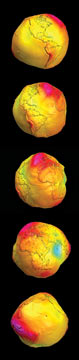 GFZ Potsdam |
| Data from Germany’s CHAMP (Challenging Minisatellite Payload) and NASA’s GRACE (Gravity Recovery and Climate Experiment) missions translate into a series of oddly bulging Earths, which represent variations in gravitational pull across the planet. |
Other recent satellite missions have also expanded scientists’ understanding of Earth’s magnetic field. Liquid iron in the outer core of the planet moves as Earth rotates, creating a self-sustaining dynamo effect that generates a magnetic field around the planet. The field is vitally important to Earth: It shelters the planet from the ionizing effects of the solar wind, periodic barrages of charged particles emanating from the sun that interact with Earth’s atmosphere (see Geotimes, June 2007). It is oriented around the planet as though a magnetic pole were driven through its center, with its north and south ends aligning roughly with Earth’s axis of rotation.
Many factors can interfere with measuring the strength of that internally generated field: In addition to changes in the core itself, magnetic storms caused by solar wind, electric currents in Earth’s ionosphere and even ocean waters, which contain charged particles and generate electric currents as they move, all can contribute to measurements. To study variability deep in Earth’s core, therefore, these signals first need to be teased apart.
Precise measurements from satellite constellations, when combined with other ground-, ship- or aircraft-based instruments, can help to distinguish these different sources. In 1999, Denmark launched its Ørsted satellite to create a highly precise map of the planet’s magnetic field and measure the contributions from different sources. For 14 months, the satellite collected data that were combined with measurements taken by ground-based instruments, assessing changes in the magnetic field that come not only from Earth’s own internal dynamo but also from the ionizing effects of the solar wind. Removing the solar wind’s contribution and creating a precise map of Earth’s own magnetic field through time and space are key goals for geophysicists interested in understanding not only dynamics in Earth’s mantle but also the long-term fluctuations of the field emanating from the core.
Ørsted, along with Germany’s CHAllenging Minisatellite Payload (CHAMP) mission (launched in 2000 and orbiting at low altitudes near the poles) has been helping scientists discover new information about Earth’s magnetic field. Comparing data from these two missions with earlier data from Magsat, a 1979 NASA satellite that mapped the magnetic field at the time, scientists found that Earth’s magnetic field strength has decreased over the last three decades. One reason for this is that the field may now be on the wane as the planet’s poles prepare to swap places.
This has occurred many times in the past, according to the seafloor rock record: Lava welling up at seafloor spreading ridges contains iron-rich minerals that freeze in the orientation of the surrounding magnetic field as the lava cools. Millions of years of such rock records suggest that Earth’s polarity has reversed many times throughout its history, most recently about 750,000 years ago. Such a change could be potentially devastating, because the field may weaken while the poles shift, leaving the planet exposed to dangerously high levels of solar radiation.
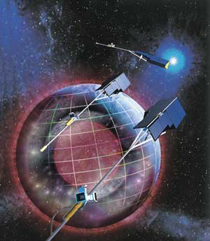 ESA |
| Swarm, a three-satellite mission led by the European Space Agency and scheduled to launch in 2010, will measure Earth’s magnetic field from different altitudes and orbits. Scientists hope the constellation of satellites will give new insight into the structures of both the mantle and core. |
Ørsted and CHAMP also discovered a hole in Earth’s magnetic armor: Called the South Atlantic Anomaly, it is a region over the South Atlantic Ocean where radiation intensity at the planet’s surface is particularly high due to a natural dip in the planet’s magnetic field. The satellites show that this region is growing wider, toward the southern Indian Ocean, possibly as a result of the overall changes in Earth’s magnetic field strength. This region is particularly significant for satellites and spacecraft that pass through the anomaly periodically, such as the Hubble Space Telescope, because they are exposed to several minutes of intense radiation that can result in glitches in data and operations, and can cause adverse health effects to astronauts.
New Views from Above
Seeking more precise maps of gravity anomalies across Earth, which can help explain the physics and dynamics that underlie volcanoes, earthquakes and rebound after glaciation, the European Space Agency (ESA) is now gearing up to send out another gravity-measuring satellite: The Gravity Field and Steady-State Ocean Circulation Explorer, or GOCE, scheduled to launch in late 2007. ESA is also preparing to launch its Swarm project in 2010 to collect more data on Earth’s magnetic field. This information, added to that from Ørsted and CHAMP, will become part of a database of more than a decade of high-precision observations of the magnetic field and how it is changing through time and space.
Swarm’s magnetic measurements will provide a new way of looking at Earth’s interior at multiple depths, says Haagmans, principle scientist of ESA’s Solid Earth Science and Applications Department. To better sort out the different contributions to the overall magnetic signal — from the crust, mantle and core — the project will consist of three satellites: two flying side by side 150 kilometers (93 miles) apart, at about 450 kilometers (280 miles) above Earth’s surface, and a third that will fly higher, more than 500 kilometers (310 miles) above the surface. Together, the three satellites will give simultaneous snapshots of the magnetic field over different regions of Earth, Haagmans says.
 ESA |
| The European Space Agency plans to launch GOCE in late 2007. |
Aside from the odd earthquake or volcanic burst, the crust’s magnetic signal will essentially be unchanging during the mission’s lifetime, he says. That means that, once measured, scientists can remove its measurements from the data and focus on variations occurring deeper in the planet’s interior. The mantle, meanwhile, contains conductive fluid that circulates over long periods of time and generates its own electric currents. Those currents cause magnetic changes that scientists can use to estimate the electrical conductivity in the mantle.
“If you look at gravity and seismic data, they give a kind of accumulated view of how density is distributed inside Earth,” Haagmans says. Now, with Swarm’s three satellites, scientists can get a kind of three-dimensional picture of the mantle’s conductivity and structure, adding another constraint to estimates of mantle temperatures provided by seismic and other data, he says.
Then there’s the core, the ultimate source of the magnetic field. Scientists still do not fully understand how the fluid outer and solid inner core move and behave with respect to each other, and the possibility that the field may be waning is of great interest, Haagmans says. By separating out all the other contributions to Earth’s magnetic field, he and his team hope that they will be able to learn much more about the current state of the dynamo.
Studying Earth’s inner secrets at a global scale, these orbiting eyes might change the way we look at our world. They may also provide a global view in more ways than one: Many of the recent, ongoing and upcoming missions are international collaborations between agencies, which plan to share data and processing tasks in the interest of taking the larger view. It may be that the combined vision of these many eyes, looking both outward and inward, will give startling new insights into the hidden heart of our blue planet.
Links:
"Sun cycle to flare back up in 2008," Geotimes, June 2007

