Laura Wright
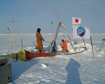
Scientists deploy one of the five Japan
Marine Science and Technology Center
buoys for their station. From left to right:
Dean Stewart, Sigrid Salo and Kiyoshi
Hatakeyama. James Morison, UW.
| Geotimes Home | Calendar | Classifieds | Advertise | Subscribe |
| Geotimes
Published by the American Geological Institute |
Newsmagazine of the Earth Sciences
June 2000 |
Monitoring the Arctic
| Shifts in ocean circulation
and thinning sea ice in the Arctic Ocean affect the overturn of the Atlantic
Ocean, and in turn global climate, making the North Pole region well suited
for long-term oceanographic monitoring to assess how the Arctic helps regulate
global climate. In early April, the National Science Foundation deployed
the North Pole Automated Station project, through which drifting buoys
will measure water and ice temperatures, salinity, ice thickness, solar
radiation and other variables. James Morison of the University of Washington
leads the international team of researchers that will run the five-year
project. Eventually, some of the buoys will drift with ocean currents into
the Greenland Sea, where they will catch Atlantic currents, while others
will be anchored to the ocean floor for permanent monitoring of the North
Pole region.
Laura Wright |
Scientists deploy one of the five Japan Marine Science and Technology Center buoys for their station. From left to right: Dean Stewart, Sigrid Salo and Kiyoshi Hatakeyama. James Morison, UW. |
Oil to methane
Robert Anderson and Derek Lovley of the University of Massachusetts, Amherst, have found evidence showing that saturated hydrocarbons decay into methane gas in deep sediments. Until now, most scientists believed that hydrocarbons were resistant to anaerobic decay, which would explain why deep oil reservoirs isolated from water and oxygen survive over geologic time. Anderson and Lovley incubated samples of sediment taken from an oil-contaminated aquifer in Bemidji, Minn., under anaerobic conditions to simulate the deep petroleum reservoir environment. They found that hexadecane, a saturated hydrocarbon, was converted to methane over time. The findings, published in the April 13 Nature, shed new light on the processes through which oil is converted into methane.
Laura Wright
New York's fault
The Appalachian Plateau in the northeastern United States may be criss-crossed by hundreds of faults. Robert Jacobi, John Fountain and students of the State University of New York at Buffalo combined recent data from Landsat with hyperspectral data, SLAR (Side-Looking Airborne Radar) data, topographic maps and air photos to identify lineaments, surface features hinting at faults. Working with Quest Energy, they suggest that lineaments matching gravity and magnetic anomalies correspond to faults in the Precambrian basement. Field work as well as seismic and well-log analyses support this theory, Jacobi says. He estimates that the Appalachian Plateau between Albany and Buffalo actually contains hundreds of faults running in several directions. Theres always been this idea that the Appalachian Plateau was essentially structurally featureless; these data demonstrate that such a view is incorrect. Jacobi and his students presented their findings during the March 13-15 annual meeting of the Northeastern Section of the Geological Society of America in New Brunswick, N.J.
Kristina Bartlett
 |
Geotimes Home | AGI Home | Information Services | Geoscience Education | Public Policy | Programs | Publications | Careers |